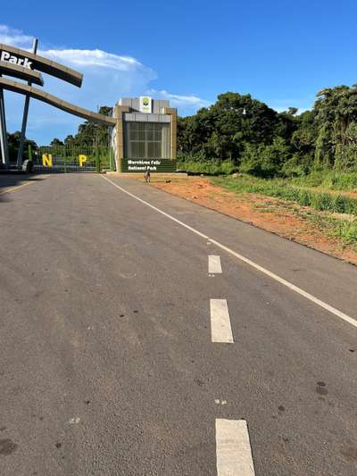
In October 2024, stopping briefly at the entrance to Murchison Falls National Park in northern Uganda, I photographed something that seemed almost out of place: a smooth, freshly laid asphalt road with crisp white lane markings and a new visitor centre at the park gate. The contrast with Uganda's older road infrastructure was sharp. Across the country, road quality varies dramatically — from expressway-standard paved highways to rutted murram tracks that require four-wheel drive in the wet season. Understanding that contrast is essential for understanding what the Kampala-Entebbe corridor represents and why it matters so much for Uganda's development.
The 42-kilometre road between Kampala and Entebbe is Uganda's most trafficked intercity route. Every international visitor arrives at Entebbe International Airport and must travel this road to reach the capital. Every package of Lake Victoria tourism — Ssese Islands, Mabamba Bay wetlands, Lutembe Bay birdwatching, Entebbe's own lakeside attractions — begins with this journey. The quality of that experience, from landing to lakeside, sets the tone for everything that follows.
Entebbe: Uganda's Gateway on Lake Victoria
Entebbe sits on a peninsula that extends into the northwestern edge of Lake Victoria. The town is defined by its relationship with the water: the international airport occupies the southern part of the peninsula with lake views from both sides, the Uganda Wildlife Education Centre (Entebbe Zoo) borders the lake shore, and botanical gardens laid out during the colonial period provide green space between the old town and the waterfront.
For most international visitors, Entebbe is simultaneously the first and last place they see in Uganda. The airport 42 kilometres from Kampala is the country's only international gateway, processing all inbound and outbound international traffic. The town itself is quieter and more manageable than Kampala, and many visitors choose to spend their first night here before heading inland — a sensible choice that also allows time to acclimatise and make arrangements for onward travel.
The proximity to Lake Victoria is not incidental. Entebbe is the departure point for ferries to the Ssese Islands, the base for boat tours to Mabamba Bay Wetlands to see the shoebill stork, and the location of Lutembe Bay — an Important Bird Area on the lake's shore. For anyone interested in Lake Victoria's ecology, wildlife, and island communities, Entebbe is the natural starting point.
The Corridor's Role in Uganda's Greater Kampala Planning
Uganda's Greater Kampala Urban Growth and Development Area (GKUGA) is a metropolitan planning framework covering Kampala city and surrounding districts including Wakiso, within which the Entebbe corridor sits. The integrated urban masterplan developed by a JICA-supported planning team identifies three primary development corridors radiating from Kampala: the northern corridor toward Gulu, the eastern corridor toward Jinja, and the southern corridor toward Entebbe.
The Entebbe corridor is one of three corridors designated in the GKUGA plan, with secondary urban centres planned at Zana, Kajjansi-Bwebajja, and Entebbe itself. The planning concept is transit-oriented development (TOD): urban growth concentrated around transport nodes in a way that reduces car dependence, improves access to services, and limits sprawl into sensitive environmental areas including the Lake Victoria shoreline and adjacent wetlands.
The transport networks envisaged in the corridor plan include roads, bus rapid transit (BRT), light rail transit (LRT), and metro rail transit (MRT). These are ambitious proposals for a country at Uganda's income level, and the timeline for implementation extends across multiple planning periods. But the strategic direction — integrating urban centres along the corridor with efficient public transport — reflects an attempt to manage growth before it becomes unmanageable, as it has in Kampala's congested city core.
Road Quality and the Real Experience of Travel
Traffic congestion between Kampala and Entebbe is one of the most discussed practical challenges in Uganda's transport system. According to Kampala Capital City Authority records, traffic congestion costs the metropolitan economy approximately UGX 500 million per day in wasted fuel and lost productive time. During peak hours, the 42-kilometre journey that takes 45 minutes at midnight can stretch to two hours or more in the morning rush.
The Entebbe Expressway, opened in sections from 2018 onwards, provides a tolled fast route between the airport and Kampala that partially alleviates this congestion for travellers who can afford the toll. The expressway has significantly reduced journey times for international visitors arriving by air and for freight moving between the airport and the capital. The older Entebbe Road remains the alternative for local traffic and those who avoid the toll.
For travellers venturing beyond the Kampala-Entebbe axis, road quality is more variable. During visits in October 2024 and January 2026, the differences between recently rehabilitated sections and older stretches were immediately apparent — smooth tarmac giving way to potholed surfaces, and back again as road improvement projects progressed. The current rehabilitation of the Masaka Highway, visible in January 2026, illustrates the rolling nature of Uganda's road upgrade programme: substantial sections are under active improvement at any given time, but progress is uneven across the network.
Tourism Infrastructure and the Lake Victoria Connection
Entebbe's position as the entry point to Uganda creates a concentration of tourist facilities — hotels, tour operators, vehicle hire, money exchange — that supports onward travel to every part of the country. From here, visitors board boats for the Ssese Islands, arrange guided tours to Mabamba Bay for shoebill sightings, drive north toward Queen Elizabeth National Park or Bwindi Impenetrable Forest, or travel east toward Jinja and the source of the Nile.
The Mabamba Bay Wetlands, a Ramsar-designated site roughly 15 kilometres west of Entebbe by air, are accessible by road and then by boat. The reserve is one of the most reliable places in Africa to observe the shoebill stork (Balaeniceps rex), and the tourism operation there — wooden canoes, local guides, a morning tour schedule — represents a functioning community-based ecotourism model that generates income at the village level.
Lutembe Bay, closer to Entebbe on the lake's eastern shore, is an Important Bird Area where flower farms along the shoreline create an unusual juxtaposition of commercial horticulture and bird habitat. The bay has been designated as a Ramsar Wetland site, recognising its international conservation significance. Both sites are practical day trips from Entebbe, accessible without the long overland journeys that characterise wildlife tourism elsewhere in Uganda.
Urban Development Pressures Along the Corridor
The stretch between Kampala and Entebbe has been subject to intense urbanisation pressure for decades. Settlements, commercial developments, and informal markets have expanded along the road corridor in a largely unplanned way, increasing traffic, reducing green space, and creating challenges for the wetland areas that historically buffered the Lake Victoria shoreline. The GKUGA planning framework represents an attempt to channel future growth more deliberately — toward designated urban centres and away from environmentally sensitive areas.
The Lake Victoria shoreline in this section of the corridor is under ongoing pressure from development. The National Environment Management Authority (NEMA) and the Kampala Capital City Authority (KCCA) have identified restoration of degraded riverbanks and lakeshores as a programme objective, with targets for area restoration included in the KCCA Strategic Plan through 2025. The tension between urban growth and lakshore protection is one of the defining environmental challenges of the corridor.
Mabamba Bay's Ramsar designation and Lutembe Bay's Important Bird Area status provide some degree of legal protection for these specific wetland sites. But the broader shoreline, outside formally designated protected areas, remains vulnerable to encroachment. Planning decisions made along the corridor in the next decade will determine whether the lake ecology that makes Entebbe and its surroundings attractive to visitors is preserved or progressively eroded.