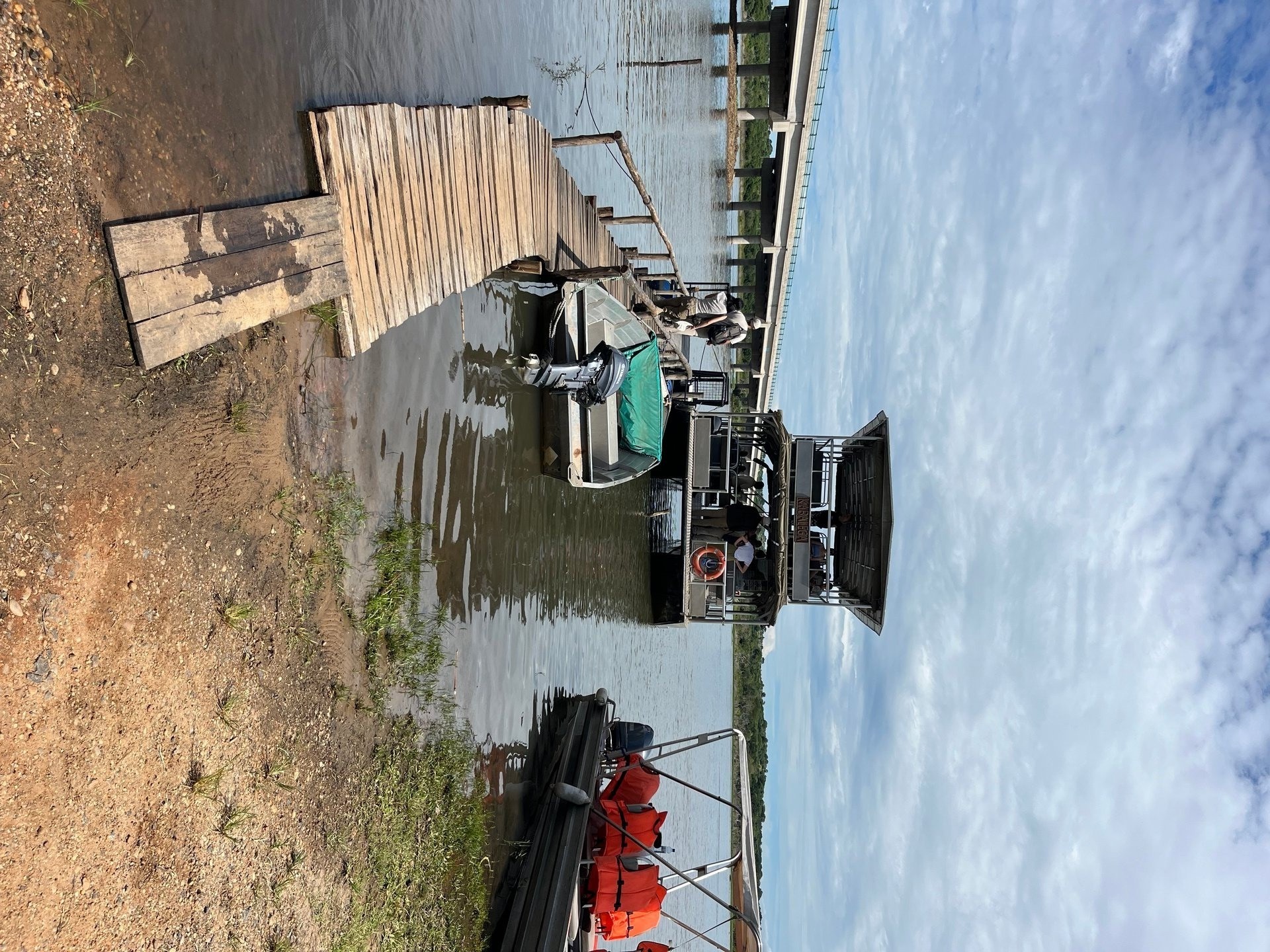
The boat was built for about fourteen passengers. It had life jackets and a shade roof, which on an October morning on the Victoria Nile mattered considerably. The boarding felt informal — a short jetty, the river quiet — and the boat itself moved with a certain instability that I noticed immediately. But within the first few minutes everything else fell away: a hippopotamus surfaced and submerged thirty metres away, a Goliath heron stood motionless on the opposite bank, and the river opened up ahead of us in a way that made the slight rocking feel entirely beside the point. That was Murchison Falls in October 2024, during a twelve-day trip through Uganda. By the following afternoon we were back south, crossing a different body of water entirely — the open lake, making for an island.
Lake Victoria has more islands than most people realise. The figure typically cited is over 3,000, distributed across Uganda, Tanzania and Kenya. The vast majority are small, uninhabited, and ecologically significant primarily as nesting or resting sites for waterbirds. A smaller number carry permanent human communities — fishing families who have lived on the water for generations, operating within a world that is connected to the mainland by boat and not much else. And a handful have been shaped specifically by conservation efforts or tourism development into destinations with visitor infrastructure. Understanding which is which — and how to reach them — is most of what you need to know before putting yourself on a lake crossing.
How Many Islands Does Lake Victoria Have — and Where Are They?
Lake Victoria's islands are not evenly distributed. The largest concentration on the Ugandan side is the Ssese Archipelago in the northwestern section of the lake — 84 islands ranging from substantial land masses with forest cover and multiple settlements to bare rocky outcrops with no permanent inhabitants. On the Tanzanian side, the Ukerewe Island is the largest single island in the lake, while Kenya's Rusinga and Mfangano islands sit in the northeastern Winam Gulf. The governance of these islands involves national authorities in all three countries, coordinated in part through the Lake Victoria Basin Commission (LVBC), the East African Community's body responsible for integrated management of the lake basin across Uganda, Kenya, Tanzania, Rwanda and Burundi.
The LVBC works alongside the Lake Victoria Fisheries Organisation (LVFO), which handles fisheries governance specifically — stock assessments, gear regulations, and the management of commercial fishing across the shared water body. For island communities whose livelihoods depend primarily on fish, these two organisations represent the institutional framework within which resource use is negotiated at a regional scale.
Lake Kyoga, Uganda's second major lake, sits northeast of Lake Victoria and is connected to it through the Victoria Nile. It has its own island communities and wetland systems, with significant documented biodiversity and socioeconomic importance for surrounding communities — though it sees far fewer visitors than the Victoria islands and has received considerably less conservation investment.
The Ssese Archipelago: Bugala, Bukasa and Banda Islands
Bugala Island is the largest island in the Ssese Archipelago and the practical gateway to the group. It is 34 kilometres long and carries a genuine town — Kalangala — with a market, basic services and accommodation options ranging from simple guesthouses to the Victoria Forest Resort, a lodge set on the lakeshore with a swimming pool, beach area, bicycle hire and various activity options. The forests in the interior of Bugala include areas of old growth, and the bird diversity is notable — including species rare or absent on the mainland. Getting to Bugala from Entebbe means crossing to Kasenyi, the fishing village 8 kilometres east of Entebbe on a peninsula below the Kampala road, and taking either the Uganda National Roads Authority vehicle ferry (approximately 4–5 hours crossing) or a faster water taxi service from Entebbe Port.
Bukasa Island is the more remote option within the Ssese group — heavily forested, sparsely populated, with five fishing settlements along its shoreline. It has beaches and a waterfall that receives very few international visitors, and its forest cover is intact in ways that Bugala's, with more development pressure, is no longer. Getting to Bukasa requires either a separate boat from Bugala or a direct crossing from Kasenyi, which takes longer. It is not a comfortable day trip from Entebbe, which is precisely what makes it interesting for visitors who want to spend time away from any hint of the tourism circuit.
Banda Island is small — approximately 80 hectares — and sits about an hour's boat ride beyond Bugala. It is home to Banda Island Resort, which has six accommodation types for up to 24 guests: a multi-bed room, cottages, beach cabins and a safari tent. The scale is deliberately limited, which keeps the island feel intact. Activities are water-focused: swimming, snorkelling, fishing, bird watching. There is no vehicle traffic on Banda, no grid electricity, and the sense of distance from the mainland is genuine rather than engineered.
[QUOTE: local Ssese islander on what has changed in the last decade]
What the Unnamed Islands Look Like from the Water
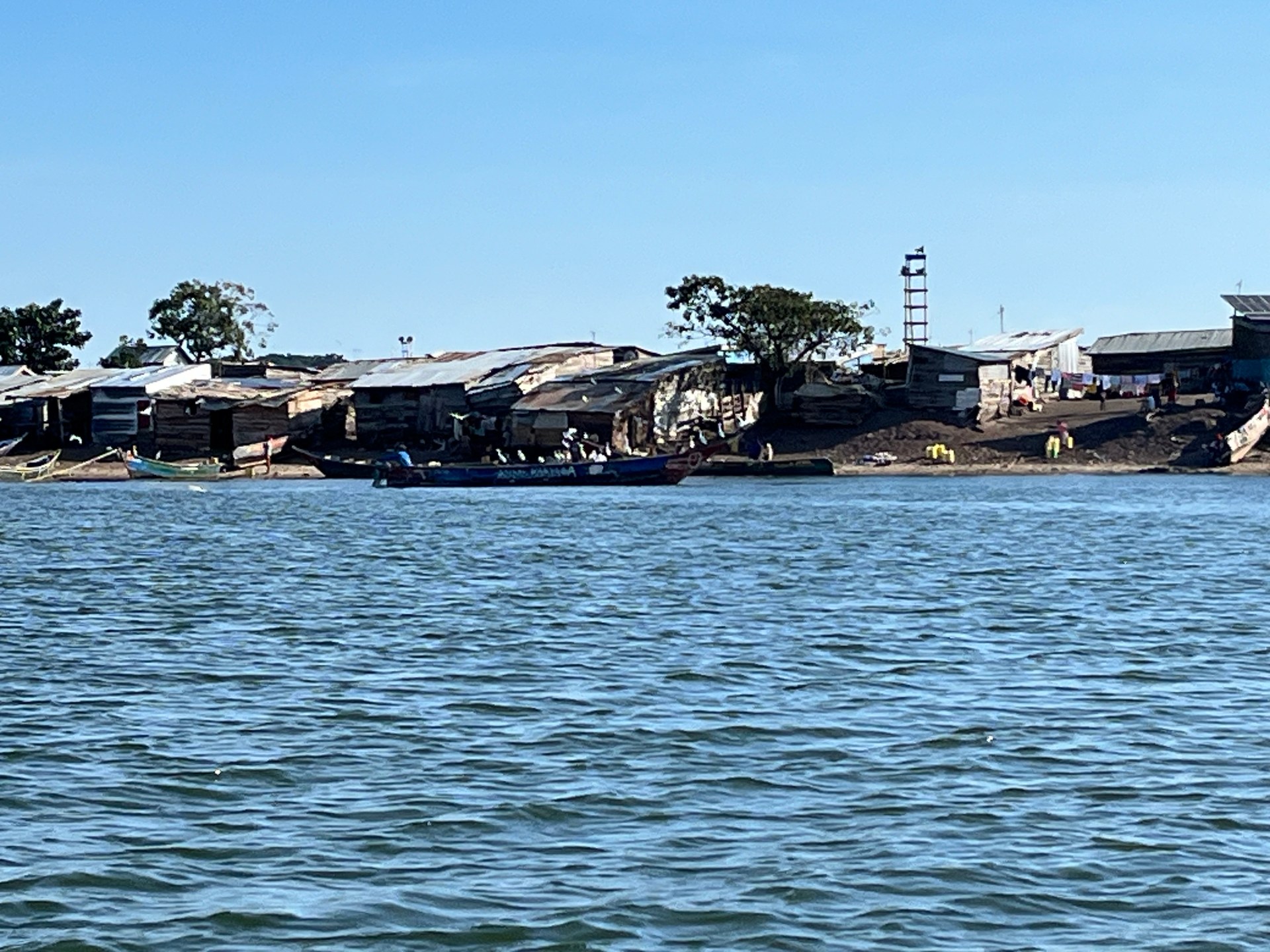
The small island we passed on the way to Ngamba was not in any itinerary. It appeared off the port side of the boat about halfway across the open lake — a low strip of land with corrugated iron rooftops visible above the treeline, wooden fishing boats moored at a rough landing, and the kind of activity that suggests a community going about its morning without any particular interest in passing vessels. There were perhaps two or three dozen structures visible. No power lines. No pier with tourist signage. The island sits at approximately 0.0847°S, 32.6508°E — a GPS coordinate that confirms what it looked like: a real working community, not a landmark.
From the boat, the life on that island was genuinely vivid. People moved between the houses and the shore, boats were being pushed out or pulled in, and the whole small ecosystem of a fishing settlement was operating at its normal pace. There is something about seeing a place from the water that removes the usual mediating layer of arrival and orientation. You observe rather than participate, and what you observe is simply how people live when no one is watching. That moment, for me, was one of the more memorable five minutes of the October 2024 trip — not because anything happened, but because it was entirely itself.
These unnamed fishing islands are distributed across the lake in large numbers. Most do not appear on tourist maps and are not designed for visits. They are fishing communities, with the rhythms and economics of fishing communities: early mornings on the water, afternoons processing and selling the catch, evenings doing everything else. The connection between these islands and Lake Victoria's commercial fishery is direct — they are landing sites, they provide access to fishing grounds, and they absorb the ecological and economic fluctuations of the fish stocks beneath the lake's surface. When Nile perch catches decline, the impact registers first on islands like this one, not in the commodity markets downstream.
Ngamba Island: A Chimpanzee Sanctuary in the Middle of the Lake
Ngamba Island is 98 acres of forested land in Lake Victoria, approximately 23 kilometres southeast of Entebbe. It is managed by the Chimpanzee Sanctuary and Wildlife Conservation Trust (CSWCT) and functions as a permanent refuge for orphaned and confiscated chimpanzees — animals that cannot be returned to the wild because they were removed from their social groups too early, or because the habitats those groups occupied no longer exist. Around 50 chimpanzees live on the island.
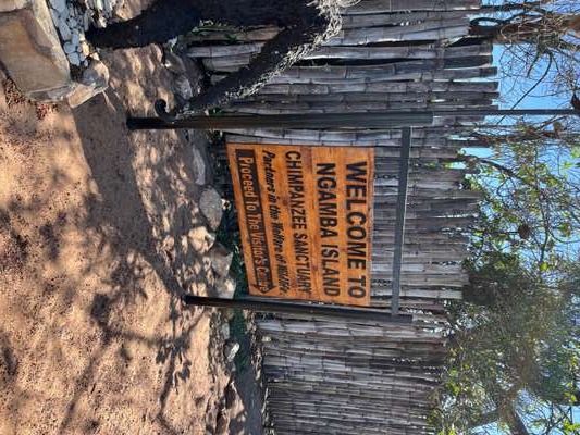
Day trips run from Entebbe, and the crossing takes approximately 45 minutes by the sanctuary's own boat. I visited in October 2024, and the arrival itself was a small pleasure: a hand-painted wooden welcome sign on an orange background, clearly made with care rather than commercial intent, greeting visitors at the landing. The lettering read "Ngamba Island Chimpanzee Sanctuary" and the whole sign had the character of something made by people who meant it. The welcome at the landing matched — direct, warm, and without any of the managed-experience quality that can make wildlife tourism feel transactional.
The chimpanzees are observed during supervised feeding sessions. They are not habituated in the gorilla-trekking sense — this is not a situation where you follow animals through forest for an hour. The feeding platform creates a predictable encounter, which means visibility is reliable even for visitors with limited time. The more substantive experience is the walk through the island's forest sections, which gives a sense of the habitat these animals occupy between feeding times. Ngamba is not a large island, but it is forested enough that the chimpanzees have genuine space and genuine shade.
Lake Governance: Who Manages the Shared Water
Lake Victoria sits across three national jurisdictions — Uganda, Kenya and Tanzania — with Rwanda and Burundi holding interests in the broader basin through the river systems that feed the lake. Managing a shared resource of this scale requires institutional coordination, and the primary vehicle for that coordination is the Lake Victoria Basin Commission (LVBC), operating under the East African Community framework.
The LVBC handles the broader sustainable development agenda: water resource management, environmental protection, infrastructure development and economic integration across the shared basin. It is a political and technical body, not an enforcement agency, which means its effectiveness depends substantially on national governments following through on the commitments made at the regional level. On fisheries specifically, the Lake Victoria Fisheries Organisation (LVFO) operates as a separate body with a more focused mandate — monitoring fish stocks, coordinating gear regulations, and managing the scientific basis for fisheries decisions. NAFIRRI (National Fisheries Resources Research Institute), based in Jinja at the lake's Ugandan outlet, provides much of the stock assessment data that LVFO uses.
For island communities, this governance architecture is not abstract. Fishing permits, gear restrictions, closed seasons and landing site regulations all flow from decisions made at the LVFO and implemented through national fisheries authorities. When those decisions reduce catch volumes in the short term — as sustainable management sometimes requires — the communities on the unnamed islands visible from passing boats are the ones who experience the difference most directly.
The lake's water quality is also a shared concern. Water hyacinth concentrations have been documented particularly in Murchison Bay on the northern shore near Kampala, with hotspots at Ggaba, Salama and Buziga in the Makindye Division (Multi-Hazard Risk and Vulnerability Profile 2018). Islands near these areas are affected when hyacinth mats block boat passages or smother fish habitat. The LVBC's water management mandate includes monitoring and coordinating responses to these kinds of invasive plant outbreaks, which recur wherever the lake's nutrient levels remain elevated.
Practical Information: Getting to Lake Victoria's Islands
For most visitors arriving at Entebbe Airport, the first island decision is whether to visit Ngamba Island (easy half-day from Entebbe, fixed itinerary, chimpanzee focus) or to cross to the Ssese Archipelago (longer journey, more flexibility, different character entirely). These are not competing choices — they serve different purposes — but they require different amounts of time and different travel arrangements.
Ngamba Island trips are bookable through the CSWCT directly or through Entebbe-based operators. The sanctuary boat is the standard transport. Kasenyi, 8 kilometres east of Entebbe, is the ferry departure point for the Ssese Islands — it functions as both a working fishing village and the embarkation point for the main vehicle and passenger ferry to Bugala Island. The Kasenyi crossing to Kalangala (Bugala) takes 4–5 hours on the ferry or 2–3 hours on faster water taxi services. The crossing is open lake, which means it is subject to weather. October — when I made my trip — is a transitional month between Uganda's short dry season and the short rains, generally stable on the lake but worth checking weather conditions before departure.
For Banda Island and Bukasa Island, the practical approach is to travel to Bugala first and arrange onward boat transport from Kalangala. There is no scheduled service to either island. The distances involved mean an overnight stay on Bugala is usually the sensible approach before continuing to the smaller islands.
Explore Further
Frequently Asked Questions
How many islands does Lake Victoria have?
Lake Victoria has over 3,000 islands distributed across Uganda, Tanzania and Kenya. The largest concentration on the Ugandan side is the Ssese Archipelago — 84 islands in the northwestern part of the lake. Bugala Island is the largest at 34 kilometres long, with the main settlement at Kalangala. Most of the lake's islands are small, uninhabited, and ecologically significant primarily as wildlife habitats.
How do you get to the Ssese Islands from Entebbe?
The main crossing departs from Kasenyi, a fishing village 8 kilometres east of Entebbe. The Uganda National Roads Authority vehicle and passenger ferry crosses to Bugala Island (Kalangala) in approximately 4–5 hours. Faster water taxi services from Entebbe Port take around 2–3 hours. October crossings are generally stable but weather conditions should always be checked before departure on open lake routes.
What is Ngamba Island Chimpanzee Sanctuary?
Ngamba Island is a 98-acre island 23 kilometres southeast of Entebbe, managed by the Chimpanzee Sanctuary and Wildlife Conservation Trust (CSWCT). Around 50 orphaned and confiscated chimpanzees live there permanently. Day trips from Entebbe take approximately 45 minutes by boat. Visitors observe chimpanzees during feeding sessions and can walk the island's forested sections. I visited in October 2024 — the welcome at the landing was genuine and warm, and the hand-painted sign at the dock set the tone accurately.
What is Banda Island on Lake Victoria?
Banda Island is a small island of approximately 80 hectares about 1 hour by boat from Bugala Island in the Ssese Archipelago. Banda Island Resort accommodates up to 24 guests in six room types including cottages, beach cabins and a safari tent. There are no vehicles on the island. Activities focus on swimming, snorkelling, fishing and bird watching. It is one of the more genuinely off-grid island experiences available on the Ugandan side of Lake Victoria.
What is the Lake Victoria Basin Commission?
The Lake Victoria Basin Commission (LVBC) is a regional intergovernmental body under the East African Community, responsible for coordinating sustainable development and integrated water resource management across the Lake Victoria Basin. It covers Uganda, Kenya, Tanzania, Rwanda and Burundi. The LVBC works alongside the Lake Victoria Fisheries Organisation (LVFO), which specifically handles fisheries governance including stock assessments and gear regulations across the shared lake.