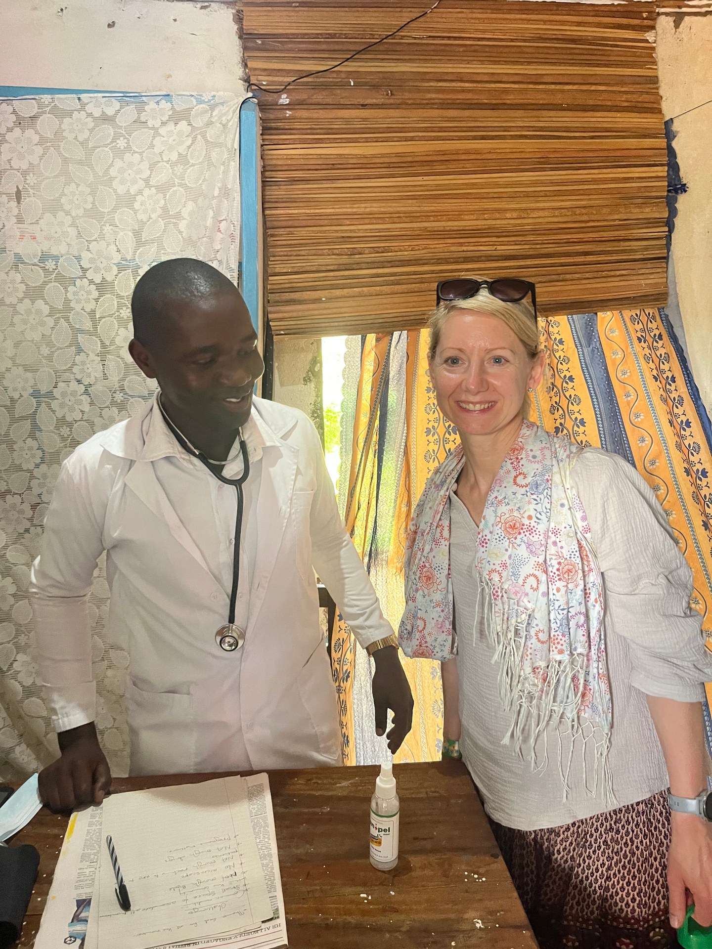
Susanne stands beside a local doctor in a small examination room somewhere in rural western Uganda. The walls are bare, the ceiling is raw timber, and a curtain of bright fabric separates the waiting area from the single bed in the back. The doctor is not always here — he covers several villages on an irregular schedule. The community wants to expand the facility but needs donations to do so. It is hard to look at this without feeling the weight of the gap between what exists and what is needed.
That photograph, taken on 10 October 2024 at GPS coordinates 0.8231° N, 34.3395° E, has nothing to do with Lake Victoria at first glance. But it captures something essential: the communities living around the lake are the people most directly affected by every environmental decision made about it. When fish stocks fall, their income falls. When water hyacinth blocks access to fishing grounds, it is not an abstract ecological problem — it is a missed meal, a missed school fee, a missed doctor visit. Understanding what is happening to Lake Victoria means understanding what is happening to the people who depend on it.
During my 12-day stay in Uganda in October 2024, I travelled across the country from Lake Victoria's northern shore near Entebbe to Mount Elgon and back — a route that brought me through fishing communities, small lakeside towns and the kinds of health centres and village schools that reveal the social texture of the landscape. What I saw on the lake itself, and what Uganda's National Status of the Environment Report 2024 (NSOER 2024) documents in detail, paints a picture of a body of water under serious and compounding pressure. It also shows a country that knows it has a problem and is beginning to address it systematically.
How Low Can It Go? Lake Victoria's Falling Water Levels
The single most alarming number in Uganda's NSOER 2024 regarding Lake Victoria is this: the lake's water level dropped to 12.99 metres in October 2024. For context, the lake's historical average sits comfortably above 13 metres, and the level has fluctuated significantly since the 1960s when the Nalubaale Dam (Owen Falls Dam) was completed near Jinja. The dam, Uganda's main hydropower facility, regulates outflow from the lake into the upper Nile — which means every megawatt generated represents water permanently leaving the lake basin.
The drop to 12.99 metres is not just a data point. It affects port depths, ferry routes, and the nearshore areas where the majority of Uganda's artisanal fishermen operate. Shallower water concentrates fish in deeper zones, initially appearing to increase catch rates before leading to overfishing pressure in those zones. It also exposes more shoreline to erosion, disturbs wetland habitats that serve as nursery grounds for juvenile fish, and reduces the buffer capacity that wetlands provide against flooding events during rain seasons.
The picture across Uganda's lakes is uneven. While Victoria fell, Lake Albert reached a record high of 14.90 metres in the same period — above its historical record of 14.68 metres (NSOER 2024, Part 5). These diverging trajectories reflect how different the catchment dynamics and human pressures are across Uganda's lake system. Albert is fed largely by the Rwenzori Mountains' snowmelt and the flow from Lake Edward; Victoria collects rainfall across a vast savanna and highland catchment. Both are changing in ways that NSOER 2024 links directly to climate variability and intensifying land use pressure upstream.
The Water Hyacinth Problem: A Plant That Changed the Lake
If you arrived at Lake Victoria's Ugandan shores by boat in the late 1980s or 1990s, you would have encountered something that looked, from a distance, like a meadow growing on the water. Dense mats of dark green floating vegetation, sometimes covering entire bays and harbour approaches, sometimes forming islands large enough to temporarily maroon fishing boats. Water hyacinth — Eichhornia crassipes — had arrived, and it would prove one of the most disruptive ecological events in the lake's modern history.
The plant is native to South America. Exactly how it reached East Africa remains debated, but by the time Ugandan fisheries researchers understood the scale of the infestation, it had established itself across the lake's Ugandan, Kenyan and Tanzanian shorelines. Its growth rate under Lake Victoria's warm, nutrient-rich conditions is extraordinary: a single plant can double in less than two weeks. The nutrient richness it exploits is itself partly a human problem — agricultural runoff, untreated sewage and industrial effluent from lakeside towns have elevated nitrogen and phosphorus levels across much of the lake, providing the fertiliser water hyacinth needs to thrive.
The ecological damage works through several mechanisms. Floating mats block sunlight, creating hypoxic (low-oxygen) dead zones beneath them where fish cannot survive. They trap debris and create stagnant water that becomes habitat for mosquito larvae. They physically obstruct access to fishing grounds — a fisherman who works the same bay his father worked may arrive one morning to find it entirely sealed under a mat too dense to paddle through. They entangle propellers and nets. And as the mats decay and sink, they extract yet more oxygen from the water column below.
Uganda's response has been primarily biological. From the late 1990s onwards, two species of the Neochetina weevil were introduced as biological control agents. The weevils feed exclusively on water hyacinth and do not threaten other aquatic vegetation. The results have been mixed but real: in combination with manual removal programmes and periodic wind events that break up and strand mats, the worst of the 1990s infestation has receded. However, NSOER 2024 documents continued presence of water hyacinth as an active pressure on aquatic biodiversity in Uganda's lakes, particularly when rainfall increases nutrient runoff from farms.
The connection to land use is direct and important. Uganda's NSOER 2024 identifies unsustainable farming practices, poor waste management and inadequate urban sanitation as the primary drivers of lake nutrient loading. Three national initiatives targeting climate-smart agriculture, improved waste management and sustainable tourism have been launched to address these pressures, though implementation across the lake's vast catchment area remains uneven (NSOER 2024, Part 2). The legal framework is increasingly strong: Uganda's National Environment (Waste Management) Regulations, S.I. No. 49 of 2020, require hazardous waste facilities to be sited at least 200 metres from protected areas, bird sanctuaries and wildlife management areas, and mandate that landfill bases sit a minimum of 1.5 metres above the groundwater table — direct measures to prevent chemical contamination from reaching lake tributaries.
Fish Stocks and the Nile Perch Question
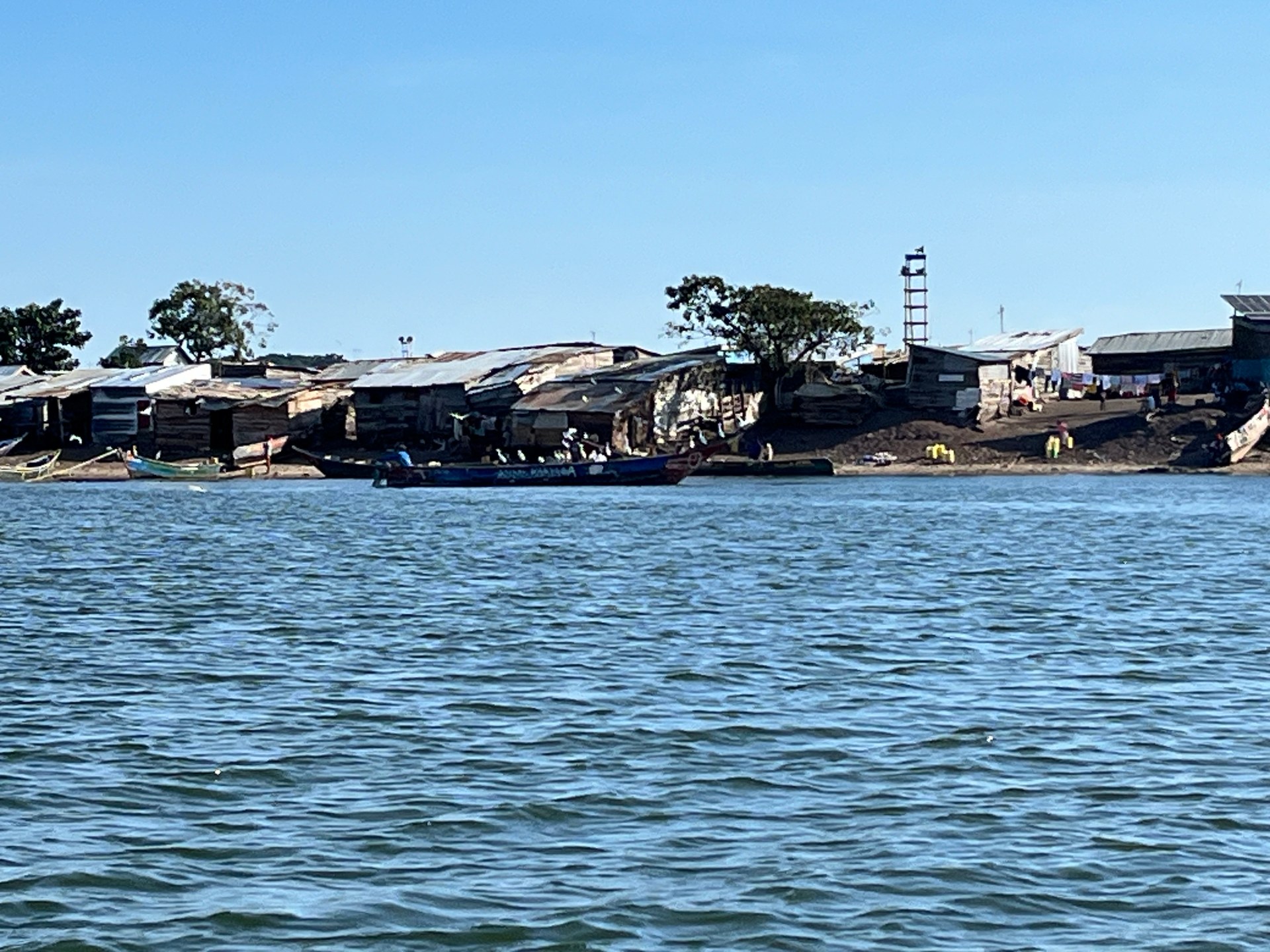
On 19 October 2024, travelling by boat from Entebbe to Ngamba Island, we passed close to a small fishing island mid-lake. From the water, the settlement was vivid with activity — wooden boats pulled up on a narrow beach, rooftops of corrugated iron catching the morning light, figures moving between structures that appeared to have no electricity or running water. The island was not large enough to have a school or a health centre. The people living there were entirely dependent on the lake for their livelihood and, in practical terms, for everything else.
What those fishermen catch has changed dramatically over the past 70 years. Nile perch (Lates niloticus) was introduced into Lake Victoria in the 1950s, initially into the Ugandan section. The introduction was not ecologically neutral — it was catastrophic for the lake's endemic cichlid fish. Over the following decades, Nile perch predation, combined with eutrophication, hypoxic zones and overfishing, drove several hundred endemic cichlid species to extinction or near-extinction. NAFIRRI, the National Fisheries Resources Research Institute based in Jinja, has documented this collapse extensively. What had been one of the world's most biodiverse freshwater fish communities — over 500 endemic cichlid species evolved over tens of thousands of years — was reduced to a fraction of its former richness.
The Nile perch itself became the economic engine of Lake Victoria's industrial fisheries. Uganda, Kenya and Tanzania together export significant volumes of processed Nile perch fillet to European and Asian markets. The fishing industry employs hundreds of thousands of people around the lake's shores. Mukene — the small sardine-like dagaa fish — forms the other pillar of the lake's commercial fishery, dried and processed for local consumption and regional markets.
But NSOER 2024 documents what fishermen on those islands already know: fish stocks in Lake Victoria are in decline. Overfishing, declining water quality, habitat degradation in nearshore wetlands, and competition for food resources between species have all contributed. The report identifies aquatic ecosystem degradation as one of the primary drivers of Uganda's biodiversity loss, with direct economic consequences — fewer fish means lower export revenues, lower income for fishing communities, and, as NSOER 2024 notes explicitly, reduced tourism income as the natural heritage that draws visitors diminishes (NSOER 2024, Part 1).
Key Biodiversity Areas: Protecting What Remains
Uganda's conservation response to these pressures includes a formal designation system for the country's most ecologically important sites. According to NSOER 2024, 196 Key Biodiversity Areas (KBAs) have been identified across Uganda — and a significant proportion of them are located not within Lake Victoria itself, but in the adjacent wetlands, river systems and forest patches that form the lake's ecological buffer zone.
The logic is important: Lake Victoria's open water, while vast, is not where the highest concentrations of irreplaceable biodiversity are found. The lake's endemic cichlid diversity was already severely depleted before formal conservation frameworks existed. The greatest remaining concentrations of threatened freshwater fish, macroinvertebrates and specialised aquatic plants are found in smaller, less disturbed water bodies — satellite lakes, river backwaters, papyrus swamps and forest streams — that fall within the lake's broader catchment area.
KBA designation does not automatically confer legal protection in Uganda. It is primarily a scientific classification that flags sites for priority conservation action. But it feeds directly into the Uganda Wetlands Management Program, which oversees the mapping, monitoring and partial restoration of critical wetland systems across the country. Wetlands around Lake Victoria perform multiple functions simultaneously: they filter agricultural runoff before it reaches the lake, provide nursery habitat for juvenile fish, buffer shoreline communities against flooding, and store significant quantities of carbon. Their degradation — through drainage for agriculture, urban expansion and brick-making — removes all of those services at once.
[ZITAT: Guide über den Zustand der Feuchtgebiete am Seeufer]
The Uganda Wildlife Authority (UWA) operates a complementary system of formally protected areas. Wildlife management regulations updated in 2022 (Uganda Wildlife Regulations 2022) expand the framework for protecting species and habitats outside Uganda's national parks. For the lake, this matters most in the management of the Sese Islands and other gazetted forest reserves that provide habitat continuity between the lake and Uganda's central forest zone.
Ngamba Island: Conservation on a Smaller Scale
Arriving at Ngamba Island on 19 October 2024, the first thing that struck me was how different it looked from the fishing communities we had passed on the way. The wooden welcome sign at the landing — hand-painted in warm orange tones, reading "Ngamba Island Chimpanzee Sanctuary" — set an immediately different tone. The island exists for a single purpose: to provide a permanent home for chimpanzees rescued from poaching, illegal pet trade and habitat loss.
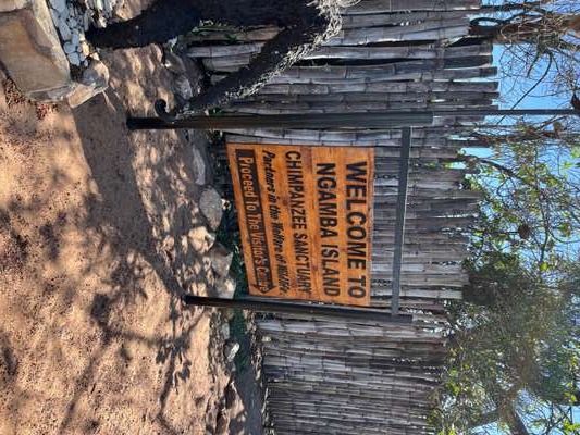
The enclosure fence that separates the visitor area from the chimpanzees' forest territory is a heavy metal structure — functional rather than decorative. My first reaction was that it looked harsh. But the context matters: behind that fence lies 98 acres of forested island that the chimpanzees have to themselves. They are not in cages. They are on an island in the middle of Lake Victoria, in a forest, living as close to a natural existence as animals that have been through trauma can manage. The fence marks the boundary of their territory, not their confinement.
Ngamba Island is managed by the Chimpanzee Sanctuary and Wildlife Conservation Trust (CSWCT). It is not a park attraction in the conventional sense — it is a working rescue and rehabilitation operation. The approximately 50 chimpanzees resident there in 2024 came from across Uganda and neighbouring countries. None of them can be returned to the wild; they lack the learned social skills and territorial knowledge that wild chimpanzees acquire from birth. The island is their permanent home.
The island's existence on Lake Victoria is both practically and symbolically significant. It demonstrates that conservation at scale — protecting Bwindi Impenetrable National Park, managing the Ssese Islands — must exist alongside smaller-scale, species-level interventions for animals that fall through the gaps of habitat protection. And it places that conservation work in the middle of the same lake ecosystem that faces water hyacinth, falling water levels and declining fish stocks: a reminder that the health of the whole and the fate of the individual are connected.
What Is Being Done — and What Still Needs to Happen
Uganda's environmental governance framework has strengthened considerably in recent years. The NSOER 2024 itself is a product of that strengthening — a comprehensive, multi-sector assessment covering the period 2022 to 2024 that documents challenges and state commitments with a level of rigour not previously available in a single public document.
On the legislative side, the National Environment Act, the Wildlife Regulations 2022, and the Waste Management Regulations (S.I. No. 49 of 2020) together create a reasonably robust framework. The 200-metre buffer requirement for hazardous waste facilities near protected areas, and the groundwater separation requirement for landfills, are not theoretical — they respond directly to documented contamination pathways that have affected lake tributaries in the past.
On the infrastructure side, the planned construction of 20 new landing sites and piers around Uganda's portion of Lake Victoria signals investment in the transport and tourism sectors. Better landing infrastructure reduces the use of informal, unregulated beach access points that currently contribute to nearshore erosion and waste disposal problems.
NAFIRRI continues its monitoring and research function. The institute's stock assessments, hyacinth monitoring and cichlid conservation programmes provide the scientific baseline without which none of the policy responses would be possible. Uganda also invested significantly in tourism and protected areas as a conservation strategy through the period covered by NSOER 2024 — recognising that healthy ecosystems are the foundation of the tourism sector that generates significant foreign exchange (NSOER 2024, Part 1).
What still needs to happen is harder to summarise. Agricultural runoff remains the dominant source of nutrient loading into the lake, and changing farming practices across a catchment that spans multiple countries and millions of smallholder farms is not a problem any single agency can solve. Water hyacinth will return in force whenever nutrient levels rise and weevil populations drop. Fish stocks require sustained effort to rebuild, and the political economy of fisheries — where short-term catches matter more than long-term yields for communities without savings — makes restraint difficult to enforce.
What is clear from the NSOER 2024, and from everything visible from a boat on a grey October morning mid-lake, is that Lake Victoria does not have the luxury of slow responses. The lake provides water, food, transport and livelihoods to over 40 million people across three countries. What happens to it matters far beyond its shoreline.