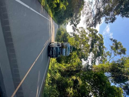
Somewhere between Butiru and the Murchison Falls National Park entrance, our vehicle slowed behind an extraordinary sight. A minibus was making its way down the well-surfaced road with its entire cargo volume doubled — not inside the vehicle, but stacked on the roof. Mattresses, bundled household goods, and what appeared to be rolled-up foam piled nearly as high as the bus itself. It was a peculiar image by European standards, the kind of load that would attract immediate attention from any traffic authority. But this was simply Uganda's informal logistics system in motion: maximum cargo, one vehicle, one journey. The road itself was smooth and properly built, evidence of real infrastructure investment. The contrast between the modern asphalt and the improvised transport was entirely characteristic of how this country works.
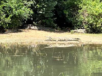
I photographed this scene in October 2024, on the route toward the park — one of twelve days I spent travelling through Uganda that month. That same week, our boat moved slowly across the Nile inside Murchison Falls National Park while a massive Nile crocodile rested on the far bank, half in, half out of the water. The distance between us and the animal was considerable, yet the impression it left was not. These are not small predators. They move with a speed and decisiveness that is hard to appreciate until you have seen them close to, even from a boat. That stretch of river — between the falls and Lake Albert — is one of the densest crocodile habitats in East Africa, and the animals are a visible reminder that the aquatic ecosystems of this region remain genuinely intact in ways that are rare on this continent.
That intact quality does not come by accident. Uganda has made deliberate legal and conservation investments in its water systems, and the wetlands that connect its rivers and lakes to human communities are at the centre of those efforts. Twelve sites in Uganda now carry Ramsar designation — internationally recognised wetlands of importance. What that means in practice, what threatens them, and how Lake Victoria sits at the intersection of all of it is the subject of this article.
What Uganda's 12 Ramsar Sites Actually Protect
The Ramsar Convention on Wetlands of International Importance provides an international framework under which governments designate specific wetland sites as globally significant. Uganda currently holds 12 Ramsar-listed sites. These include well-known visitor destinations such as Bigodi Wetland Sanctuary in western Uganda and Mabamba Bay Swamp on the northern shore of Lake Victoria, as well as less-visited sites that serve critical ecological functions without attracting significant tourist attention.
Together, Uganda's Ramsar sites form the most protected tier of a much wider wetland network. Wetlands cover approximately 13% of Uganda's total land area, according to the National Status of the Environment Report 2024 (NSOER 2024), with that percentage distributed across lake shores, river valleys, papyrus swamps and seasonally flooded grasslands. The Ramsar sites represent the internationally agreed best of this network — the wetlands where biodiversity value, ecological function, and cultural significance have been formally verified and inscribed.
Bigodi Wetland Sanctuary is probably Uganda's best-known community-managed Ramsar wetland. It sits adjacent to Kibale National Park in western Uganda, managed by the Kibale Association for Rural and Environmental Development (KAFRED). Bigodi is notable for primate diversity — red-tailed monkeys, grey-cheeked mangabeys, and the L'Hoest's monkey are all regularly encountered — and for its bird life, with over 200 recorded species. The community management model here is significant: revenues from visitor fees remain within the community, creating a direct economic relationship between wetland conservation and local livelihoods.
Mabamba Bay Swamp occupies a different position in Uganda's wetland network. It lies directly on Lake Victoria's northern shoreline, making it both a wetland and a coastal system. It is, in practical terms, the most reliable site in East Africa for encountering the shoebill stork (Balaeniceps rex) — a prehistoric-looking bird with no close relatives that nests in undisturbed papyrus swamps. Guided boat trips operate from the Mabamba landing site, accessible from Entebbe in roughly 45 minutes. The wetland also supports sitatunga antelope and numerous fish species that migrate between the papyrus roots and the open lake. For visitors based in Entebbe or Kampala, it is among the most accessible genuine wildlife experiences available in Uganda.
What Threatens Uganda's Wetlands — and Why Lake Victoria Is Central
Uganda is losing wetlands at a rate of approximately 5,000 hectares per year, according to NSOER 2024 data. This is not a sudden emergency but a slow attrition driven by agriculture, urban expansion, drainage for development, and the encroachment of settlements onto seasonally flooded land that was previously left unoccupied. The cumulative effect over decades has been substantial. Areas that once served as natural water filters, fish nurseries, flood buffers and carbon stores have been converted to farms, housing and roads.
The relationship between Kampala's wetlands and Lake Victoria illustrates this problem in concentrated form. According to the 2018 Multi-Hazard Risk and Vulnerability Profile, wetlands cover 18.68 square kilometres of Kampala's total area — approximately 8.95% of the city. These are not decorative features. They are natural extensions of the lake's aquatic ecosystem, functioning as transition zones between urban land and open water. When medical waste, non-biodegradable rubbish and industrial effluent are deposited in these wetland areas — as the 2018 profile documents happens — the contamination pathway leads directly toward Lake Victoria's northern shore.
Kampala generates approximately 65% of Uganda's national GDP, concentrating both economic activity and waste production in the area closest to the lake. The Waste Management Regulations (S.I. No. 49 of 2020) — which run to 109 separate regulations and 16 schedules — are Uganda's primary legislative response to this challenge. They establish a 500-metre buffer zone within which hazardous waste disposal is prohibited near wetlands. The enforcement of this buffer, alongside the broader framework for industrial waste management, is identified in the 2018 Multi-Hazard Risk profile as one of the recommended strategies for protecting Kampala's wetland system.
For visitors arriving at Entebbe Airport and driving north toward Kampala, the wetland fringes of Lake Victoria are visible from the road — flat papyrus margins between the lake and the rising city. What is less visible is the pressure those margins are under. The enforcement of wetland protection laws in an urban context where land is both expensive and politically contested requires continuous institutional attention.
The Nile Perch Problem: From Triumph to Overexploitation
The story of Nile perch in Lake Victoria is one of the most documented examples of ecological disruption caused by a single introduced species. Lates niloticus was deliberately introduced into the lake in the 1950s — the exact dates and locations of introduction are still disputed in the scientific literature — with the stated intention of improving the productivity of the commercial fishery. What followed was an ecological cascade that reshaped the lake's biodiversity over the following three decades.
Lake Victoria was home to an extraordinary assemblage of cichlid fish — predominantly haplochromine species — numbering in the hundreds of distinct forms, many of them endemic to the lake. The introduction of a large, fast-growing, highly predatory fish into a system that had never experienced such a predator removed those cichlids from large parts of the lake within a generation. Estimates of species loss range from 200 to over 400 cichlid species, making it one of the largest documented vertebrate extinction events of the 20th century. The loss of cichlids also disrupted the feeding relationships that cichlids had maintained — including algae control, insect larva consumption, and mollusc predation — in ways that contributed to the subsequent water hyacinth explosion and eutrophication problems.
At the same time, Nile perch created a major commercial fishery. The fish can grow to over 100 kilograms, has white, firm flesh that exports well, and was quickly processed by a network of lakeside factories that shipped fillets to European markets. For decades, Nile perch was Uganda's most valuable agricultural export by weight, and the fishing industry around Lake Victoria employed hundreds of thousands of people. The fish that destroyed much of the lake's endemic biodiversity simultaneously became the foundation of an export economy.
That economy is now under pressure from the same extractive logic that shaped it. Uganda's NSOER 2024 identifies overexploitation and size-structure problems as central threats to the current Nile perch fishery. "Size-structure problems" refers to a specific and well-understood dynamic in overexploited fish populations: fish are being caught before they reach reproductive maturity, which reduces the breeding population faster than natural replacement can compensate. Over time, average fish size declines, catch volumes fall despite stable or increasing fishing effort, and the population becomes increasingly vulnerable to collapse.
What Uganda's Fisheries Act 2022 Changes
The Fisheries and Aquaculture Act 2022 is Uganda's legislative response to documented overfishing pressure across the country's major water bodies, including Lake Victoria. It replaces earlier fisheries law with a more comprehensive framework that addresses not only harvest regulation but also biodiversity protection, community-based fisheries governance, and aquaculture development.
On the commercial side, the Act provides the legal basis for minimum size limits, gear restrictions, and seasonal closures intended to allow juvenile fish to reach reproductive maturity before capture. On the aquaculture side, it creates a licensing framework for cage fish farming operations — tilapia cage culture has expanded significantly on Lake Victoria in recent years — with environmental compliance requirements for larger operations. Facilities producing 200,000 kilograms per year or occupying more than one hectare are required to undergo environmental compliance audits under Uganda's audit regulations (S.I. No. 47 of 2020).
The National Fisheries Resources Research Institute (NAFIRRI), based in Jinja at the lake's outlet, provides the scientific monitoring foundation for fisheries management decisions. NAFIRRI has conducted regular stock assessments of Lake Victoria's commercial fish species for decades, and its data feeds directly into both national policy and the shared management framework maintained by the Lake Victoria Fisheries Organisation (LVFO), which coordinates fisheries governance across the three riparian states of Uganda, Kenya and Tanzania.
Integrated Water Resources Management and What It Means for Lake Victoria
Beyond wetland boundaries and fisheries legislation, Uganda has committed to a framework known as Integrated Water Resources Management (IWRM). This approach treats water not as a commodity to be extracted from one source or another, but as part of an interconnected system — groundwater, surface water, wetlands and rainfall all feeding the same hydrological cycle, subject to the same pressures, and requiring coordinated management.
For Lake Victoria, IWRM matters because the lake does not receive its water from a single river. It is fed by hundreds of small streams and seasonal watercourses flowing from Uganda's central plateau, as well as by direct rainfall on the lake's surface — rainfall that has itself become less predictable as climate variability increases. The wetlands that border the lake, including Uganda's Ramsar sites, are part of this catchment system. When they are drained or degraded, the filtering and buffering functions they perform are lost, and water quality in the lake deteriorates accordingly.
The IWRM framework identifies pollution — particularly from agricultural runoff carrying fertilisers and pesticides, and urban waste from Kampala's inadequately served informal settlements — as the primary water quality threat to Lake Victoria's northern basin. In Kawempe Division alone, 8 of Kampala's 31 documented informal settlement areas are located in lowland and wetland zones, according to the 2018 Multi-Hazard Risk profile, placing both residents and the lake's catchment under simultaneous pressure.
Water hyacinth remains a visible indicator of this pressure. The floating plant — introduced accidentally into African waterways in the late 20th century — thrives in nutrient-enriched water and has at various points covered large areas of Lake Victoria's surface, particularly near Kampala's Ggaba, Salama and Buziga shoreline and around Luzira in Nakawa Division. Biological control using the weevil Neochetina has had documented success in reducing hyacinth cover, but the plant rebounds wherever nutrient enrichment from urban runoff continues. Managing it without addressing the nutrient source is an indefinitely recurring task.
Tourism, Environmental Compliance, and What Visitors Should Know
Uganda's National Environment (Audit) Regulations (S.I. No. 47 of 2020) require that lodges, luxury camps, hotels, resorts and beach facilities located near wetlands, wildlife conservation areas or forest reserves undergo environmental compliance audits. These audits must be renewed every three years, along with updated environmental management and monitoring plans. This is not a minor administrative requirement — it applies directly to the tourism facilities most likely to be visited by anyone planning a trip to Lake Victoria or the Ramsar wetland sites.
For visitors, this regulatory framework offers practical guidance on what responsible tourism looks like on the ground. Choosing operators that hold current compliance certification is one concrete action. Visiting conservation-purpose sites — Mabamba Bay for the shoebill, Ngamba Island Chimpanzee Sanctuary via Entebbe, Bigodi Wetland near Kibale — generates direct revenue for conservation management rather than simply extracting an experience from a landscape. Disposing of waste responsibly matters more on small island or wetland sites where no waste collection infrastructure exists.
The introduction of new species into conservation areas requires an environmental compliance audit under S.I. No. 47 of 2020 — a detail that underscores how seriously Uganda's legal framework takes the kind of ecological disruption that followed the Nile perch introduction. Whether enforcement matches that legal ambition in every case is a separate question, but the framework itself reflects an understanding of what went wrong in the past.
[QUOTE: local guide on the difference between Mabamba Bay today and twenty years ago]
During my time in Uganda in October 2024 and January 2026 — twelve days and eleven days respectively — the pattern that emerged most consistently was the contrast between the scale of the conservation challenge and the resilience of the natural systems themselves. The crocodiles in Murchison Falls National Park were thriving. The birdlife along Lake Victoria's shoreline was audible before it was visible. The Ngamba Island chimps, which I visited in October 2024, moved with a confidence in their forested sanctuary that took time to earn. These are not fragile remnants of a lost landscape. They are systems under pressure that have not yet broken, and that have legal frameworks, community interest and international attention working to keep them intact. That combination is worth visiting to understand — and worth supporting to sustain.
Explore Further
Frequently Asked Questions
How many Ramsar wetland sites does Uganda have?
Uganda has 12 Ramsar-listed wetland sites designated under the Convention on Wetlands of International Importance. These include Bigodi Wetland Sanctuary near Kibale Forest and Mabamba Bay Swamp on Lake Victoria's northern shore, among others. Together they sit within Uganda's wider wetland network, which covers approximately 13% of the country's total land area according to the NSOER 2024.
What is Bigodi Wetland Sanctuary in Uganda?
Bigodi Wetland Sanctuary is a community-managed Ramsar wetland adjacent to Kibale National Park in western Uganda. It is known for primate and bird diversity, including red-tailed monkeys, grey-cheeked mangabeys and over 200 bird species. The sanctuary is managed by KAFRED (Kibale Association for Rural and Environmental Development), which directs visitor revenues back into the local community.
What happened to Nile perch in Lake Victoria?
Nile perch was introduced into Lake Victoria in the 1950s and contributed to the collapse of hundreds of endemic cichlid species. While the fish initially created a major export fishery, catches have declined due to overexploitation. Uganda's NSOER 2024 identifies unsustainable exploitation rates and size-structure problems — fish caught before they can reproduce — as key threats to the long-term viability of the Lake Victoria Nile perch fishery.
What does Uganda's Fisheries Act 2022 do?
Uganda's Fisheries and Aquaculture Act 2022 governs fishing and aquaculture across all of Uganda's water bodies. It establishes the legal framework for sustainable fisheries management, biodiversity protection, community-based governance and aquaculture licensing. The Act responds directly to documented overfishing pressures on Lake Victoria and replaces older fisheries legislation that did not address current scale and intensity of exploitation.
Can visitors see wetlands near Lake Victoria in Uganda?
Yes — Mabamba Bay Swamp on Lake Victoria's northern shore is one of the best wetland visitor experiences in Uganda and the most reliable site in East Africa for the shoebill stork. Guided boat trips depart from the Mabamba landing site, reachable from Entebbe in around 45 minutes. The wetland is part of Uganda's Ramsar network and supports papyrus-nesting birds, sitatunga antelope and multiple fish species connected to the lake.