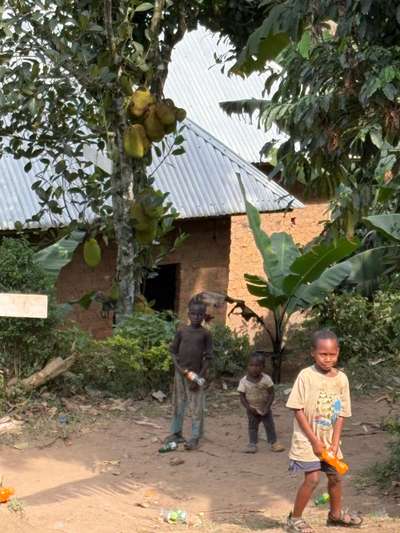
Three children were standing just outside the fence when we arrived at the Buhoma orphanage in June 2026. They were shy — hanging back rather than stepping forward — and it was immediately apparent that things were not going well for them. Their clothes were worn, their manner subdued in a way that went beyond simple shyness. These were children from the surrounding neighbourhood, not residents of the orphanage itself, but drawn to its vicinity as children in difficult circumstances often are: by proximity to a place where meals happen and adults pay attention. We invited them to eat with us without deliberation. What happened next was quiet and unremarkable and, in its quietness, entirely the point. GPS-verified photographs taken at -0.9617°N, 29.6109°E on 21 June 2026 document this moment: three children, a simple building with a corrugated iron roof, a patch of red Uganda earth.
Buhoma sits at the northwestern edge of Bwindi Impenetrable National Park in southwestern Uganda, at an elevation where the temperature is noticeably cooler than the lowlands around Lake Victoria, three hundred kilometres to the east. It is the starting point for gorilla trekking in the Buhoma sector of the park — one of the four sectors from which habituated mountain gorilla families can be visited — and it is, simultaneously, a village with its own economy, its own social fabric, its own particular difficulties. Visitors arrive here for the gorillas. What they encounter, if they pay attention, is a community navigating the gap between a conservation success story and the ordinary texture of life on very limited income in a remote corner of the country.
This article draws on multiple visits to the Bwindi and Buhoma area across an extended period, including a twelve-day stay in October 2024, an eleven-day visit in January 2026 with Susanne Suer, and a June 2026 return documented in three GPS-tagged photographs taken within a four-minute window between 06:32 and 06:36 on 21 June 2026. The cumulative time spent in and around Buhoma across these visits runs to many weeks — enough to see how the village changes between tourist seasons, what the orphanage's relationship with the surrounding community actually looks like, and how the gorilla trekking industry connects to the lives of people who live in the forest's shadow rather than passing through it as visitors.
Bwindi Impenetrable National Park: Orientation
Bwindi Impenetrable National Park covers approximately 331 square kilometres of montane and lowland forest in southwestern Uganda's Kigezi highlands, straddling the border with the Democratic Republic of Congo. The park takes its name from the density of its vegetation: bwindi is a Rukiga word meaning dark or impenetrable, and the forest justifies the description. Even on the main tracks between sectors, the canopy closes overhead and the undergrowth crowds the path. Moving off the established routes requires a guide with a machete and a reasonable tolerance for steep, slippery terrain.
The park was gazetted in 1991 and designated a UNESCO World Heritage Site in 1994, primarily on the strength of its mountain gorilla population. At the time of the most recent comprehensive census — covering the 2018–2020 period — Uganda's mountain gorilla population stood at approximately 459 individuals across the Bwindi and Mgahinga populations, a number that represents a significant recovery from the critically low counts recorded in the 1980s. The recovery is generally attributed to the combination of sustained anti-poaching enforcement, the habituation programme that made gorilla trekking economically viable, and the income from trekking permits that funds conservation operations and provides employment in the surrounding communities.
The four trekking sectors are distributed across the park's geographical spread: Buhoma in the north, Ruhija in the east, and Rushaga and Nkuringo in the south. Each has habituated gorilla families allocated to daily trekking permits, with a strict limit of eight permits per family per day. The sectors have somewhat different characters — Buhoma is the most established and most accessible from Kampala; Rushaga in the south offers multiple families and is popular for habituation experience visits; Ruhija is the least visited and offers a different forest character. Most visitors choose based on logistics rather than detailed comparison.
Gorilla Trekking in the Buhoma Sector: What to Expect
The gorilla trekking day in the Buhoma sector begins at the park headquarters with a briefing: rules of engagement with the gorillas, what to do if a silverback charges, how to move in the forest, why eight visitors per family per day is the enforced limit. Two rangers accompany each group — both armed, standard practice across all sectors — along with a guide. The rangers' presence at the start seems official and perhaps slightly incongruous; by the time the group reaches the gorillas an hour or two into the forest, their role has clarified itself into something practical: they know the terrain, they track the family's daily movements, and in the dense vegetation, they are the reason the group finds the gorillas at all rather than spending the permitted hour searching.
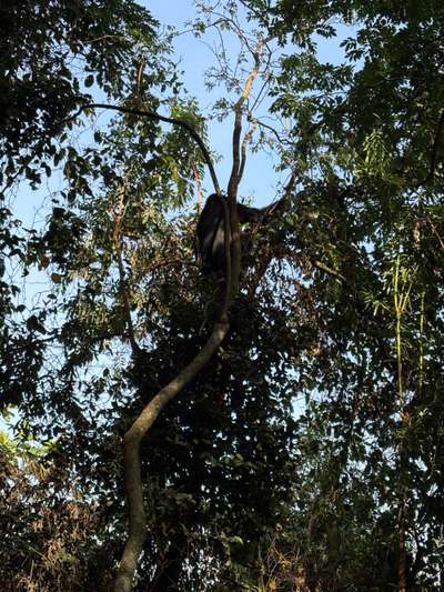
During the January 2026 trekking visit, the first gorilla of the day was encountered after approximately one hour of walking — a single animal sitting in the high branches of a large tree, feeding on leaves. This detail matters: the expectation before a first gorilla trek is often that the encounter will be on the forest floor, face to face. In practice, gorillas spend significant time in tree canopies, particularly when feeding, and the first visual is often upward — a large dark shape among branches, moving with a deliberateness that makes the size of the animal immediately apparent even at height. The photograph taken at GPS -0.9735°N, 29.6281°E captures this moment: the animal in the canopy, leaves in its hands, apparently entirely uninterested in the group watching from below.
The one-hour limit with the gorilla family passes faster than any trekker expects. The encounter is governed entirely by the animals: they move, the group follows at a respectful distance; they settle, the group watches. The rangers position visitors and enforce the seven-metre minimum distance, though in practice the gorillas themselves sometimes close this gap without invitation — juveniles in particular are curious about the group and have been habituated sufficiently to approach. When a juvenile comes within a metre of a visitor's boot, the guide gestures people back, quietly and without drama. The rules exist because the gorillas are susceptible to human respiratory diseases, and maintaining distance protects the population that the entire trekking programme depends on.
The return journey to the trailhead — downhill, on the same or a parallel route — typically takes less time than the ascent, partly because the terrain is easier going down and partly because the group is moving purposefully rather than tracking. Guides and rangers complete this section efficiently; the visitors follow at whatever pace their legs allow after the morning's effort.
Permit Costs and Booking
Gorilla trekking permits for foreign non-residents are priced at USD 800 per person (Uganda Wildlife Authority rate — verify before booking, as pricing is periodically revised). Foreign residents of East Africa pay USD 600; Ugandan citizens pay UGX 250,000. Permits cover the one-hour encounter with the gorilla family, the guide and ranger services, and park entry for the day. They do not include accommodation, transport to the park, or tips. Permits must be booked through UWA or an accredited operator; availability in peak months (July–August, December–January) is limited and sells out well in advance. The low season — April, May, and November — historically offered reduced pricing for these months, though rates and eligibility should be confirmed with UWA at time of booking.
The strict permit limit of eight visitors per family per day is not simply a regulation: it is the mechanism that makes the entire conservation economy function. More visitors would mean more income, but it would also mean more disturbance, more disease risk, and the degradation of the encounter quality that sustains the premium price. The limit has held since the trekking programme was established, and it is the reason a Bwindi gorilla permit costs what it costs — scarcity, combined with an experience that nothing else replicates, produces a price that funds conservation, employs rangers and guides, and generates the community development income that makes local communities stakeholders in the gorillas' survival rather than competitors for their habitat.
Buhoma Village and the Community Around the Park
The relationship between Bwindi National Park and the communities that surround it is not simple, and it was not always amicable. Before the park was gazetted in 1991, the forest was used by local communities for firewood, building materials, hunting, and cultivation. Gazettement ended most of these uses, creating a boundary where none had existed and displacing economic activities onto already limited agricultural land outside the park. The communities most affected were the Batwa — a forest-dwelling people whose entire livelihood system depended on access to the forest — and the Bakiga and Bafumbira agricultural communities along the park's edge.
The community revenue-sharing system introduced alongside the trekking programme addressed part of this grievance: a proportion of permit income is allocated to community development projects in the surrounding area. Schools, health facilities, and infrastructure projects in Buhoma and other communities around the park's perimeter have been funded through this mechanism. The system is not without its critics — disputes about equitable distribution, the extent to which income reaches the most marginalised community members, and the adequacy of the share relative to the restrictions on forest access are genuine and ongoing — but it represents a more sophisticated attempt to align conservation with local economic interest than the pure exclusion model that preceded it.
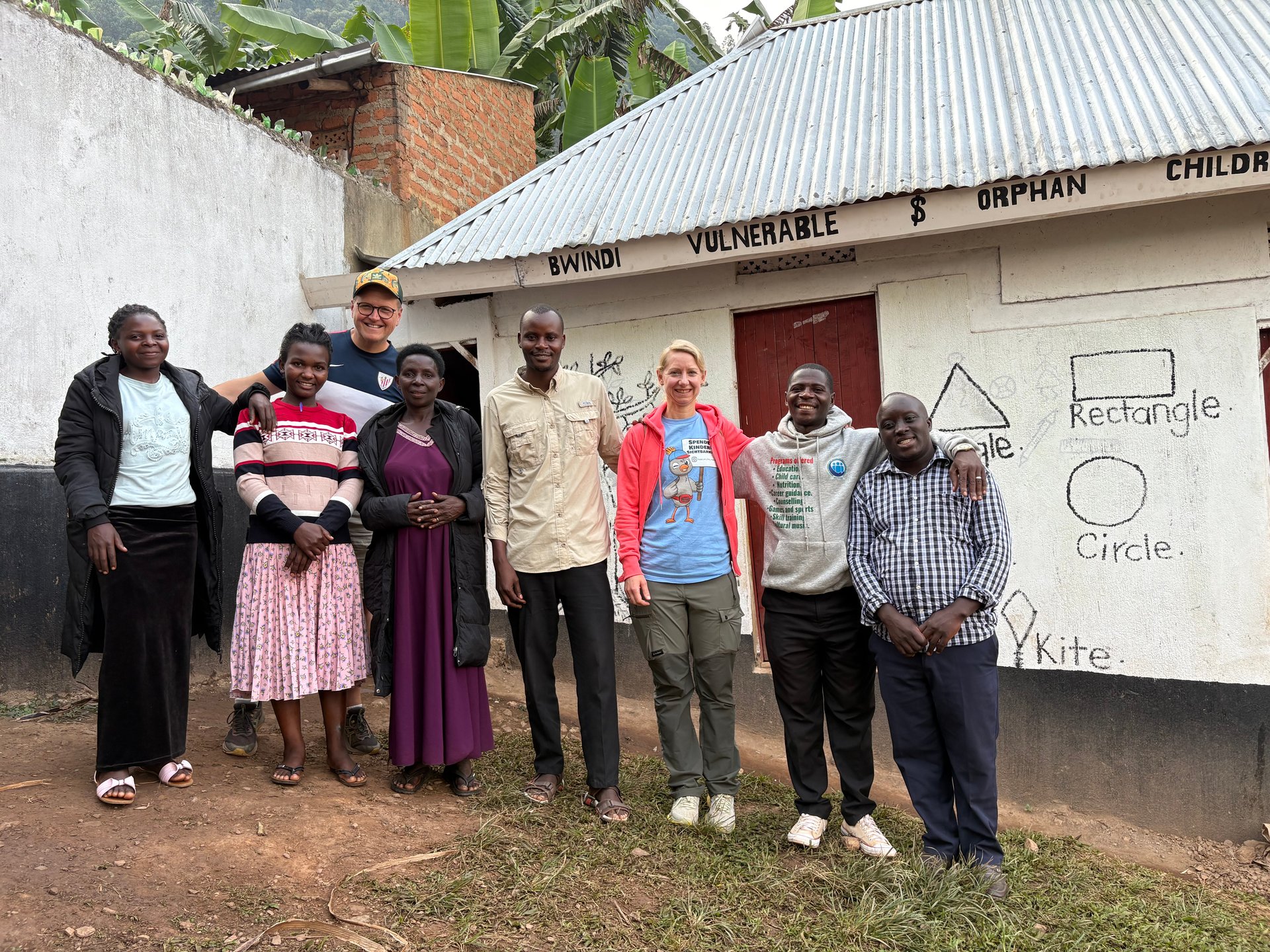
What is visible in Buhoma itself — observed across multiple visits between October 2024 and June 2026 — is a small commercial settlement serving the trekking industry: lodges of varying quality, a few restaurants and shops, community craft enterprises, and a flow of tourists during the busier months that creates real economic activity. The community development projects are visible in the school buildings and the health facility. Less visible, but present, are the households that benefit little from the trekking economy — subsistence farmers on the hillsides above the village, people without the skills or connections to enter the tourism employment market, children whose families are not positioned to benefit from the community development investments. The orphanage and its neighbourhood represent this less visible stratum.
[QUOTE: local guide or community member in Buhoma on the changes over the past decade — collect on next visit]
The Batwa and Forest Displacement
The Batwa — sometimes called Twa, and sometimes referred to by the derogatory term "pygmies," which they generally reject — were the original forest-dwellers of Bwindi and the broader Albertine Rift region. Their displacement following the park's gazettement has been one of the most discussed controversies in African conservation, cited as a case study in the human cost of conservation models that prioritise wildlife over the rights of forest-dependent peoples.
Batwa communities now live primarily outside the park boundary, on land that was not traditionally theirs and without the forest skills and practices that formed the basis of their culture. Land holdings are generally small, agricultural productivity is limited by both land quality and the mismatch between Batwa cultural knowledge and sedentary farming, and poverty rates among Batwa households are substantially higher than among their agricultural neighbours. Several NGOs and community organisations operate programmes specifically targeting Batwa welfare in the Bwindi area, with mixed results. Some trekking operators include Batwa cultural experience visits as part of a Bwindi itinerary, with income going to Batwa community funds — an imperfect but practical mechanism for channelling some tourism income to a community that has received relatively little of it.
Southwest Uganda: The Lake Victoria Circuit Connection
Bwindi and Buhoma are located roughly 500 kilometres southwest of Kampala by road — a journey of eight to ten hours on the main route via Mbarara and Kabale, or slightly shorter via the more mountainous route through Bwindi from the south. The distance means that most international visitors combine southwest Uganda with the broader Uganda itinerary rather than making it a standalone destination. The usual circuit begins and ends at Entebbe International Airport on the shores of Lake Victoria: arrivals, days in Kampala or on the lake, then travel west to the primate destinations — Kibale Forest (chimpanzees), Queen Elizabeth National Park (tree-climbing lions), and Bwindi — before returning to Entebbe for departure.
Lake Victoria is thus the geographical frame through which most Bwindi visitors enter and exit Uganda. Entebbe, sitting at 1,136 metres on the lake's northern shore, is where the altitude begins and the equatorial climate becomes tangible: warm but manageable, the lake visible from the airport approach. Buhoma, at roughly 1,700 metres in the Kigezi highlands, is a different climate entirely — cool mornings, afternoon mists, the kind of temperature that makes a jacket useful even in June when the lowlands are humid and warm.
For visitors planning a Uganda itinerary that includes both Lake Victoria and southwest Uganda, the logistics require some attention. The distance and road quality between Kampala and Buhoma mean that flying — to Kihihi airstrip near Bwindi, served by charter operators from Entebbe and Kajjansi — is a realistic option for those with limited time. The road journey, while long, passes through some of Uganda's most varied landscapes: the flat agricultural land around Masaka, the rolling tea hills of Bushenyi, the dramatic escarpment above Kabale, and the narrowing mountain roads toward Bwindi itself. Travelling by road in the company of a knowledgeable guide produces a different kind of Uganda education than flying directly to the park gate.
Kabale as the Regional Hub
Kabale, approximately 80 kilometres south of Bwindi, serves as the practical staging town for visitors to the southwest circuit. At roughly 1,900 metres elevation, it is one of Uganda's highest towns and has a noticeably different character from the lowland cities: cooler, quieter, with a compact commercial centre built for the local agricultural economy as much as for tourism. Several mid-range hotels in Kabale offer gorilla trekking coordination services and can arrange permits, transport, and onward logistics. Lake Bunyonyi, eight kilometres west of Kabale, is among Uganda's most scenic destinations — a deep crater lake at 1,962 metres surrounded by terraced hills, with several island resorts accessible by canoe or motorboat. Many visitors break the journey to or from Bwindi with a night or two at Lake Bunyonyi.
Practical Information for Bwindi and Buhoma Visitors
Getting there. The main road route from Kampala runs south via Masaka and Mbarara, then southwest to Kabale and on to Buhoma. Journey time from Kampala to Buhoma is typically eight to ten hours in a well-maintained vehicle. The final stretch from Kabale to Buhoma is on unpaved roads that require a 4WD, particularly in the wet season. Charter flights to Kihihi airstrip (approximately 35 km from Buhoma) are available from Entebbe and Kajjansi; flight time is under an hour.
When to visit. The dry seasons — June to September and December to February — offer the most reliable trekking conditions. Paths are less slippery, the forest is easier to navigate, and rain interruptions during the trek are less common. The wet seasons (March to May, October to November) see heavier rainfall that makes the steep forest paths genuinely difficult and can reduce visibility in the forest. The January 2026 visit was made in the early dry season, and trail conditions were good throughout. The June 2026 visit confirmed that the early dry season offers excellent conditions with comfortable temperatures in the Buhoma area.
It is worth noting that even in the dry season, Bwindi can receive unexpected rain at altitude — the forest creates its own microclimate, and morning conditions can shift in the afternoon. Waterproof gear and gaiters are useful throughout the year regardless of the official season.
Accommodation. Buhoma has a range of accommodation from basic community guesthouses to established mid-range lodges. Properties near the park gate — Buhoma Lodge, Bwindi Lodge, and several community-run guesthouses — offer direct access to the briefing point without additional driving. Luxury properties at higher price points are available both in Buhoma and in other sectors of the park, but the character of Buhoma itself — a functioning village, not a resort enclave — means that even the mid-range options have an authentic local setting. Visitors who engage with the village rather than retreating entirely to their lodge tend to come away with a more complete understanding of what the park's existence means to the people around it.
Beyond the gorilla trek. The Bwindi area offers several activities beyond the one-hour gorilla encounter. Forest walks with rangers and naturalist guides cover the park's biodiversity — more than 350 bird species have been recorded in Bwindi, making it one of Africa's most important birding destinations, and the forest's primate community extends beyond gorillas to include chimpanzees, black-and-white colobus, l'Hoest's monkey, and others. Community walks in Buhoma visit local craft producers, the community-run Batwa cultural programme, and agricultural homesteads. These activities extend what would otherwise be a purely transactional visit — arrive, trek, depart — into something that gives the community more economic benefit and the visitor more context.
The community orphanage in Buhoma operates as part of this wider social infrastructure — a place that addresses one of the consequences of the economic and social conditions in which the village exists, funded by a combination of international donors and local community support. The children encountered outside its fence in June 2026 were from the neighbourhood rather than residents of the facility itself, which is itself a reminder of how much need exists beyond the direct catchment of any single programme. Direct local support — buying food from community producers, eating at locally owned restaurants, employing local guides rather than operators based in Kampala — is the most immediate mechanism by which visitor spending reaches the households that the trekking economy's formal revenue-sharing does not easily reach.