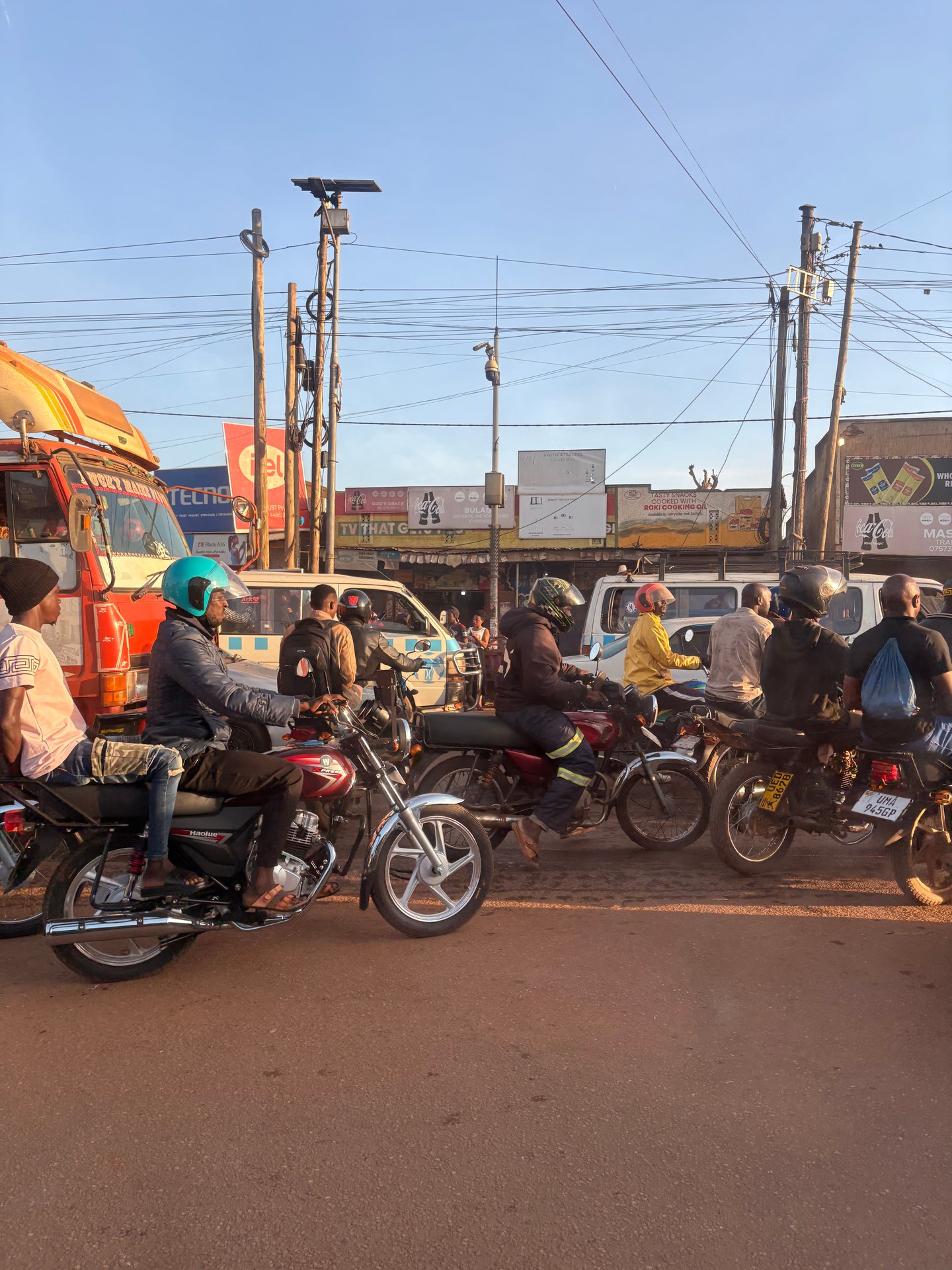
Arriving in Kampala from Entebbe airport, the city introduces itself without preamble. From the back seat of the safari jeep that collected us from the terminal in January 2026 — a roof-racked 4WD of the kind that defines Ugandan overland travel — the first twenty minutes of driving through the capital delivered a concentrated education in how this city actually moves. The roads were dense with vehicles in both directions, but more than that, they were dense with motion at every scale simultaneously: lorries inching forward, minibuses pulling up without warning, pedestrians cutting diagonally across four lanes, cyclists threading gaps that appeared and closed within seconds. And everywhere, in numbers that took a moment to fully register, the bodaboda riders.
Bodaboda motorcycles are the connective tissue of Kampala's transport system, and arguably of Uganda's entire informal mobility network. During three separate visits — October 2024, January 2026, and May 2026 — Mark Suer photographed Kampala's streets from multiple vantage points, accumulating eight GPS-tagged images that document the city's transport character across different seasons and times of day. The GPS coordinates 0.2917°N and 0.2918°N at 32.4996°E, recorded on the May 2026 images, place the photographs squarely in Kampala's busy central approach roads. What they show is not disorder, on closer examination, but a highly adapted system operating under its own logic — one that the city's formal infrastructure has never fully replaced and may never need to.
The roadside, as observed repeatedly on these visits, is not simply the edge of the road. It is a continuous commercial zone. Small stands selling phone credit, roasted groundnuts, bottled water, vegetables, second-hand clothing, and cooking fuel line every arterial road in the city. Some are permanent structures of wood and corrugated iron; others are mobile operations — a person with a tray balanced on their head, moving through stationary traffic with practiced ease. The street in Kampala is not a transport corridor with occasional commerce at its margins. It is a marketplace that happens to accommodate vehicles.
What is a Bodaboda?
The word bodaboda comes from the English phrase "border to border" — a reference to the motorcycle taxis that originally operated between the formal border posts of Uganda and Kenya, carrying passengers and goods across the gap that larger vehicles could not easily cover. The name stuck long after the practice generalised across the entire country, and today bodaboda refers to any motorcycle taxi operating in Uganda, whether in the capital's dense traffic or on rural tracks where no other motorised transport runs.
As a mode of transport, the bodaboda occupies a position that no other vehicle in Uganda can match for flexibility. It can go where matatu minibuses cannot, can move where private cars are gridlocked, and can carry a remarkable range of cargo beyond its nominal function as a people-mover. On the October 2024 journey from Kampala's outskirts toward the north, a bodaboda was photographed at GPS coordinates 1.0033°N, 32.1059°E carrying multiple large water canisters — jerry cans of the kind used for water storage in areas without piped supply. The rider was helmetless, wearing sandals, moving at a steady pace along the road with a load that would be categorically illegal in most European countries. In Uganda, it is simply how water gets from where it is available to where it is needed, using the most flexible vehicle available.
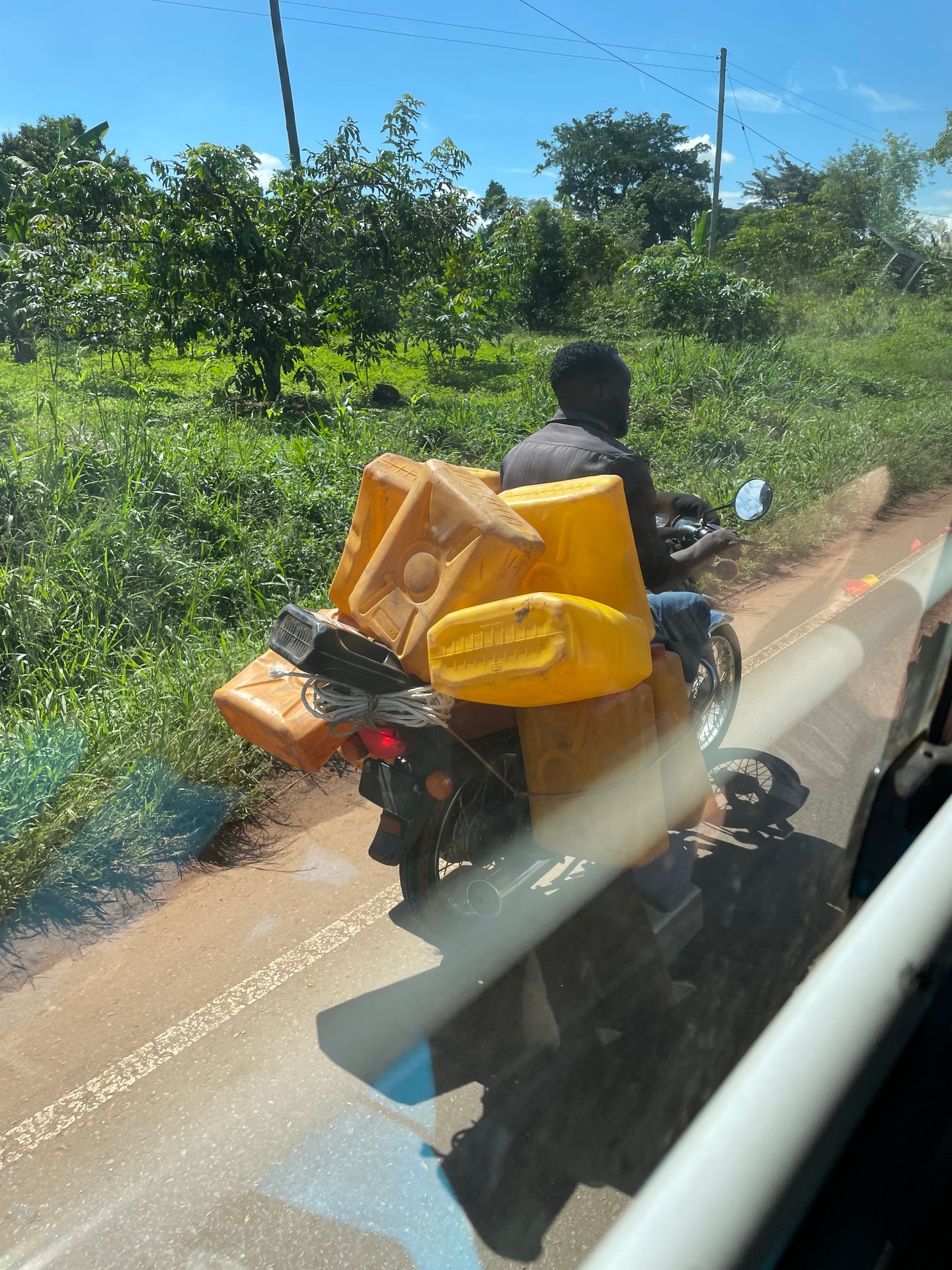
The water canister image is striking to a European eye because it combines several things that would each individually trigger a regulatory response in a Western city: no helmet, no footwear appropriate for a motorbike, an oversized unstable cargo, a vehicle not rated for this kind of load. But the framing "would not be allowed in Europe" misses the point entirely. The bodaboda rider with water canisters is not breaking rules that exist and are being ignored. He is filling a supply function that no formal infrastructure currently performs. The water needs to move. He has the vehicle and the route knowledge. The transaction happens. This is the informal economy operating at the precise point where formal systems stop, which in Uganda, as in much of sub-Saharan Africa, is a very long way from where the need ends.
For Lake Victoria specifically, this dynamic is directly relevant. The lake's shoreline communities — fishing villages, landing sites, small urban settlements along the northern and western shores — depend on this kind of flexible informal logistics for everything from fish distribution to building materials to the water supplies that formal municipal systems do not yet reach. The bodaboda is not incidental to the Lake Victoria economy. It is one of its primary arteries.
Kampala's Informal Economy: The Street as Marketplace
To understand Kampala's street economy requires first setting aside the assumption that informality represents a failure of formal systems to reach their natural endpoint. The density of small commercial operations along Kampala's main roads — observed consistently across the October 2024, January 2026, and May 2026 visits documented here — is not a transitional state the city is growing out of. It is a stable, adaptive economic structure that has co-existed with the city's formal economy for generations and shows every sign of continuing to do so.
The stands and small shops that line Kampala's arterial roads serve a population that does not shop in the way that supermarket retail assumes. Purchases are small, frequent, and made close to home or close to work rather than consolidated into weekly shopping trips by car. The person who stops to buy a handful of tomatoes, three eggs, and a sachet of cooking oil on the way home from work is not making an inferior version of a supermarket shop. They are making a purchase that precisely matches their cash flow and storage capacity: small amounts at a time, because that is what the budget allows and the kitchen can hold. The street market is not a workaround. It is the appropriate form for the transaction.
The photography from the January 2026 and May 2026 Kampala visits captures this at two slightly different GPS coordinates — 0.2833°N, 32.4561°E in January and 0.2917–0.2918°N, 32.4996°E in May — on different sections of the same city's road network, and the character is consistent across both: dense traffic, continuous roadside commerce, bodaboda riders threading through every available gap, minibuses stopping and starting. The visual impression from inside a vehicle is one of controlled chaos. From outside — which is to say, from the perspective of the people living and working in that space — it is simply the normal operational state of the city.
The Matatu Network
Alongside the bodaboda, the matatu — shared minibus taxi — forms the backbone of Kampala's public transport. Matatus operate on informal routes throughout the city, with fares negotiated or understood from experience rather than posted on a board. They load and unload passengers at the roadside, at formal taxi parks, and at any point along the route where a passenger signals. The two main taxi parks in central Kampala — Old Taxi Park and New Taxi Park — are the hubs from which routes radiate outward across the city and, for longer-distance services, toward the rest of Uganda.
For visitors arriving at Entebbe airport and heading to Kampala, the matatu is the budget option: a vehicle departs from outside the terminal building and runs to Kampala's central taxi parks, where onward connections are available. The journey is slower than a private transfer, more stops are made, and the vehicle will be full. But it is a direct window into how the city's majority actually moves, and for visitors willing to manage their luggage in a crowded vehicle, it is a legitimate choice. From the taxi park, further matatus or bodaboda rides can take a passenger to any part of the city.
The KCCA's ongoing infrastructure investment includes plans for two dedicated bus parks and truck terminals along main arterial roads, with a combined budget of UGX 18 billion (KCCA Strategic Plan 2025). At present, the loading and unloading of matatus and long-distance buses happens in the roadway itself — pulling over to the kerb, or in some cases stopping in a live lane — which is a significant contributor to the traffic congestion that makes Kampala's roads slow at peak hours. Dedicated terminals that remove this activity from the road surface would produce measurable improvement, though the scale of the challenge is substantial: the city's entire culture of roadside commerce and informal transport operation has grown up around the current arrangement, and formalising the stops is not simply a question of building infrastructure.
Driving Through Kampala: What to Expect
For visitors transiting Kampala — arriving from Entebbe or passing through on the way to safari destinations to the north, west, or southwest — the practical experience of the city's roads is worth understanding before rather than during the journey. Three visits across different months, documented with GPS-tagged photography, provide a consistent picture.
The traffic in Kampala is dense at most hours of the working day, and very dense during morning and evening peak periods. The city sits on a series of hills, and the road network was not originally designed for the volume of vehicles it now carries. Main arteries pass through bottlenecks — junctions, market areas, points where informal commercial activity has narrowed the effective lane width — that slow traffic far more than the overall volume alone would suggest. On the January 2026 journey from Entebbe through the city, the vehicle moved through these points at walking pace for extended periods, while the adjacent bodaboda riders moved continuously.
The Masaka Highway, which runs southwest from Kampala toward the Rwanda border and was photographed from inside the vehicle at GPS coordinates 0.1061°N, 32.1716°E and 0.1065°N, 32.1723°E in January 2026, presents a different character: a long main-road section with significant heavy transport traffic — lorries, trucks, fuel tankers — sharing the surface with bodaboda riders and occasional cyclists. During the January 2026 visit, rehabilitation works were underway on sections of this road, leaving stretches of unpaved red laterite surface that generated substantial dust clouds in the dry-season conditions. The heat without air conditioning, and the dust for open vehicles, made conditions difficult for drivers; for bodaboda riders without helmets, the dust was an additional occupational reality they navigated without apparent concern.
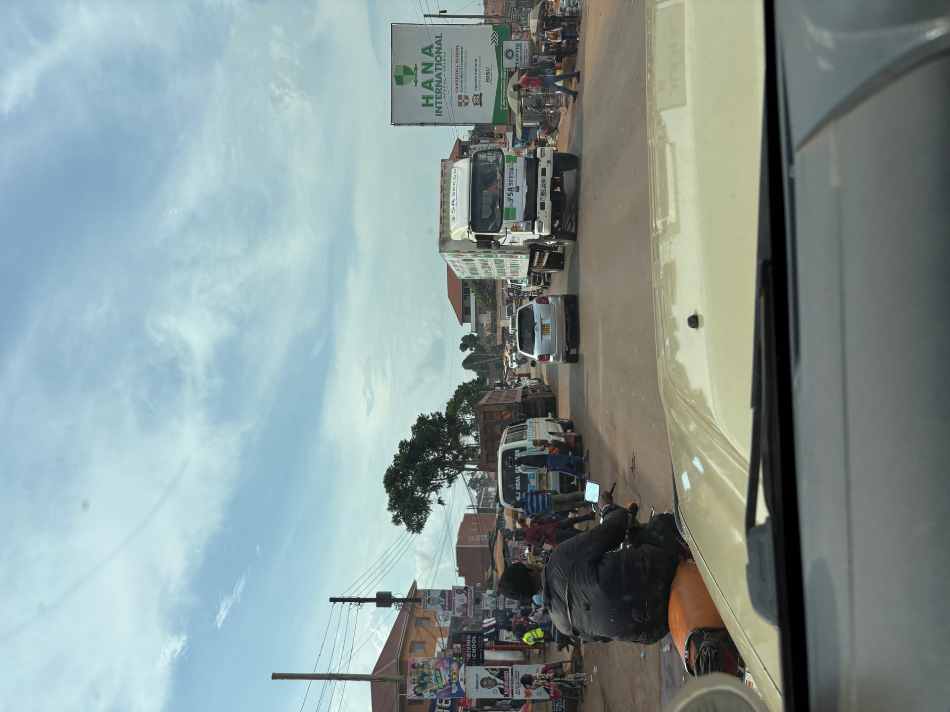
For visitors in private transfers or safari vehicles, the experience of these roads is primarily observational — the driver handles the navigation, the passenger watches the city unfold outside the window. This is how the images documented across the three visits were obtained: from within the vehicle, photographing through the window or from an open roof hatch, the GPS recording the location of each frame. The result is a ground-level visual record of Kampala's transport conditions that supplements the planning documents and statistics produced by the Kampala Capital City Authority — the lived texture of a city that official reports describe in aggregate.
The Safari Jeep as First Impression
The vehicle in which most international visitors first experience Kampala's streets deserves a note of its own. The safari jeep — typically a Toyota Land Cruiser or Land Rover Defender variant, usually fitted with a roof rack and sometimes a roof hatch for wildlife photography — is the default transfer vehicle for organised travel in Uganda. The January 2026 arrival photograph, taken at the Entebbe airport terminal at GPS 0.0442°N, 32.4443°E, shows exactly this vehicle: a roof-racked 4WD in the pale tones that seem standard for Ugandan safari operators, its driver standing by the vehicle in the airport pickup area.
The choice of vehicle is not simply aesthetics. Uganda's road network outside the capital — and significant portions within it — requires ground clearance that a standard saloon car cannot provide. The section of the Masaka Highway under construction in January 2026, for example, had sections of loose sand and gravel where a low-clearance vehicle would have struggled. The unpaved approach roads to most national parks and many lodge properties are designed for 4WD. The safari jeep is not a tourist affectation; it is the operationally appropriate vehicle for the range of terrain that a Uganda itinerary typically covers.
The journey from Entebbe to Kampala is smooth tarmac throughout and does not require a 4WD. But visitors arriving in a vehicle that will subsequently leave the capital for safari or upcountry travel are already in the right vehicle from the moment they step out of the airport terminal — which is, in practical terms, exactly how the logistics should work.
The Overloaded Minibus: Uganda's Creative Logistics
On the October 2024 journey north from Butiru toward Murchison Falls National Park — a well-surfaced tarmac road through open savannah — the vehicle encountered a transport scene that has become one of the most memorable images from that trip. A minibus traveling in the same direction was carrying a cargo load on its roof rack that stood roughly twice the height of the vehicle itself: mattresses, rolled bedding, and household goods roped into a tower of improbable geometry. The GPS coordinates 1.9624°N, 31.7122°E place the photograph precisely on the Murchison route, in good road conditions that clearly gave the driver confidence in the stability of his load.
The image is striking, and it was noted at the time as something that would be immediately impounded in a European context. But the operative question is not whether it is dangerous — it obviously is, by any standard measure — but what function it is serving. The answer is the same as for the water canister bodaboda: household goods need to move between locations, and the available vehicle is being used to its full capacity because that is the economically rational thing to do. The formal logistics system that would make this unnecessary — reliable parcel services, affordable freight companies, a functioning consumer credit market that allows staged furniture purchases rather than one-time bulk transport — does not yet operate at the scale and price point that would displace this solution.
This pattern — creative adaptation to fill the gap between what formal systems provide and what people need — is one of the defining characteristics of Uganda's informal economy, and it is visible at every level from the bodaboda rider with water canisters to the minibus with roof-stacked mattresses. It is not unique to Uganda; the same adaptive logic operates across sub-Saharan Africa and in urban economies at comparable development stages globally. What is distinctive about Uganda is the particular form it takes: the specific mix of motorcycle culture, the red laterite soil that marks so much of the road network, the particular vegetation of the eastern African plateau, and the character of the people navigating all of this with a pragmatism and good humour that visitors consistently note and find difficult to explain in European terms.
Bodaboda Culture and Lake Victoria
The connection between Kampala's bodaboda culture and Lake Victoria is not merely geographic — the city sits on the lake's northern shore, and the roads that bodabodas traverse extend from the urban core to the shoreline settlements, landing sites, and fishing communities that make the lake's Ugandan edge. The bodaboda is the vehicle by which fish moves from lake to market, by which water moves from point-of-access to household, by which people travel between the fishing villages that line the shore and the urban services they require.
The KCCA's records indicate the existence of a Kampala Fisheries Infrastructure Improvement Project focused on landing sites and markets in the Kampala area — a programme that recognises the importance of the lake's fishing economy to the city and the role of informal distribution networks in moving its product. A fish landing site in one of Kampala's shoreline communities without bodaboda access is a fish landing site that cannot efficiently supply the city's markets. The motorcycle is the link in the cold chain — such as it is in a context without consistent refrigeration — that makes urban fish consumption possible at the scale the city requires.
Water hyacinth, the invasive aquatic plant that has spread across significant portions of Lake Victoria since the 1990s, also intersects with the bodaboda economy in ways that are not immediately obvious. Landing sites blocked by hyacinth mats cannot be easily accessed by boats, which disrupts the supply chain that bodabodas extend inland. When hyacinth coverage increases — as it does seasonally and in response to nutrient loading from the city's drainage — the informal transport network that depends on functioning landing sites is directly affected. The bodaboda rider waiting at a landing site for a fish load to carry to market is part of the same ecological and economic system that includes the lake's water quality, its fish stocks, and the adequacy of the city's drainage infrastructure.
Traffic Safety and Helmet Use
The safety record of Uganda's bodaboda network is a significant public health concern that any honest account of this transport mode must address. Motorcycle accidents are a leading cause of road injury across Uganda, and the lack of helmet use — observed consistently across all three documented visit periods — is a direct contributor to the severity of injuries when accidents occur. The bodaboda rider with water canisters photographed in October 2024 was wearing no helmet and sandals rather than closed footwear. This is not unusual: it is the norm.
Uganda's traffic legislation requires helmet use for both rider and passenger on motorcycles, but enforcement on bodabodas — particularly outside urban centres and away from formal police posts — is limited. The economics of helmet ownership also matter: a helmet costs money that many riders do not have or do not prioritise given the competing demands on their income. Passenger helmets, which are legally required for passengers, are even less consistently available or used.
The KCCA has worked on bodaboda regulation as part of its transport governance mandate, including registration requirements and stage (designated waiting point) systems intended to bring some order to a mode of transport that by its nature resists formalisation. The results have been partial. The bodaboda network is too large, too distributed, and too economically essential to be meaningfully constrained by regulatory pressure that is not matched by economic alternatives. For visitors using bodabodas — for a short hop across the city, or in areas where no other transport is available — the practical recommendation is to carry a helmet if possible and to establish clearly before boarding that a helmet is available. In practice, many visitors use bodabodas without helmets, in full awareness of the risk, because no alternative exists for that particular journey. This is the same cost-benefit calculation that millions of Ugandans make every day.
Kampala as a Travel Experience: Practical Notes
For visitors arriving in Uganda via Entebbe and heading through Kampala — whether transiting to a safari destination or staying in the city — the following practical observations come directly from the documented visits across October 2024, January 2026, and May 2026.
The traffic in Kampala is best avoided during morning peak hours (roughly 7–9 am) and evening peak hours (5–7 pm). International flights into Entebbe often arrive in the early morning or late at night, which means the Entebbe–Kampala drive frequently falls outside these windows — an incidental advantage of the flight schedule. Mid-morning arrivals can expect a reasonable journey; early evening arrivals should budget generously for time.
The city's road surface on main arteries has improved significantly as a result of the Kampala City Roads Rehabilitation Project — the KCRRP works covering 88 km and 27 junctions are visible in the quality of the tarmac on sections that were notoriously poor until recently. Secondary streets are more variable, and the red laterite dust that characterises unpaved sections in dry conditions is present on construction sites throughout the city. Vehicles with open windows in these conditions collect dust rapidly; air conditioning is an asset, not a luxury.
The Masaka Highway heading southwest — documented in its January 2026 construction-phase condition at GPS 0.1061–0.1065°N, 32.1716–32.1723°E — was a study in the difference between a road's formal designation and its actual surface quality during rehabilitation works. The same route in its completed state will be substantially faster and more comfortable. Construction phases on Ugandan main roads are long; checking current conditions before a planned journey along a known rehabilitation project is sensible practice.
[QUOTE: Kampala bodaboda rider on daily routes and road conditions — collect on next visit]