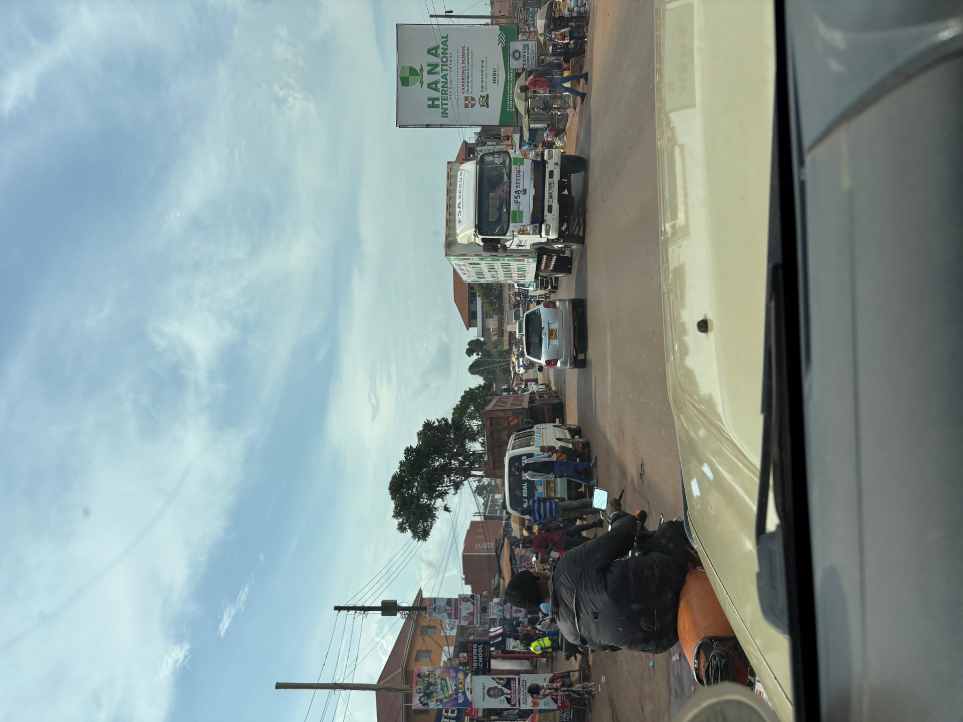
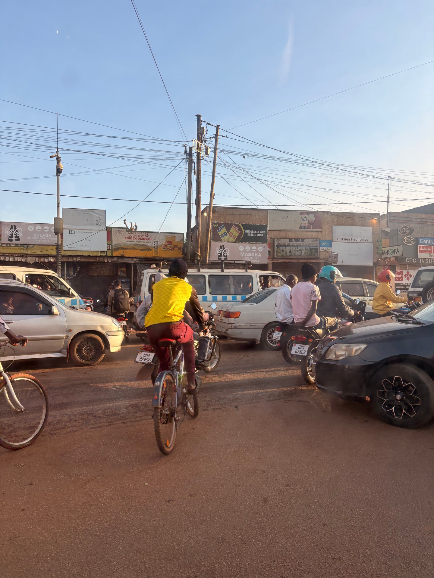
After being picked up from Entebbe International Airport — itself sitting on a peninsula that juts directly into Lake Victoria — our driver navigated us north through the full length of Kampala. Nothing quite prepares you for it. The road fills immediately: bodaboda motorcycle taxis weave between lorries, minibuses overtake on the inside, and pedestrians step confidently into gaps that a European driver would not attempt. The roadsides are alive with commerce — phone credit vendors, fruit piled high on wooden tables, welding workshops open to the street, hairdressers working under corrugated awnings. The city does not ease you in gently. During that January 2026 drive and a separate October 2024 visit, photographer Mark Suer documented the experience from inside the vehicle, the GPS on his camera recording the coordinates that place these images firmly in Kampala's urban core.
What most visitors do not realise, looking out at that traffic, is that Kampala is a lakeside city. Over 19 kilometres of its boundary runs along the northern shore of Lake Victoria, according to the KCCA Strategic Plan 2025. The lake is present — in the fish on every restaurant menu, in the fishing boats visible from certain hillsides, in the humid air — but it takes a deliberate effort to reach the water from the city centre. Understanding the relationship between Kampala and Lake Victoria means understanding an urban system in rapid, sometimes turbulent, transition: a city of over 1.65 million people managing its lake shore, its roads, its waste, and its fishing economy all at once.
Kampala's Relationship with Lake Victoria
The phrase "lakeside city" sounds serene. The reality of Kampala's relationship with Lake Victoria is more complicated and considerably more interesting. The city grew on seven hills — Kampala Hill, Nakasero, Mengo, Rubaga, Namirembe, Kibuli, and Nsambya — positioned a few kilometres from the shore rather than directly on it. This topography shaped everything: the lake was a resource and a boundary, but not a front door. Colonial-era development reinforced this pattern, pushing the central business district inland and leaving the shoreline as a working zone of fishing landing sites, light industry, and informal settlement.
Today the KCCA Strategic Plan explicitly identifies the Lake Victoria shoreline as a development priority, listing plans to extend Kampala's urban fabric along those 19 kilometres of waterfront. The challenge acknowledged in the same document is substantial: existing settlements cluster densely along the shore, and any meaningful redevelopment requires compensation costs that constrain what is financially realistic. This tension — between the strategic value of lakefront land and the human communities already living on it — defines Kampala's waterfront question more honestly than any promotional brochure would.
The Kampala Physical Development Plan (KPDP), first adopted in 2013, forms the overarching spatial framework for the city's growth. Subsequent detailed planning has been carried out for specific precincts — Kololo, Makerere, and Mulago among them — translating the KPDP's broad land-use strategies into site-level proposals. Each precinct plan is built on a sustainability model intended to address climate change at both city and neighbourhood scale, aiming to create orderly, functional neighbourhoods rather than simply expanding the existing built fabric outward. Where the shoreline is concerned, the KPDP treats the lake both as an ecological asset requiring protection and as an economic opportunity for tourism and transport infrastructure.
Wetlands and Biodiversity Along the Shore
The area between Kampala's built edge and Lake Victoria is not a clean boundary. Much of the transition zone consists of wetlands — papyrus swamps, seasonally flooded grassland, and fringing forest — that perform critical ecological functions: filtering urban runoff before it reaches the lake, absorbing floodwater that would otherwise inundate low-lying residential areas, and providing habitat for birds and fish species that depend on shallow-water breeding grounds. The KCCA Strategic Plan for 2025–2030 includes a commitment to complete a full wetland inventory for Kampala city and to develop a wetland management strategy, with targets set for creating ecotourism sites based on wetland biodiversity. At the time of the plan's publication, that inventory work was still in early stages, indicating that a comprehensive picture of what remains — and what has already been built over — was not yet complete.
This matters directly for Lake Victoria's health. Several of Kampala's major wetlands drain into the lake through Murchison Bay, which previous monitoring identified as among the most polluted sections of the entire lake. Urban runoff carrying nutrients, industrial effluent, and solid waste funnelled through these wetland corridors — when the wetlands are intact they slow and partially filter this flow; when they are drained or encroached upon, the pollution load reaches the lake faster and in higher concentrations. Protecting Kampala's remaining wetlands is therefore not merely a matter of local biodiversity: it is a question of Lake Victoria's long-term water quality.
Fishing Communities and Sustainable Practices Around Kampala
Lake Victoria does not merely border Kampala — it feeds it. Fish from the lake appear at landing sites along the city's southern and eastern shore, in the markets at Nakawa and Owino, and on tables across every income level. The Nile perch fillet served at an upscale restaurant on Kololo Hill and the dried mukene sold by the cup at a roadside stall both trace their origins to the same body of water that a visitor glimpsed from a plane window on approach to Entebbe.
Several formal landing sites operate within or directly adjacent to Kampala's administrative boundaries, functioning as the first point of contact between the lake and the urban food system. These sites are more than simple docks: they are economic hubs where fish are offloaded, sorted, weighed, sold to middlemen, processed into dried or smoked product, and loaded onto vehicles for distribution across the city and beyond. The Kampala Fisheries Infrastructure Improvement Project, which operates within the city, was designed specifically to upgrade the physical infrastructure of these landing sites and associated markets — improving handling facilities, sanitation, and cold storage capacity in order to reduce post-harvest losses, which had historically been severe.
The KCCA Agricultural Resource Centre plays a supporting role in this ecosystem, providing training, agricultural advisory services, and input distribution to communities engaged in both crop farming and aquaculture within the metropolitan area. As land pressure makes traditional fishing increasingly competitive and water quality concerns reduce catches in nearshore areas, aquaculture — the controlled cultivation of fish in ponds or cages — has grown as a supplementary livelihood for communities around Kampala. The KCCA has sought to support this transition through the Agricultural Resource Centre, though the scale of aquaculture activity within the city itself remains modest compared to lake-based fishing.
Sustainability challenges are substantial. Destructive fishing practices — undersized nets, beach seining in shallow nursery areas — remain in use despite regulations. Water hyacinth, the invasive floating plant that has periodically smothered large areas of Lake Victoria's surface, still affects some landing sites by blocking boat access and degrading the oxygen levels that fish require. And pollution from Kampala itself — including industrial effluent and the overflow from overwhelmed drainage systems — continues to degrade the nearshore habitats on which juvenile fish depend. Addressing these pressures requires coordination between the KCCA, the National Fisheries Resources Research Institute, and the communities whose livelihoods depend on a functioning lake.
[QUOTE: local fisher or landing site manager on changes in catch over the past decade — collect on next visit]
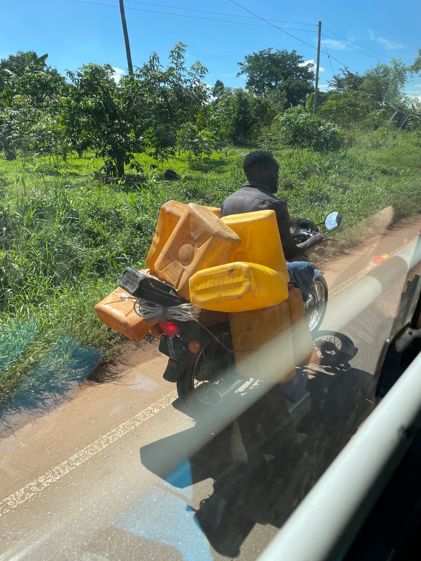
During the October 2024 visit, watching from the car on a road outside the city, Mark Suer photographed a boda boda rider carrying a full load of large plastic water containers — jerry cans stacked and tied to the frame of the motorcycle. It is the kind of image that stops a European traveller cold. No helmet, sandals on the footpegs, a load that would be refused at a European weigh station. And yet this is entirely ordinary logistics: water is not universally piped, and the boda boda is the most affordable and flexible transport available. The scene captures something essential about the economic geography surrounding Lake Victoria — a city that is modernising rapidly while simultaneously depending on systems of informal supply that have served communities for generations.
Road Infrastructure: Kampala's Largest Transformation in Decades
The traffic that greets every visitor arriving from Entebbe is not simply a feature of Kampala's character — it is a longstanding crisis that the city is now addressing with an investment scale unprecedented in its history. Several major projects are underway simultaneously, and understanding them helps visitors make sense of what they see: construction equipment on arterial roads, freshly laid tarmac alongside stretches of red-earth track, pedestrian bridges over previously uncontrolled crossings.
The Kampala City Roads Rehabilitation Project (KCRRP) was funded to a total of approximately USD 288 million through a combination of the African Development Bank, the Global Environment Facility, and the Government of Uganda (KCCA Strategic Plan 2025 — figures pending independent verification). The project covered 88 kilometres of roads and 27 junctions across the city, with supervision provided by two international engineering firms: Khatib and Alami-Saudi Consolidated Engineering Company for Package 1, and LEA Associates South Asia Pvt. Ltd. for Package 2. The involvement of international supervisory firms reflects the scale and technical complexity of the work, which in Kampala's context — hilly terrain, high traffic volumes, frequent heavy rain — presents genuine engineering challenges beyond what a straightforward flat-city resurfacing programme would require.
Running alongside the KCRRP is the Kampala City Roads and Bridges Upgrading Project (KCRBUP), financed through UK Export Finance and executed by Colas, covering a further 127 kilometres of streets and three pedestrian bridges. A related KCCA Strategic Plan target sets construction of 109 kilometres of roads under this programme by 2026 (KCCA Strategic Plan 2025 — figures from different sections and should be verified for overlap). Taken together, these figures represent hundreds of kilometres of upgraded urban road surface, a transformation that will substantially change the daily experience of moving through the city — though during construction the disruption can be significant, and travellers should allow extra time when routing through active work zones.
Perhaps less visible but equally consequential is the Kampala City Lighting and Infrastructure Improvement Project (KCLIIP), which plans to install 20,801 street lights across the city (KCCA Strategic Plan 2025). Kampala's nights have historically been poorly lit outside the central business district and main arterials, with consequences for safety, commercial activity, and the informal economy's working hours. A fully lit city street changes the character of urban life: markets can operate longer, pedestrians feel safer, and the informal transport network that runs through the night becomes more legible and less hazardous.
What Travellers Should Know When Crossing Kampala
The route from Entebbe International Airport to Kampala city centre — roughly 40 kilometres — crosses some of the most heavily upgraded road infrastructure in the country, but it also passes through construction zones that can extend journey times unpredictably. In October 2024 and again in January 2026, the drive through Kampala took longer than the distance alone would suggest: traffic does not move in orderly lanes, junctions are negotiated by assertion rather than signal, and the roadside activity — loading and unloading, informal selling, pedestrians stepping into carriageway — continuously interrupts flow.
The most practical advice for navigating this is also the simplest: build time into your schedule. The Entebbe–Kampala run, which can take 45 minutes in light traffic, takes well over two hours during peak morning and evening hours. Travel in the mid-morning or early afternoon where possible. If you are transiting Kampala rather than staying, ask your driver or guesthouse for current conditions on specific roads, as construction disruption shifts week by week. The bodaboda motorcycle taxis that move so fluidly through jammed traffic are a temptation for time-pressed travellers, but they carry genuine safety risk, particularly on Kampala's busy multi-lane roads.
Urban Planning, Waste Management and the Lake
The connection between Kampala's urban planning challenges and Lake Victoria's environmental health is direct and underappreciated. Everything that happens badly in the city — flooding, uncontrolled dumping, overflowing drainage — eventually reaches the lake through the waterways and wetlands that connect the urban watershed to the open water. The KCCA's strategic planning processes are therefore not merely administrative exercises: they are, in a meaningful sense, lake management.
The collapse of the Kiteezi landfill in the second quarter of 2024/25 illustrated this dependency in stark terms. Kiteezi had been Kampala's primary solid waste disposal site for decades, and when it failed, the city was forced to redirect waste to alternative sites in Entebbe, Katabi, and Mukono until the Buyala site could be secured (KCCA Strategic Plan 2025). The emergency distribution of waste across three sites in different directions from the city created logistical strain and, in at least one case, used sites close enough to water bodies to raise environmental concerns. The KCCA's Strategic Plan for 2025–2030 sets a timeline for decommissioning Kiteezi entirely — with 15% of decommissioning work targeted by year one, rising to 100% by year five — while building out a network of collection centres for waste separation, recovery, and recycling. The Buyala site, which sits within the Kampala Metropolitan Area, is also planned to include a material recovery facility.
Urban planning in Kampala is coordinated through the KCCA, which governs the city proper, and the Greater Kampala Metropolitan Area Urban Development Programme (GKMA-UDP), implemented jointly by KCCA and eight surrounding local governments. This metropolitan coordination matters because environmental pressures do not stop at administrative boundaries: a wetland in Wakiso district that drains into Murchison Bay affects Lake Victoria in exactly the same way as one inside Kampala's formal limits.
The KCCA's own performance metrics reveal where the city currently stands. A citizen satisfaction rating of 48% for service delivery in FY2023/24 — with a target of 85% by FY2029/30 — is an honest indicator of a gap between aspiration and experience (KCCA Strategic Plan 2025 — verify). In FY2023/24, the city processed 539 building permit applications, approving 306, granting conditional approval to 50, and deferring 258 (KCCA Ministerial Policy Statement 2024/25 — verify). The shift toward online permit submission — 485 of those 539 applications came in digitally — reflects a broader modernisation of KCCA's administrative processes, though implementation quality varies across the city's six divisions.
Tourism sits explicitly within KCCA's development strategy. A Tourist Information Centre has reportedly been operationalised (KCCA Strategic Plan 2025 — verify), and the city has set a target of welcoming 90,000 visitors at designated tourist centres by FY2029/30. Lake Victoria is named specifically as an asset in this strategy: fresh water, tropical landscape, and the proximity of the lake shore to Kampala's cultural sites form the combination the city is trying to package for international visitors. The tourism development programme allocated UGX 600 million for FY2024/25 (KCCA Ministerial Policy Statement 2024/25 — verify), a relatively modest sum that underlines how early-stage this ambition currently is.
Arriving in Uganda Through the Lake City
For most international travellers, the first real sight of Lake Victoria comes from the air — the water expanding below as the plane descends toward Entebbe on its approach over the northern lake shore. That moment, captured in an aerial photograph by Mark Suer on the Ethiopian Airlines approach from Addis Ababa, frames a view of green peninsulas, red laterite tracks winding to small settlements, and the lake stretching to the horizon in the equatorial haze. It is a perspective no street-level photograph can replicate.
The second encounter comes on the ground at Entebbe airport, where travellers are met by drivers in vehicles ranging from minibuses to the roof-racked safari jeep that picked up Mark Suer and his companions in January 2026 — comfortable, capable, and immediately evocative of the East African overland journey that follows. From Entebbe the road runs north along the lake shore briefly before climbing into Kampala's hills, and for a few minutes the lake is visible to the right, broad and calm, before the city absorbs your attention entirely.
Understanding Kampala means understanding that this is not a city that has turned its back on Lake Victoria, despite appearances. The lake is in the city's plans, in its markets, in its ecological future. The infrastructure investments now underway — roads, lighting, waste management, shoreline development — are building toward a city that intends to make that relationship more visible, more productive, and more sustainable. Whether the pace of change will keep up with the pace of growth is the question Kampala will answer over the next decade.