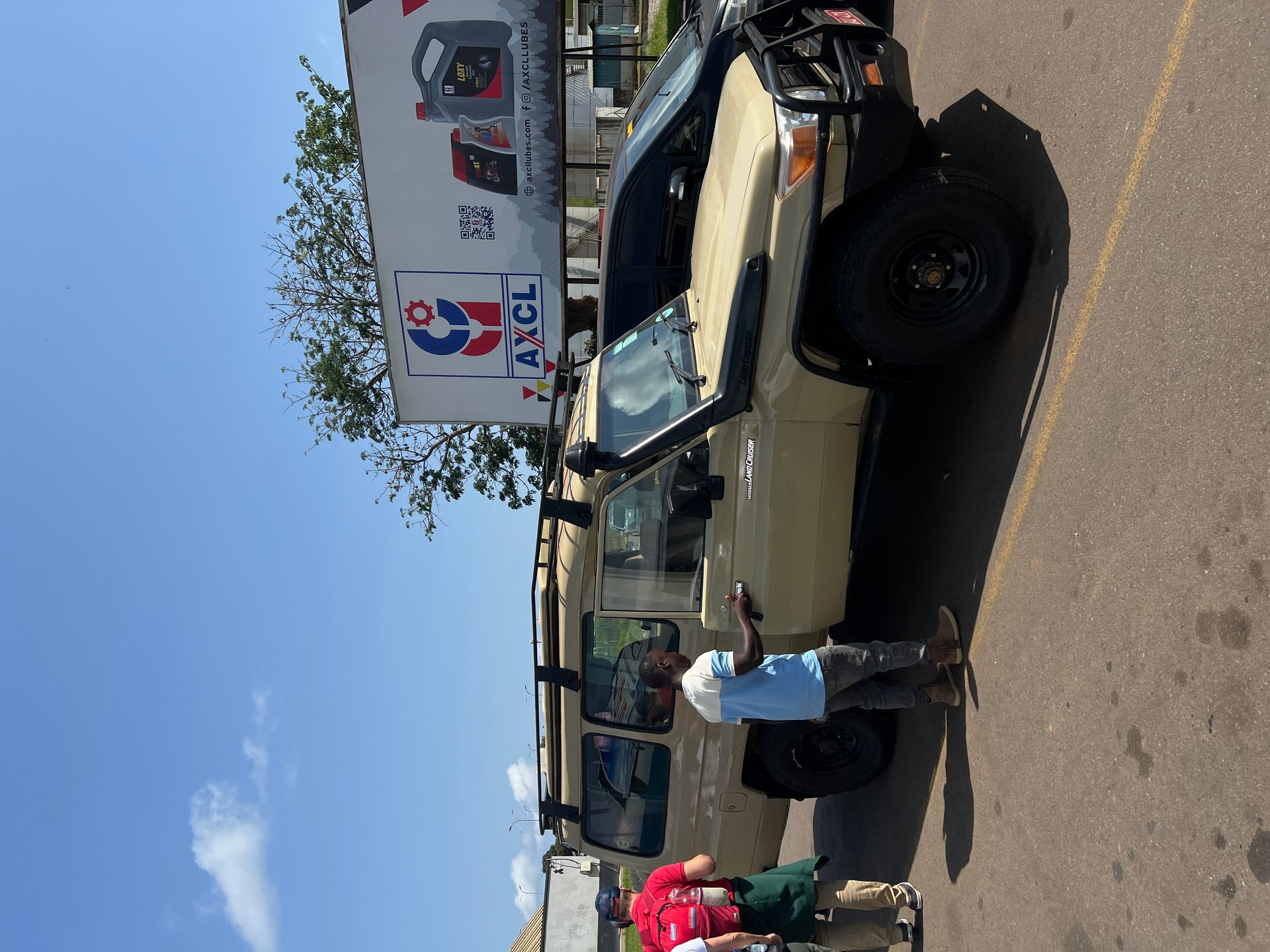
Arriving at Entebbe International Airport, January 2026 — the safari jeep that will carry you north toward Kampala and beyond. GPS: 0.0442, 32.4443 — Photo: Mark Suer
Everything you need to know about the 42 km between Uganda's international airport and its capital — and the lake that connects them
The moment of arrival in Uganda has a particular shape. You step off the plane at Entebbe International Airport and into the warm, soft air of the lake plateau, and within minutes you are in a vehicle heading north. On my January 2026 arrival, a driver was waiting at the arrivals hall with a safari jeep — the kind built for rough tracks, with a roof rack and a roll bar and enough ground clearance to handle whatever the road requires. The drive itself was comfortable. What happened forty minutes later, as the road climbed into Kampala, was something else entirely.
The transition from Entebbe's quiet peninsula — surrounded on three sides by Lake Victoria, organized around the airport and the old colonial town — to the noise and density of Kampala is total. In October 2024 and again during a three-day stay in January 2026, I made this drive multiple times, and the pattern was always the same: a calm lakeside departure, a stretch of highway that passes fishing communities and forest patches, and then a sudden immersion into a city moving at full volume. Motorcycles — the boda bodas that are Kampala's primary short-distance transport — thread between cars with casual precision. Minibuses pull in and out of stops. Roadside stalls occupy every usable strip: phone credit, grilled maize, bags of charcoal, mobile phone repair, fruit. The street itself is a commercial space as much as a traffic corridor, and the two uses coexist through a choreography that looks like chaos from the outside but functions as a coherent system.
Understanding the relationship between Entebbe, Kampala and Lake Victoria is essential for anyone travelling in Uganda. The airport sits on the lake. The capital sits above it. The 42 kilometres between them — documented in the Kampala City Statistical Abstract 2019 — contain some of Uganda's most significant landscape, ecological and logistical realities, and the lake is the thread that connects them.
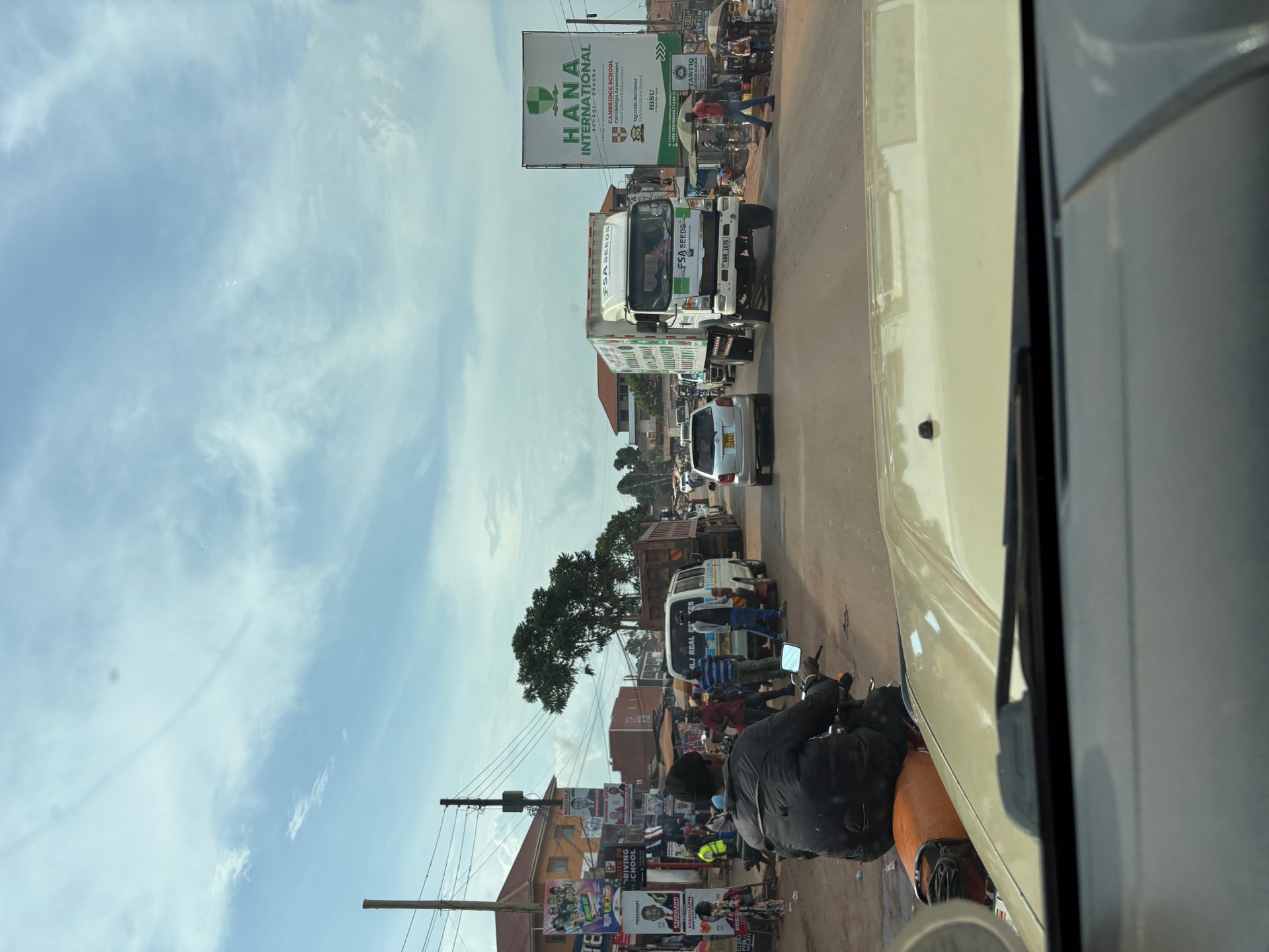
The Entebbe–Kampala corridor is Uganda's most-travelled road. Every international visitor who arrives at Entebbe International Airport must use it to reach the capital, and the volume of traffic this generates — combined with the movement of goods between the lake's fishing and port facilities and Kampala's markets — makes it one of the country's most congested routes during peak hours.
The airport itself lies at the southern end of the Entebbe peninsula, approximately 42 kilometres from Kampala's city centre (Kampala City Statistical Abstract, 2019). The road travels north along the western edge of Lake Victoria, passing through Entebbe town — still recognisable in parts from its British colonial-era layout, with wide avenues and botanical garden — before joining the Entebbe Expressway, a toll road that significantly reduces travel time when it is functioning smoothly. Without the expressway, or during periods of congestion on the older road, the journey can extend well beyond an hour.
For the first-time visitor, a pre-arranged airport transfer is the most straightforward option. On both my October 2024 and January 2026 arrivals, this meant a safari jeep — in January, a beige Land Cruiser-style vehicle with a roof rack that proved its value several days later on unpaved park tracks. Shared taxis (matatus) serve the route at a fraction of the cost but require local knowledge of departure points and may stop multiple times. A taxi-app option (including Bolt and SafeBoda) is available in Kampala itself but coverage at the airport is variable.
The Kampala Capital City Authority has been working on structural improvements to the city's transport system for several years. The Greater Kampala Metropolitan Area Multi-Modal Urban Transport Master Plan was developed in 2018 to provide a framework for managing mobility across the expanding city region. One of its most significant near-term outputs is the planned Bus Rapid Transit corridor of 14.4 kilometres, intended to provide a dedicated high-capacity public transport route through the city (KCCA Strategic Plan 2025). Complementing this, the KCCA plans to acquire and develop two bus terminals and truck parks at strategic points on the main arterial roads, with a combined budget of 18 billion Uganda Shillings (KCCA Strategic Plan 2025). The plan also targets construction of at least 15 kilometres of non-motorised transport infrastructure — dedicated cycling and pedestrian lanes — to take pressure off the road network.
The measurable ambition behind all of this is a reduction in average travel time through the city from current levels to 3.0 minutes per kilometre on urban roads by 2030 (KCCA Strategic Plan 2025). For context, anyone who has sat in Kampala traffic during a school-run afternoon will appreciate that this is a meaningful target rather than a modest one. The same plan records a parallel benchmark of 3.2 minutes per kilometre by the 2029/30 financial year — suggesting a staged improvement rather than a single step change. In May 2026, driving through Kampala again, the construction evidence of these ambitions was visible: road widening work and drainage improvements in several corridors, though progress against the backlog of deferred maintenance remained uneven across the city's different zones.
A significant piece of infrastructure linking Entebbe to Kampala's central drainage system is the Entebbe Road box culvert in the Central Division — a 50-metre structure measuring 4 by 3 metres that manages water flow under one of the approach roads (KCCA Strategic Plan 2025). Its scale reflects the engineering demands of a city where heavy rainfall events can rapidly overwhelm surface drainage on roads that carry heavy traffic year-round.
Kampala is not usually described as a lake city, even though it is one. The KCCA Strategic Plan 2025 records that Kampala has over 19 kilometres of Lake Victoria shoreline — a figure that encompasses Murchison Bay and the series of inlets, fishing landing sites and wetland edges that form the city's southern boundary. This shoreline is less visible from the city centre than the hilltop skylines that define Kampala's famous profile, but it shapes the city's ecology, its food supply and its relationship with the wider lake in ways that are impossible to overstate.
The former Lord Mayor's published address to the city, which forms part of the public record of KCCA's strategic planning, is explicit about this potential: it describes Kampala as a city with rich cultural heritage, beautiful landscapes, and fresh water bodies — with Lake Victoria specifically named — and expresses commitment to policies for preserving and developing the city's heritage and natural assets as tourism resources. That policy aspiration and the daily reality of a 19-kilometre shoreline under pressure from urban growth represent the two poles of Kampala's relationship with the lake.
The city's lakeside districts — primarily Makindye Division in the south — contain the landing sites, water treatment infrastructure and fishing communities that make the shoreline economically productive. They also absorb the runoff from one of the fastest-growing urban areas in East Africa: according to Uganda's planning data, Kampala's metropolitan area grows at approximately 5.6 percent annually, and much of that growth translates directly into built surface, reduced wetland cover and increased nutrient load reaching the lake.
The Kampala Physical Development Plan defines the regulatory boundary within which decisions about the shoreline are made. It directly borders the lake — the entity graph linking the Kampala Physical Development Plan to the Victoriasee/Lake Victoria is a structural fact rather than an abstraction — and its provisions on wetland buffers, setback distances from the shore and permitted uses in the lake-adjacent zones are the primary legal instrument protecting those 19 kilometres from further unregulated encroachment.
The most direct contact most Kampala residents have with Lake Victoria is through fish. The lake supplies tilapia, Nile perch and the small silver dagaa (locally called mukene) that appear on plates across the city, sold fresh at landing sites in the morning and distributed through market networks throughout the day. The chain from fishing boat to city consumer is short, fast and almost entirely informal — which is both its efficiency and its vulnerability.
Gaba landing site in Makindye Division is the most accessible of Kampala's lake landings for visitors. It sits roughly ten kilometres south of the city centre on a bay of Murchison Bay, and its morning activity — fish offloaded from returning boats, buyers from Kampala's markets, nets drying on frames along the bank — represents a form of urban food supply that is as old as the settlement itself. Similar activity takes place at Kasenyi, approximately eight kilometres east of Entebbe, and at the smaller sites scattered along the peninsula shoreline.
The Kampala Fisheries Infrastructure Improvement Project, which falls under the KCCA's broader programme of investment in productive urban infrastructure, has been directed at upgrading the physical facilities at landing sites like Gaba — improving handling surfaces, waste management infrastructure and the basic amenities that allow a landing site to operate at volume without degrading the surrounding environment. The rationale is both economic and ecological: a well-managed landing site loses less fish to spoilage, manages waste more effectively, and applies less direct pressure to the nearshore water quality than an unregulated one.
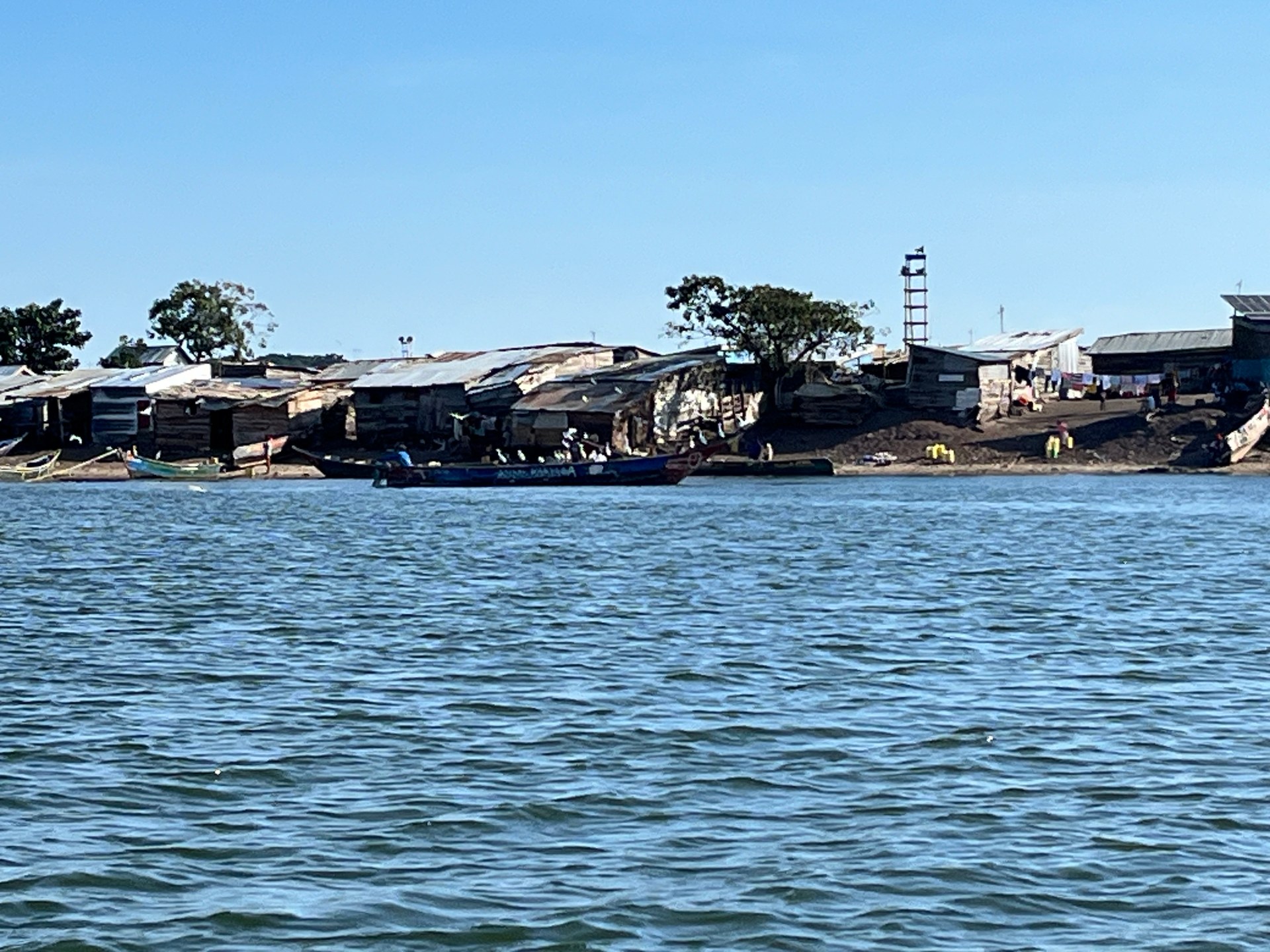
The islands of Lake Victoria, visible on clear days from the Entebbe and Kampala shorelines, host fishing communities that are entirely off-grid. During a boat crossing to Ngamba Island in October 2024, we passed one such island — small enough to cross on foot in a few minutes, densely occupied with wooden houses and corrugated iron roofs, a row of traditional boats drawn up on the bank, laundry hanging between the trees. The level of activity was striking: people moving, nets being worked on, children at the water's edge. No power lines reached the island. No visible road. The economy was entirely the lake.
The Kampala KCCA Agricultural Resource Centre, which sits within the city's governance structure alongside its fisheries programmes, provides a support pathway for urban food producers including aquaculture operators. Aquaculture — the controlled cultivation of fish in ponds or lake pens — has been expanding in Uganda's districts adjacent to Kampala, offering an alternative to wild-catch fishing that can be better managed for sustainability. The KCCA's interest in promoting this reflects a broader recognition that the wild fishery on Lake Victoria, while still substantial, is under long-term pressure from a combination of overfishing, habitat degradation and the continuing legacy of ecological disruption that the Nile perch introduction created in the mid-twentieth century.
Kampala's geographic position makes it the logical hub for travel across Uganda. Distances from the capital to the country's main destinations have been documented in the Kampala City Statistical Abstract (2019): Jinja lies 81 kilometres east, Mbarara 269 kilometres southwest, Gulu 334 kilometres north, and the park headquarters for Queen Elizabeth and other western parks are reachable in a day's drive of 4–6 hours depending on destination and road conditions. Kisoro, the gateway town for gorilla trekking in Bwindi's southernmost sector, sits 484 kilometres from Kampala.
For travellers primarily interested in Lake Victoria, the most significant day-trip destinations from Kampala or Entebbe are contained within a roughly 30-kilometre radius: Ngamba Island Chimpanzee Sanctuary (boat from Entebbe, 45 minutes); the Mabamba Swamp on the lake's northern shore west of Entebbe, the most reliable site in Uganda for shoebill stork observation; Kasenyi village for working landing site access; and the various beaches and guesthouses on the Entebbe peninsula itself.
Jinja, at 81 kilometres, is reachable as a day trip from Kampala and represents the point where the Victoria Nile departs Lake Victoria. The white-water opportunities below the Bujagali dam, the Source of the Nile monument, and the town's growing accommodation and food scene make it a credible overnight destination for travellers who want lake-to-river continuity in their itinerary. Murchison Falls National Park, at roughly 300 kilometres from Kampala, requires at least two nights to justify the drive — a point underlined by the departure time required for a game drive sunrise. In October 2024, we left our lodge before first light to be positioned for the sunrise over the savanna, and the reward — gold and orange breaking through the acacia silhouettes, the first animals visible against the lit grass — made the early alarm entirely justified.
The road north toward Murchison passes through countryside that provides its own unscripted education in Uganda's informal economy. On the route from Butiru toward the national park in October 2024, we overtook a minibus loaded with mattresses and household goods stacked on the roof to a height roughly double the vehicle's own body — the load roped in place with practised efficiency, the bus continuing at full speed. It was, as my notes record, a genuinely surreal sight from a European perspective, but it illustrated something real about how goods move in Uganda: where formal logistics infrastructure is limited, ingenuity and load capacity fill the gap.
Similarly, passing through countryside between Entebbe and Kampala in October 2024, a boda boda rider came into view carrying several large yellow water canisters — jerry cans — balanced across the seat and handlebar area. The driver wore no helmet and sandals, which for Uganda is entirely standard practice. What registered was the cargo: water, being transported by motorcycle to a community that either lacked a reliable piped supply or was resupplying during an outage. The image compressed the whole question of urban infrastructure into a single frame. Kampala has 19 kilometres of Lake Victoria shoreline. Its water treatment works at Gaba draw from the same lake. Yet water delivery by motorbike remains a daily reality for parts of the urban periphery — a gap between the lake's resource and the city's infrastructure that the KCCA's ongoing investment programme is working, systematically if slowly, to close.
Kampala's relationship with Lake Victoria is mediated in large part by how well the city manages what it puts into the environment. In the second quarter of the 2024/25 financial year, the Kiteezi landfill — which had been Kampala's primary solid waste destination for years — experienced a structural collapse that forced the city to redirect waste to alternative sites in Entebbe, Katabi and Mukono while the Buyala site was acquired as a permanent replacement (KCCA Strategic Plan 2025). The episode illustrated in concrete terms the consequences of infrastructure deferred past its operational lifespan, and the KCCA's formal plan now targets the decommissioning of Kiteezi and the construction of a new facility at Buyala as a defined objective.
The connection between solid waste management and lake health is not metaphorical. Solid waste that reaches Kampala's drainage channels eventually reaches the lake. The Nalukolongo-Kansanga-Ggaba drainage system, which carries runoff from large parts of the city's southern districts to Murchison Bay, is part of the same infrastructure network that the KCCA has been maintaining and expanding. Improving waste collection and closing informal dump sites along drainage corridors directly reduces the nutrient and pollutant load that reaches the lake.
The KCCA's Retooling Project, documented in the 2025 Strategic Plan, includes the procurement of approximately 421 vehicles — waste trucks, ambulances and other operational fleet — as a step toward meeting service standards across the city's five divisions. The Public Transport Management Committee, which oversees public mobility governance, consists of 12 members and convenes at minimum quarterly (KCCA Service Standards 2025). The Greater Kampala Metropolitan Area Urban Development Programme, implemented jointly by the KCCA and eight local governments forming the metropolitan area (KCCA Strategic Plan 2025), creates the cross-boundary framework through which investments in road, drainage and transport infrastructure can be coordinated across jurisdictions that the lake's shoreline passes through.
From the perspective of a traveller arriving at Entebbe and driving north toward Kampala, these governance structures are invisible. What is visible is the lake — flat and immense on the left of the road as you leave the airport peninsula — and then, gradually, the density of the city building around you as the road climbs. The 42 kilometres between airport and capital contain every register of Uganda's present condition: the colonial-era avenues of Entebbe, the fishing villages of the shoreline, the expressway that represents the country's infrastructure ambition, and the boda bodas and market stalls that represent its actual daily functioning. The lake is the backdrop to all of it, and for anyone who stays long enough to reach its waters — whether at Gaba's landing site at dawn or on the boat to Ngamba Island with the open water spreading south to the horizon — it resolves from backdrop into the subject itself.
Entebbe International Airport is approximately 42 kilometres from Kampala's city centre, according to the Kampala City Statistical Abstract (2019). Travel time varies significantly: the Entebbe Expressway, when traffic is light, reduces the journey to around 45 minutes; during peak hours or without the expressway, the same distance can take 90 minutes or more. Pre-arranged airport transfers with a reliable driver are the most predictable option for first-time visitors.
Options include: pre-arranged private transfer (most comfortable — safari jeeps and saloon cars both available through tour operators and hotels); shared taxi/matatu (cheapest, departs from Entebbe's taxi park, multiple stops); Bolt and SafeBoda taxi apps (useful in Kampala but variable at the airport); and the Entebbe Expressway bus service (when running). The KCCA is planning a Bus Rapid Transit system and additional bus terminals, but these are infrastructure projects in development rather than current options for travellers.
Yes. According to the KCCA Strategic Plan 2025, Kampala has over 19 kilometres of Lake Victoria shoreline along its southern edge, primarily in Makindye Division. The shoreline includes Murchison Bay, several fishing landing sites including Gaba and Kasenyi, and wetland areas. This shoreline is less well known to visitors than Entebbe's lake frontage, but it is actively used for fishing, water supply and transportation. Gaba landing site is the most accessible point for visitors wanting direct contact with the city's lake waterfront.
The most accessible lake destinations from Entebbe or Kampala are: Ngamba Island Chimpanzee Sanctuary (45-minute boat from Entebbe); the Mabamba Swamp on the northwestern lake shore (shoebill stork); the Ssese Islands (car ferry from Bukakata, 2–3 hours); and the Entebbe Botanical Garden and beach on the peninsula itself. Jinja, at 81 km east of Kampala, combines Source of the Nile access with whitewater activities and is a reasonable day trip or short overnight.
Kampala's metropolitan area grows at approximately 5.6 percent annually, adding pressure to Lake Victoria's shoreline through increased runoff, encroachment into protective wetland buffers and greater solid waste volumes reaching drainage channels. The KCCA manages this through the Kampala Physical Development Plan (which governs land use adjacent to the lake), fisheries infrastructure investment, drainage maintenance (including the Nalukolongo-Kansanga-Ggaba channel system), and the transition from Kiteezi to a new landfill at Buyala. The KCCA Strategic Plan 2025 describes the goal of 421 new operational vehicles including waste trucks to improve collection coverage across the city's divisions.