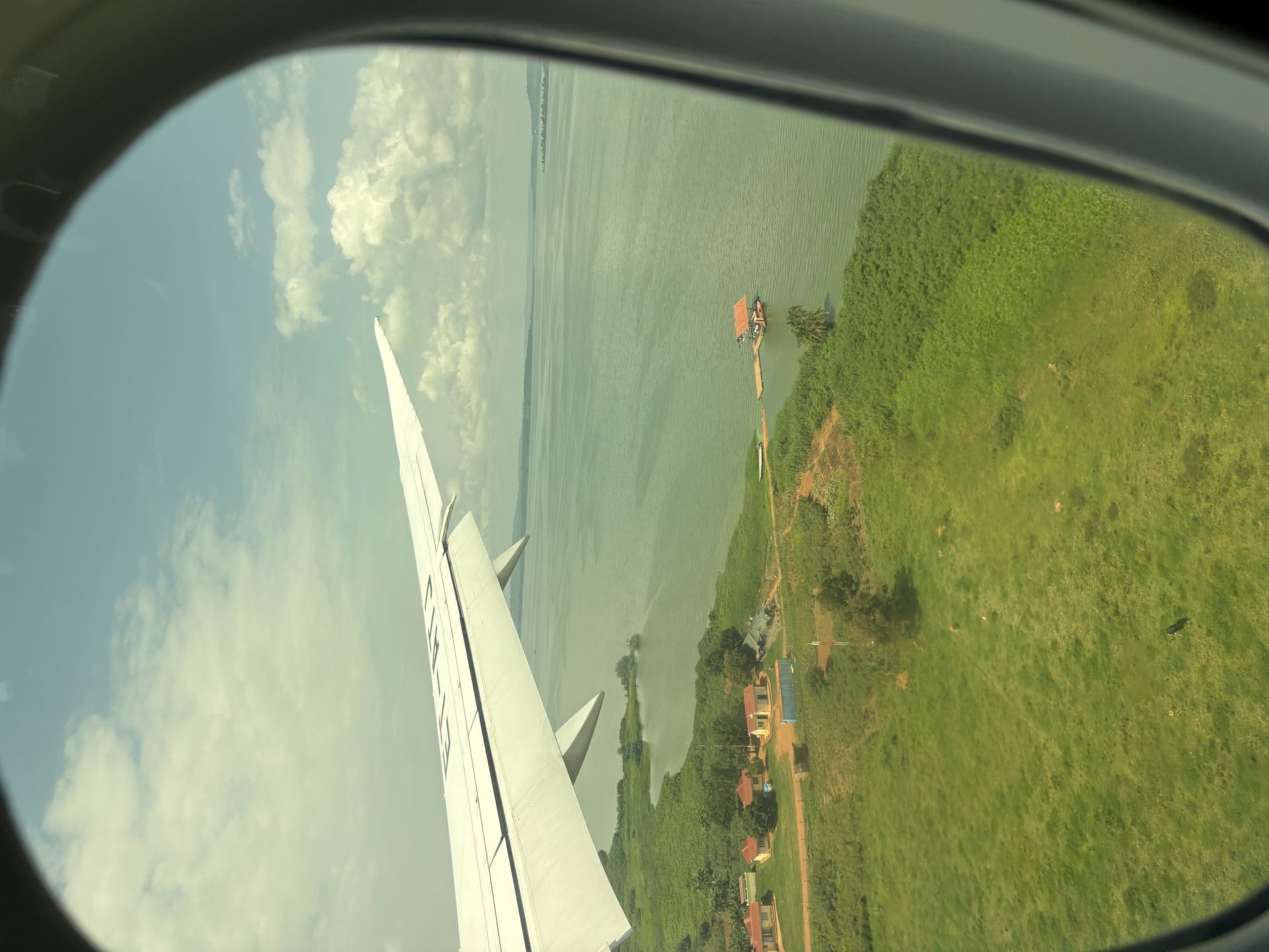
East Africa's Lake Victoria on approach to Entebbe International Airport — Photo: Mark Suer
The view from the aircraft, the chimpanzee sanctuary in the lake, water quality challenges and where to base yourself at east Africa's Lake Victoria
The first view of east Africa's Lake Victoria comes from the aircraft window, about twenty minutes before landing at Entebbe. On the approach from Addis Ababa — the Ethiopian Airlines routing that serves as the main East Africa connection for most international visitors — the lake appears below as something genuinely vast: a flat, silvery-blue expanse broken by the dark profiles of islands and the terracotta lines of laterite roads threading through green forest and agricultural land. You understand, looking at it from 5,000 feet, why early European explorers found it so difficult to map, and why the communities settled along its shores have organised their entire lives around its rhythms for thousands of years.
I arrived in Uganda on that same route in October 2024, and the aerial view over east Africa's Lake Victoria set a context that every day on the ground confirmed: this is not a lake that sits beside Uganda's story, it is woven through it. Entebbe — the town at the end of the descent, on a peninsula that pushes south into the lake's northern shore — is the closest most international visitors will ever come to the water, and for many it remains little more than a transit point on the way to Kampala. It deserves more than that. The following guide covers what to see, what the lake's ecology means at this specific stretch of shore, and how the view from the aircraft connects to the reality on the ground.
During visits in October 2024 and January 2026, I photographed the lake from boat and shore, visited Ngamba Island's chimpanzee sanctuary, and observed the fishing community life on the islands between Entebbe and the sanctuary. Six of those photographs carry GPS coordinates placing them on the water between GPS -0.1010, 32.6532 and -0.0847, 32.6508 — coordinates that verify physical presence on east Africa's Lake Victoria at the locations described in this article.
Entebbe occupies one of the more unusual positions of any town in East Africa. It sits on a peninsula that juts south into Lake Victoria, surrounded by water on three sides, with the airport at the peninsula's southern tip. The equator runs through the Entebbe area — the town is positioned right on the line that divides the northern and southern hemispheres, which means that standing on the shore of east Africa's Lake Victoria here, you are equidistant from both poles.
The equatorial location is not just a geographic curiosity. It drives the climate that makes the Lake Victoria basin what it is: the convergence of air masses from north and south produces the bimodal rainfall pattern — two rainy seasons per year — that fills the lake, sustains the agricultural land in its catchment, and generates the convective thunderstorms that make afternoon and evening boat travel risky during peak months. The equator explains the lake's temperature stability, which in turn explains the biological productivity that has supported fishing communities here for millennia.
The town itself retains traces of its colonial-era layout — wider avenues than most Ugandan towns, a botanical garden that runs along a stretch of lake shore, older administrative buildings set back from the road in compounds shaded by large trees. The Uganda Wildlife Education Centre (formerly known as Entebbe Zoo) sits on the lake shore and holds rescued animals including chimpanzees, offering a mainland preview of the primate conservation work happening on Ngamba Island offshore. The Victoria Mall near the botanical garden provides the practical infrastructure that arriving travellers need: a supermarket, telecoms, and restaurants.
What Entebbe does not have, despite its position on east Africa's Lake Victoria, is much public access to the water. The shoreline between the botanical garden beach and the fishing landing stages is largely occupied by private property, hotel grounds or government facilities. The best open access to the lake is at the botanical garden's beach — busy with families at weekends, quieter on weekday mornings — and at Kasenyi village approximately eight kilometres east of town, where the fishing community's landing site provides the most direct contact with the lake's working life.
Twenty-three kilometres south of Entebbe, set in open water, Ngamba Island hosts one of the most compelling conservation operations in East Africa. The Ngamba Island Chimpanzee Sanctuary has received rescued chimpanzees since 1998 — orphans and survivors from the illegal wildlife trade, animals confiscated from households where they were kept as pets, individuals transported from forest clearings in Uganda and neighbouring countries where their family groups were killed. The island provides permanent home to these animals rather than attempting to return them to the wild: most have been too heavily traumatised or too long in human company to survive independently in a forest.
Arriving at the island by boat in October 2024, the welcome was genuinely warm. The hand-painted wooden sign at the landing stage — orange letters on a weathered board, reading "Ngamba Island Chimpanzee Sanctuary" — had the character of a place built by conviction rather than branding. The reception area was modest and hospitable. Everything about the island felt like a genuine operation rather than a constructed experience, which is the highest compliment you can pay a conservation site.
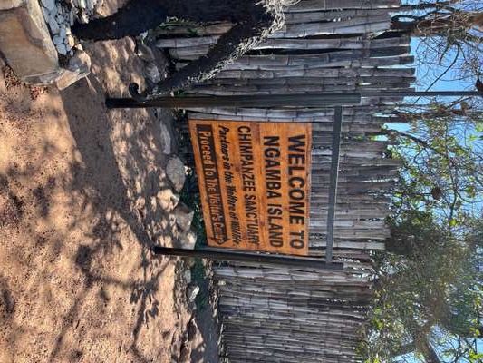
The island is approximately 100 hectares in total, with roughly 95 hectares of forested habitat available to the resident chimpanzees. The boundary between visitor area and chimpanzee territory is marked by a perimeter fence — a heavy metal structure that is functional rather than decorative. Standing at that fence for the first time, it is immediately apparent what it represents: on one side, people; on the other, animals that have been through experiences most people would prefer not to imagine. The fence looks stark, but behind it stretches real forest, and that forest means something specific to each animal on the other side of it. Freedom, in the form available to them.
Day visitors observe the chimpanzees during supervised afternoon feeding sessions from a raised viewing platform at the forest edge. The animals are not performing — they move through their own territory and happen to approach the feeding station on their own terms. Overnight stays are available for those wanting the early morning atmosphere before day visitors arrive. The boat from Entebbe takes approximately 45 minutes and passes, as ours did in October 2024, through the open lake with the mainland visible behind and the island gradually resolving ahead.
On the boat crossing to Ngamba Island in October 2024, we passed a smaller island that sits midway between the Entebbe shore and the sanctuary — an island I have not been able to identify precisely on any map under its own name. From the water, the entire island was visible at a glance: a tight cluster of wooden houses with corrugated iron roofs, a row of traditional fishing boats pulled up on a narrow beach, nets spread across frames to dry, people moving along the shore. No power lines reached it. No visible road connected any part of it to anywhere else. We watched from the passing boat for several minutes as the island's activity continued around us — children near the water, someone working on a boat hull, laundry strung between trees. The life there was entirely self-sufficient and entirely oriented toward the lake.
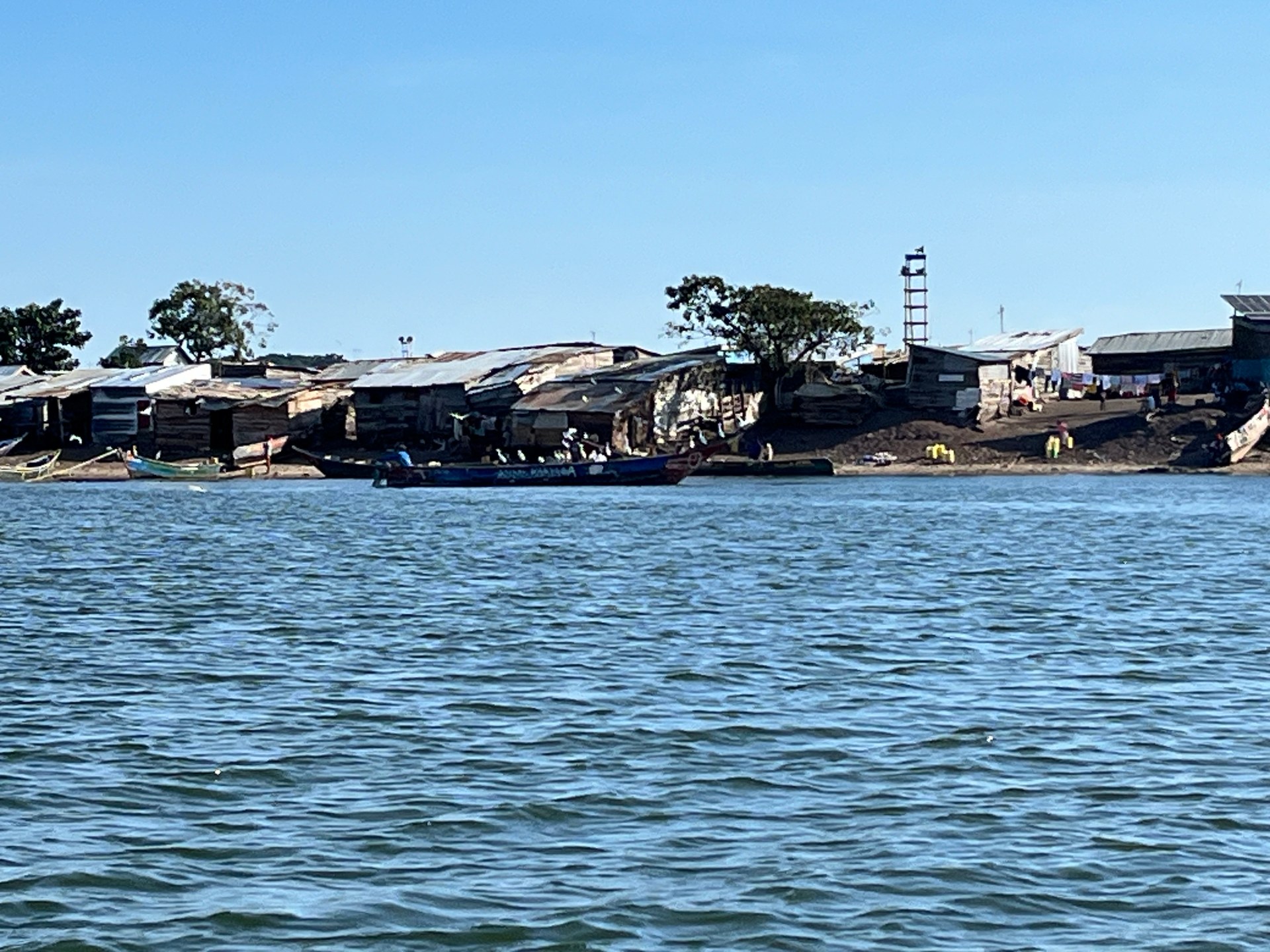
This pattern of off-grid island communities is replicated across dozens of islands in Uganda's portion of east Africa's Lake Victoria. The KCCA Strategic Plan 2025 references plans for 20 jetties around the lake for water transport and tourism — an infrastructure ambition that, if realised, would substantially change how these communities connect to the mainland and to markets. For now, the connection is by boat, on the lake's terms, and the communities' rhythm is set by weather, season and fish.
The species at the centre of this economy — Nile perch (locally called Nilbarsch), tilapia and the small silver mukene (dagaa) — represent three very different market tiers. Nile perch is the export commodity, processed at lakeside factories and frozen for European, Middle Eastern and Asian markets. Tilapia serves both local and regional markets, sold fresh at landing sites and distributed through Kampala's market network. Mukene is dried or smoked and consumed across Uganda, particularly as a protein source in inland communities far from the lake. All three depend on water that is clean enough to support their habitat — which is where east Africa's Lake Victoria faces its most pressing long-term challenge.
The National State of the Environment Report 2024 (NSOER 2024), Uganda's most comprehensive annual environmental assessment, identifies Lake Victoria's water quality as a serious ongoing concern. The most heavily polluted areas of the lake in Uganda are specifically named in that report: the inner part of Murchison Bay — which forms Kampala's southern lake frontage — together with Nakiwogo and Kitubulu Bay. These enclosed or semi-enclosed water bodies receive the concentrated output of Kampala's urban drainage, industrial effluent from the city's processing and manufacturing operations, and agricultural runoff from the intensively farmed land of the lake's catchment.
Murchison Bay's pollution is a product of its geography. The bay is large enough to function as a significant water body but enclosed enough that flushing by open-lake currents is limited. It receives the Nakivubo channel's outflow — which carries Kampala's drainage — as well as treated and partially-treated wastewater. The result is elevated nutrient levels that favour algae and water hyacinth growth, depressed dissolved oxygen in the deeper layers, and water that fails Uganda's own quality standards in multiple respects. The lake's Gaba Water Works, which draws from Murchison Bay to supply Kampala with treated drinking water, manages this reality through intensive treatment processes that add significantly to the cost of the city's water supply.
The water hyacinth (Wasser-Hyazinthen) remains present in Murchison Bay and in the bays immediately west of Entebbe — the same bays that Nakiwogo and Kitubulu Bay represent on the map. The plant is suppressed but not eradicated by the biological control programme using South American weevils, and resurges after heavy rainfall events that deliver additional nutrients from the catchment. For boat operators on this part of the lake, hyacinth management is a seasonal operational concern rather than a solved problem.
According to Uganda's National State of the Environment Report 2024, the decline in fish stocks in Lake Victoria is driven by a combination of factors working simultaneously: destructive fishing practices, deteriorating water quality, and the persistent impact of invasive species including water hyacinth. None of these factors operates independently — they reinforce each other in ways that make the problem more difficult to address than any single cause would be alone.
Destructive fishing practices include the use of undersized mesh nets that capture juvenile fish before they can reproduce, beach seining in shallow nursery areas that destroys the habitat where young fish mature, and overfishing on key species without adequate rest periods. The Lake Victoria Fisheries Organization (LVFO) sets regional management guidelines, but enforcement across a lake shared by three countries and thousands of landing sites is inherently complex.
Water quality degradation removes productive habitat. The anoxic zones that develop in polluted bays cannot support fish populations, and when fish avoid these areas, fishing pressure concentrates on the remaining productive water, accelerating overfishing there. The water hyacinth compounds this by blocking access to existing fishing grounds, creating the stagnant, oxygen-depleted conditions that further reduce habitat quality, and providing shelter for the snail hosts of bilharzia — a disease that reduces the capacity of fishing community members to work.
The mukene (small dagaa) fishery, historically the lake's most volume-significant fishery in terms of tonnage, has shown particular vulnerability to these combined pressures. Mukene are surface-dwelling schooling fish that are highly sensitive to water quality changes and are caught using light-attraction methods that, when unregulated, result in significant bycatch of juvenile Nile perch and tilapia. The Uganda Wetlands Management Program, which coordinates monitoring and restoration of wetland areas adjacent to east Africa's Lake Victoria, provides some protection to the nursery habitats that all three key species depend on during early life stages.
Entebbe's accommodation offer covers a range from budget guesthouses to boutique hotels, most within a short distance of the lake shore or the airport. The town's position as Uganda's sole international gateway means that there is a reliable stock of visitor accommodation calibrated to international travel requirements — reliable water supply, functioning WiFi, airport transfer capacity.
At the upper end, the No. 5 Boutique Hotel opened in 2018 with ten spacious rooms and five apartments — a small, carefully designed property that prioritises quality over scale. Its opening represented part of a wider trend toward boutique rather than branded-chain accommodation in Uganda's gateway towns, recognising that visitors who have already chosen a specialist destination like Uganda are looking for something more characterful than a standardised international hotel room.
The Lake Victoria Hotel, one of Entebbe's established options, sits on the shore with a large swimming pool looking out over the lake — practical and well-positioned for those who want direct water access without the boat crossing to an island. The Uganda Wildlife Education Centre's proximity makes it a convenient base for a Entebbe day that combines conservation and lakeside atmosphere without requiring any boat travel.
Budget travellers have a range of guesthouses throughout Entebbe town, many offering free airport transfers — a relevant consideration given that the airport's taxi options at night or on early-morning departures can be expensive. The strip of accommodation along the Entebbe Road, between the airport and the town centre, concentrates many of these options within an easily navigable zone.
For most itineraries that begin at east Africa's Lake Victoria before continuing to Uganda's parks, spending one full day and one night in Entebbe is worth the time. A morning at Mabamba Swamp for the shoebill, an afternoon at the botanical garden beach or the Wildlife Education Centre, and a boat trip to Ngamba Island the following morning — this sequence shows the lake as a living ecological system rather than simply a backdrop to the airport. The afternoon flight or early morning departure to Bwindi or Murchison is better from that foundation than from a hotel you checked into at midnight and left before dawn.
Yes. Entebbe sits on a peninsula that extends south into Lake Victoria's northern shore, surrounded by the lake on three sides. Entebbe International Airport — Uganda's only international airport — occupies the southern end of the peninsula. The town is positioned on or very close to the equator, making it one of very few equatorial cities with direct frontage on a major freshwater lake.
According to Uganda's National State of the Environment Report 2024, the most heavily polluted areas in Uganda's section of Lake Victoria are the inner portion of Murchison Bay (which forms Kampala's southern lake frontage), Nakiwogo Bay and Kitubulu Bay. These areas receive concentrated urban drainage, industrial effluent and agricultural runoff. Water hyacinth is particularly persistent in these bays. The open lake and the waters around Entebbe, Ngamba Island and the Ssese Islands are significantly cleaner.
According to Uganda's National State of the Environment Report 2024, fish stock decline in Lake Victoria results from three overlapping pressures: destructive fishing practices (undersized nets, beach seining in nursery areas, overfishing), deteriorating water quality that removes productive habitat, and invasive species — primarily water hyacinth — that block fishing access and degrade water conditions. These factors compound each other: pollution reduces habitat, which concentrates fishing pressure on remaining productive areas, accelerating overfishing there.
Ngamba Island Chimpanzee Sanctuary is approximately 23 kilometres south of Entebbe by water, reached by a 45-minute boat crossing. Day trips and overnight stays are available, bookable through the sanctuary directly or through Entebbe-based tour operators and hotels. Departures are from Entebbe's waterfront. The crossing passes through open lake water and, typically, alongside smaller fishing islands. Early morning departures allow time at the sanctuary before the peak of the day's heat.
Entebbe has a range of accommodation from budget guesthouses with airport transfers to mid-range lake hotels and boutique properties. The No. 5 Boutique Hotel (opened 2018, ten rooms and five apartments) represents the town's upper tier. The Lake Victoria Hotel offers direct lake frontage with a pool. Many guesthouses along the Entebbe Road include free airport pickup. For most visitors, one to two nights in Entebbe is enough time to explore the town, visit the botanical garden, and take the Ngamba Island boat trip before continuing to Uganda's national parks.