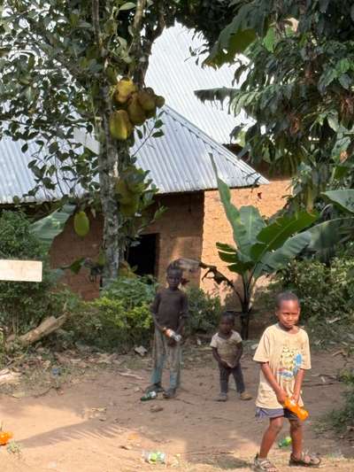
During my visit to Uganda in June 2026, I spent time in Buhoma in the southwest, photographing the community around the local orphanage. Three children — neighbours whose clothing and quiet demeanour spoke of difficult circumstances — joined us for a meal. That afternoon, GPS-tagged at -0.9617°N, 29.6109°E, I was about 600 kilometres from the Victoria Nile. But the river's reach extends far beyond its banks: through the water systems that supply these villages, through the climate dynamics that shape rainfall across the whole country, and through the floodplains of Kiryandongo where seasonal flooding each year tests the resilience of communities with far fewer resources than the one I sat with that morning.
The Victoria Nile is the first stretch of the world's longest river. It exits Lake Victoria at Jinja, Uganda's second city, carrying the accumulated drainage of more than 184,000 square kilometres of the Lake Victoria Basin. It flows northwestward for roughly 420 kilometres before reaching Lake Albert — passing through Murchison Falls National Park, where it forces itself through a seven-metre gap in the rock in one of the most dramatic waterfall sequences on the continent, and through the broad floodplains of Kiryandongo District, where water and land meet in a more troubling way each year.
For most travellers, the Victoria Nile means rafting near Jinja, boat safaris at Murchison Falls, or the scenic drive north from Kampala. But for the 164,000 refugees and the tens of thousands of Ugandan smallholders who live along the river's lower reaches in Kiryandongo District, the Victoria Nile is an annual negotiation with flood risk, drought, and the compounding pressures of a changing climate.
The Victoria Nile: From Lake Victoria to the Bunyoro Plains
Lake Victoria sits at an elevation of approximately 1,134 metres above sea level. The Victoria Nile descends from this plateau through a series of rapids and falls — Bujagali, Owen Falls (now submerged under the Nalubaale dam), and Murchison Falls — losing altitude steadily as it moves from the highlands of southern Uganda toward the lower Bunyoro Sub-region. By the time the river reaches Kiryandongo District, it has dropped significantly and flows across much flatter terrain, making it prone to spreading across the landscape during periods of heavy rainfall.
The Bunyoro Sub-region, which contains Kiryandongo District, is one of Uganda's most agriculturally productive areas. Its soils support tobacco, maize, cassava, and sorghum. The region receives rain in two seasons: a long rains season from March to May and a short rains season from October to November. But the relationship between rainfall and river flooding is not straightforward. Heavy rains in the upper catchment — including the Lake Victoria basin itself and the Rwenzori highlands to the west — can produce flooding in Kiryandongo even during dry spells locally. Conversely, extended drought can precede sudden flood events when hard, dry ground cannot absorb a rapid downpour.
The Victoria Nile's proximity to Masindi Port, at the southern tip of Kiryandongo District, creates particular vulnerability. The Masindi Port area receives the highest annual rainfall in the district, ranging from 1,582 to 2,428 millimetres per year according to CHIRPS satellite and rain gauge data analysed in the REACH Climate Hazard Assessment for Kiryandongo District (April 2026). This wide rainfall range reflects significant year-to-year variability — a pattern that has become more pronounced as regional temperatures rise.
Kiryandongo District: Where Drought and Flood Overlap
Kiryandongo District lies in Western Uganda's Bunyoro Sub-region. It borders Nwoya to the north, Oyam and Apac to the east, and Masindi to the south and west. The district is unusual in Uganda's context: it hosts one of the country's largest concentrations of refugees, with over 164,000 people from South Sudan, Sudan, and the Democratic Republic of Congo living in designated settlements. The presence of these communities means that climate shocks — floods, droughts, crop failures — affect a population with extremely limited capacity to absorb losses.
What makes Kiryandongo especially complex is that drought and flooding are not mutually exclusive threats. They occur in the same district, sometimes in the same season, affecting different zones simultaneously. According to the REACH 2026 assessment, drought or prolonged dry spells account for 49% of hazard events reported by communities in Kiryandongo, while heavy rains account for 30%. The remaining 21% includes hailstorms, strong winds, and pest infestations. In practical terms, this means that a farmer in the northeastern Mutunda Sub-county — which receives only 888 to 1,121 millimetres of rainfall annually — may be managing crop stress from a dry spell at the same time that a community near the Victoria Nile is dealing with flooded access roads.
The REACH assessment divided Kiryandongo into four rainfall zones based on long-term annual averages. The wettest zone, around Masindi Port in the far south, receives up to 2,428mm per year. Moving northward through Kigumba (1,318–1,581mm), then through the Ranch 1/Ranch 37/Bweyale zone (1,122–1,317mm), and finally to the driest northeastern area around Mutunda (888–1,121mm), rainfall decreases substantially. Refugee settlements are distributed across these zones, meaning different settlements face radically different climate profiles despite being within the same administrative district.
2022 and 2023: When the River Cut Communities Off
The human costs of flooding along the Victoria Nile corridor are not abstract. Two documented events from recent years illustrate what flood risk means for families with no alternatives.
In 2022, flooding of the Kikaito-Bakyeyo road in Kiryandongo District left pregnant women unable to reach health centres. With the road submerged and no viable alternative route, some women were forced to deliver at home under conditions that no health system would consider safe. The Kikaito-Bakyeyo road functions as a critical artery connecting communities in the district's interior to referral hospitals and clinics. When it floods, entire communities — not just pregnant women — lose access to emergency services, markets, and schools. The road's vulnerability reflects a wider pattern: in Kiryandongo, as in much of rural Uganda, infrastructure has not kept pace with climate variability.
In November 2023, flooding reached Wakisanyi Village, where temporary structures used as shelters in the Kiryandongo refugee settlement were submerged. November falls within the short rains season in Uganda, but rainfall totals in 2023 exceeded historical averages across the Bunyoro region. Temporary structures — typically constructed from materials available within settlements, including plastic sheeting, poles, and mud — have no resilience to inundation. Residents lost food stores, household items, and in some cases documentation that is difficult to replace in a refugee context.
These events did not occur in isolation. They are consistent with a regional pattern identified in climate data: the Lake Victoria basin has experienced increased rainfall variability since the late 1990s, partly linked to rising lake surface temperatures. As Lake Victoria warms, evaporation increases, adding moisture to the regional atmosphere and intensifying rainfall events when conditions align. The river that exits the lake at Jinja carries this amplified variability downstream — through Murchison Falls, and eventually into the floodplains of Kiryandongo.
Ranch 1 and Ranch 37: Refugee Settlements in the Flood Plain
Ranch 1 and Ranch 37 are two of the largest refugee settlements in Kiryandongo District. They are named for the cattle ranches that previously occupied the land — a reminder that this area was historically used for extensive livestock grazing, not intensive settlement. Both are assessed as high-risk for flooding, falling within the central zone of the district where rainfall averages between 1,122 and 1,317 millimetres annually. They are also assessed as vulnerable to drought: the REACH 2026 assessment found that both settlements experienced severely dry precipitation conditions during the March to May 2024 growing season.
The CHIRPS methodology used in the REACH assessment calculates a Standardised Precipitation Index (SPI) from 2014–2024 data, combining satellite estimates with ground-level rain gauge readings. "Severely dry" classification means that rainfall during the assessed period fell more than one and a half standard deviations below the 10-year mean. For smallholders growing maize or cassava in Ranch 1 or Ranch 37, that level of rainfall deficit translates directly into reduced yields — sometimes to complete crop failure.
The combination of flood risk and drought within the same settlements may seem contradictory, but it reflects the nature of climate instability. Extended dry periods harden the soil surface, reducing infiltration capacity. When rains finally arrive — sometimes as intense convective storms concentrated over a short period — water runs off rather than soaking in, causing flash flooding on ground that has been parched for months. This pattern is documented across East Africa and is expected to intensify as mean temperatures rise.
REACH, which stands for Research for Evidence-based Action in Crises and Humanitarian settings, has conducted similar climate hazard assessments in other Ugandan districts hosting refugee populations. Its 2026 Kiryandongo report draws on data from IMPACT Initiatives' Multi-Sector Needs Assessment (MSNA) conducted in 2024, which surveyed refugee households across the district. The combination of community-reported hazard data with satellite-derived climate indicators makes the Kiryandongo assessment one of the more methodologically comprehensive climate risk documents available for this part of Uganda.
Understanding the Hazard: What the Data Tells Visitors and Planners
For travellers heading toward Murchison Falls National Park — which lies just north of Kiryandongo District along the Victoria Nile — the climate data provides practical guidance. The main rainy season runs from March to May, with a shorter season in October and November. Road conditions in rural parts of Kiryandongo can deteriorate significantly during heavy rainfall. The route from Kampala via Masindi to Murchison Falls is generally paved and maintained, but secondary roads connecting to communities near the Victoria Nile may become impassable within hours of heavy rain. Checking conditions before driving, particularly after sustained rainfall, is advisable.
The Masindi Port area, at the southern tip of the district and closest to the lake, is the wettest part of Kiryandongo. Anyone visiting communities near the Victoria Nile should be aware that the road network here is particularly vulnerable to flooding. The Kikaito-Bakyeyo road, which follows the river corridor, has a documented history of inundation and may be impassable during the March–May season.
For development practitioners and planners, the REACH 2026 data underscores the importance of integrated climate-sensitive programming in Kiryandongo. The dual hazard of drought and flooding means that interventions designed solely for one hazard may inadvertently increase vulnerability to the other. Water harvesting infrastructure built to capture rainfall may overflow during flood events; drainage systems designed for rapid water removal may exacerbate dry-spell impacts by removing water that could otherwise recharge shallow groundwater. The complexity of the Victoria Nile's influence on this district requires approaches that work across multiple climate scenarios simultaneously.
The river that begins at Lake Victoria and carries the weight of an entire basin's rainfall northward through Uganda is not just a tourist attraction or a geographic boundary. Along the Victoria Nile, between Jinja and Lake Albert, the water that fills the lake and sustains one of the world's great river systems also floods the roads that connect mothers to hospitals, submerges the shelters that families build from what they have, and tests — every rainy season — how much resilience communities along its banks can sustain.