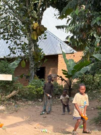
Three children stood at the edge of the space where we were eating, in Buhoma on the morning of June 21, 2026. They were from the neighborhood near the local orphanage — their clothes worn, their manner carrying the particular hesitation of children who have learned not to assume welcome. The GPS on the camera tags this moment at -0.9617°N, 29.6109°E, photographed by Mark Suer at 06:32. It is a scene from southwest Uganda, from the forested highland where mountain gorillas live and where the tourism economy creates proximity between visitors and local communities. But the vulnerability it shows — the thin margin between enough and not enough, the way that weather and harvest and access to basic services determine whether a family eats — is not confined to the southwest. Across Uganda, that margin is defined in large part by rain.
In Kiryandongo District, in western Uganda, that margin is shrinking. Kiryandongo sits along the Victoria Nile — the river that exits Lake Victoria at Jinja and carries the lake's water northward through the Ugandan interior. During fourteen visits to Uganda spanning October 2024, January 2026, April 2026, May 2026, and June 2026 — a cumulative 59 or more days on the ground — the pattern that connects Lake Victoria to the communities of Uganda's interior has become clear. The lake is not just a geographic feature on the northern edge of the country. It is the origin point of a hydrological system whose consequences reach hundreds of kilometres inland. Kiryandongo is one of the places where those consequences arrive with particular force.
This article draws on the REACH Climate Hazard Assessment for Kiryandongo District, published in April 2026 — the most recent and detailed analysis of the district's compound climate exposure — to explain what is happening in this part of Uganda's Lake Victoria basin, why it matters, and what the data reveals about the intersection of rainfall variability, agricultural livelihoods, and the lives of over 164,000 refugees who call this district home.
Kiryandongo District — Geography, the Bunyoro Sub-region, and the Victoria Nile
Kiryandongo District occupies the Bunyoro Sub-region of western Uganda, a part of the country historically known for its agricultural potential, natural resources, and, more recently, for hosting one of Uganda's largest refugee populations. The district sits within the broader Lake Victoria Basin — not directly on the lake's shore, but connected to it through the river system the lake generates. Lake Victoria, which according to the Uganda Bureau of Statistics Statistical Abstract 2014 is the world's second largest freshwater lake and the source of the River Nile, exits at Jinja in eastern Uganda and flows as the Victoria Nile northward and westward through the Ugandan interior. The Victoria Nile passes near Kiryandongo District, and its seasonal behaviour — volumes, flooding patterns, and the rainfall regimes that govern its tributaries — directly shapes the conditions in which the district's population lives and farms.
The district's terrain is not uniform. The Bunyoro Sub-region contains both the Southwestern Rangelands Agro-Ecological Zone — with its emphasis on pastoral and mixed farming — and the Karuma Masindi Oyam Tobacco Maize-Cassava Zone, which covers large parts of Mutunda Sub-county, Bweyale Town Council, and the Kiryandongo Refugee Settlement. According to the REACH Climate Hazard Assessment (April 2026), this livelihood zone is where the majority of both resident and refugee households earn their living, predominantly through subsistence agriculture dependent on seasonal rainfall. The transition from one agro-ecological zone to another within the same district creates a landscape of differentiated vulnerability: what is adequate rainfall in one area is drought in another, and what is normal seasonal flooding in one sub-county is catastrophic inundation in another.
Rainfall Across Kiryandongo — A District of Extremes
The rainfall variation across Kiryandongo District is striking enough to warrant examination in detail, because it explains why a single climate policy or a single adaptation measure cannot serve the whole district equally. The REACH Climate Hazard Assessment (April 2026) used CHIRPS — the Climate Hazard Group InfraRed Precipitation with Station data, a precipitation estimation dataset combining satellite observations with ground-level rain gauge measurements — to analyse rainfall patterns across the district over the 2014–2024 period and project future conditions.
| Area | Annual Rainfall | Primary Hazard |
|---|---|---|
| Masindi Port (southern tip) | 1,582–2,428 mm | Flooding, erosion |
| Kigumba (southwestern) | 1,318–1,581 mm | Flooding + highest warming (2.34–2.40°C) |
| Ranch 1, Ranch 37, Bweyale | 1,122–1,317 mm | Severe drought (March–May 2024) |
| Mutunda (northeastern) | 888–1,121 mm | Drought, crop stress |
Source: REACH Climate Hazard Assessment, Kiryandongo District, April 2026. CHIRPS dataset 2014–2024.
The numbers tell a story of geographic inequality within a single administrative unit. Masindi Port, at the district's southernmost tip on the Victoria Nile, receives up to 2,428 mm of rain per year — more than double the 888 mm that falls in parts of Mutunda in the northeast. This is not a year-to-year variation. It is a structural difference in the district's rainfall geography, with Masindi Port's proximity to the Nile valley and its lower elevation exposing it to entirely different moisture dynamics than the higher, drier northeastern reaches. A farmer in Masindi Port and a farmer in Mutunda face different climates, different crops, different hazards, and different needs for adaptation support — and yet both fall within the same district-level planning framework.
The Dual Hazard — Drought and Flooding in the Same District
The defining feature of Kiryandongo's climate exposure is not a single hazard but a compound one. The district faces both severe drought and destructive flooding, in different areas, sometimes in the same agricultural season. This dual-hazard profile is among the most difficult types of climate exposure to manage because the adaptive responses to drought — water storage, drought-resistant crops, irrigation — are not the same as the responses to flooding, and in some cases they are in direct tension with each other. Resources spent on flood barriers are not spent on water conservation, and vice versa.
The drought dimension was clearly documented during the March to May 2024 assessment period. According to the REACH Climate Hazard Assessment (April 2026), Ranch 1 and Ranch 37 refugee settlements in Kiryandongo District experienced severely dry precipitation conditions during this period — the highest level of drought classification used in the assessment. The standardised precipitation index (SPI) calculations drawn from CHIRPS data confirmed that rainfall during this period was far below the long-term average for the area, with consequences for crop germination, soil moisture, and pasture conditions across the settlements. High-risk areas for vegetation stress and reduced agricultural yields, as identified in the same assessment, include Ranch 1, Ranch 37, Bweyale, and Mutunda Sub-county.
The flooding dimension is equally documented, and its human cost is concrete. In 2022, flooding of the Kikaito-Bakyeyo road in Kiryandongo District left pregnant women unable to reach health centres during the event. According to the REACH assessment, some women delivered at home under conditions that the assessment characterises as risky — a direct health consequence of a road rendered impassable by seasonal flooding in a district where medical infrastructure is concentrated in a limited number of facilities. In November 2023, temporary structures in Wakisanyi Village were submerged during a flooding event — a different sub-county, a different season, the same underlying exposure to a river system that rises faster and more unpredictably than the district's infrastructure can accommodate.
Key finding (REACH, April 2026): High-risk areas for vegetation stress and reduced yields in Kiryandongo include Ranch 1, Ranch 37, Bweyale, and Mutunda Sub-counties — the same areas where over 164,000 refugees live and farm, and where subsistence agriculture is the primary livelihood source.
Temperature projections add a third dimension to the hazard picture. The REACH assessment identifies Kigumba, in the southwestern part of Kiryandongo District, as facing the highest projected warming of 2.34–2.40°C. Warming at this scale — combined with the existing rainfall variability — creates conditions for accelerating evapotranspiration, reduced effective rainfall even when total precipitation remains constant, and increasing heat stress on crops during critical growth periods. Kigumba's rainfall of 1,318–1,581 mm per year currently places it in a more favourably watered zone than Mutunda, but warming of this magnitude can substantially reduce the agricultural productivity of that rainfall by shortening viable growing windows and increasing plant water demand.
164,000 Refugees — Disproportionate Exposure to Climate Hazard
The population most exposed to Kiryandongo's compound climate hazards is also among the most structurally vulnerable: the refugees who make up a substantial portion of the district's total population. Kiryandongo District hosts over 164,000 refugees, primarily from South Sudan and Sudan, across several settlements. The Kiryandongo Refugee Settlement, located in Bweyale Sub-county, was originally established in 1990 and reopened in 2014 following renewed displacement from South Sudan. Ranch 1 and Ranch 37 are the primary settlement areas, both lying within the 1,122–1,317 mm annual rainfall zone that experienced severely dry conditions in early 2024.
The livelihoods of refugee households in Kiryandongo are predominantly built on subsistence agriculture — growing maize, cassava, and tobacco in the Karuma Masindi Oyam Tobacco Maize-Cassava Zone. This is rain-fed agriculture: there is no irrigation, and the harvest depends directly on whether the rains come on time, in sufficient quantity, and with the consistency that planted crops need across a growing season. When the rains are late, germination fails. When the rains are heavy after a dry period, erosion strips the topsoil that was left exposed by the dry spell. When the rains come in overwhelming volumes — as in the flooding events of 2022 and 2023 — the roads that connect settlements to markets and health facilities become barriers rather than connections.
There is a notable paradox in the data on Kiryandongo's refugee population: despite the severity of the climate exposure documented above, Kiryandongo's refugee settlement has been recorded as having the lowest rate of food-insecure households among Uganda's major refugee settlements. This does not diminish the climate risk — it reflects, rather, the relative adequacy of land allocation, the agricultural productivity of the district under normal conditions, and the long establishment of the refugee settlement (nearly three decades since its 1990 founding). What the REACH assessment makes clear is that this relative stability is now under pressure from climate variability that is not being addressed by the current agricultural and infrastructure support framework. A district that has managed reasonably well under historical climate conditions is entering a period in which those conditions no longer hold.
[QUOTE: refugee household or community leader in Kiryandongo on changes in rainfall patterns over the years — to be collected on next visit to western Uganda]
The REACH Assessment — Methodology and What It Means for Uganda's Refugee Response
REACH is an organisation that conducts multi-hazard climate assessments in refugee-hosting districts as part of the broader Uganda Refugee Response — the coordinated humanitarian and development framework through which Uganda manages the largest refugee population in Africa. The April 2026 Climate Hazard Assessment for Kiryandongo District is one of a series of such assessments REACH conducts in Uganda's refugee-hosting areas, using a consistent methodology that allows comparison across districts and over time.
The assessment's primary data source for precipitation is CHIRPS — the Climate Hazard Group InfraRed Precipitation with Station data — which combines satellite-based infrared measurements with ground-level rain gauge observations to produce a gridded precipitation dataset. CHIRPS data spanning 2014–2024 was used to calculate the Standardised Precipitation Index (SPI) for different areas within Kiryandongo District, identifying periods and locations of statistically significant departure from long-term rainfall norms. The 2024 assessment period, particularly March to May, showed Ranch 1 and Ranch 37 at severely dry classification — meaning precipitation during that period was in the lowest historical percentiles for the area.
The implications for Uganda's refugee response are structural as much as logistical. A refugee settlement designed around the assumption of specific rainfall conditions — sufficient to support subsistence agriculture at land allocation rates fixed in 1990 and 2014 — becomes inadequate when those conditions shift. The REACH assessment provides the evidentiary basis for revising those assumptions: adjusting livelihood programming to account for higher drought frequency, investing in road infrastructure that can withstand the flooding events documented in 2022 and 2023, and building the health access pathways that were severed when the Kikaito-Bakyeyo road flooded with pregnant women unable to reach care.
The Victoria Nile Connection — Lake Victoria's Downstream Consequences
Understanding Kiryandongo's climate situation requires placing it within the Lake Victoria Basin — the entire watershed that drains into the lake and the downstream river system the lake feeds. Lake Victoria, as the Uganda Bureau of Statistics Statistical Abstract 2014 records, is the world's second largest freshwater lake and the source of the River Nile. The Victoria Nile exits the lake at Jinja, flowing north and west before eventually merging with the Albert Nile to form the White Nile. It passes through or near Kiryandongo District in its northward course, and the hydrology of this river system determines the baseline flood exposure of communities in the district's lower-lying areas — including Masindi Port, where the highest rainfall in the district (1,582–2,428 mm annually) combines with proximity to the Nile to create the most intense flood risk.
The connection between Lake Victoria and Kiryandongo is not merely hydrological. It is administrative: the Nile's source at Jinja is where the Victoria Nile begins its journey, and the river that passes through Kiryandongo carries Lake Victoria's water. Changes to the lake's water level — which have been documented as falling over recent decades under the combined pressure of increased evaporation, catchment rainfall variability, and managed outflows — affect the discharge volume of the Victoria Nile, which in turn affects seasonal flood patterns along the river's course. The Lake Victoria Basin is not a collection of separate problems. It is a connected system, and what happens at the lake shore is connected, through physics and hydrology, to what happens in a flood-damaged road in Kiryandongo District.
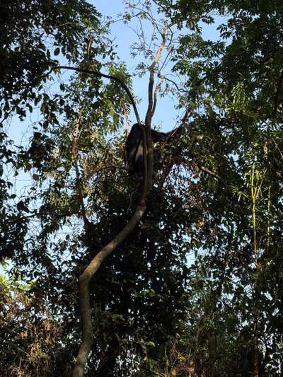
During gorilla trekking in January 2026, finding the first gorilla family after about an hour of walking in Bwindi's forest — the first animal sitting in a tree, feeding on leaves without urgency — brought into focus a dimension of Uganda's ecological situation that numbers alone do not convey. The forest is functioning. The gorillas are present. The ecosystem is intact enough to sustain a viable mountain gorilla population. But the conditions that maintain that forest — rainfall, temperature, the hydrology of highland streams — are the same conditions that, when they shift, produce the drought and flooding events documented in Kiryandongo. The forest at Bwindi and the refugee settlement at Ranch 37 are separated by hundreds of kilometres and entirely different landscapes, but they share a climate.
What the REACH assessment offers, beyond its immediate policy value for Uganda's refugee response, is a model of how to take seriously the compound nature of climate risk in a country where geography and ecology vary as dramatically as they do in Uganda. The methodology — multi-hazard, spatially differentiated, based on decade-scale precipitation data rather than single-event observations — is the appropriate tool for a district where the same year can bring severe drought in Mutunda and catastrophic flooding in Masindi Port. Applying that methodology across more of Uganda's districts, and connecting its findings to the wetland conservation and water management frameworks that govern the Lake Victoria Basin, is the work that connects the REACH report to the broader picture of what climate change means for Uganda's people and ecosystems.