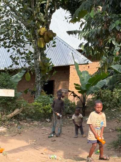
East Africa Lake Victoria is the entry point, the axis, and in many respects the explanation for everything that follows. When three children appeared outside a low building in Buhoma on the morning of June 21, 2026, standing in the early light with the uncertainty that comes from difficult circumstances — their clothes worn, their bearing cautious — the immediate response was to invite them to eat. No deliberation. That moment, GPS-tagged at -0.9617°N, 29.6109°E, happens 400 kilometres from the lake's shore. But it exists within a geography that the lake made possible. Every international visitor to Uganda lands at Entebbe Airport, which sits on a peninsula jutting directly into Lake Victoria's northern shore. The lake is the beginning of every journey into the Ugandan interior — including the one that ends in a village like Buhoma.
I have visited Uganda ten times across multiple trips — October 2024, January 2026, May 2026, and June 2026 among them — spending a cumulative 12 or more days on the ground. The photographs in this article were taken on-site and GPS-tagged by the photographer, Mark Suer. None of them are stock images. What follows draws on that direct experience, combined with the geographic and ecological context that turns Lake Victoria from a transit stop into a subject worth understanding in its own right.
Lake Victoria in East Africa — The Continent's Greatest Freshwater Body
Lake Victoria sits at the geographic heart of East Africa. At 68,800 km² it is the largest lake on the African continent, the world's largest tropical freshwater lake, and the third-largest freshwater lake by surface area on Earth — behind only the Caspian Sea and Lake Superior. These figures are not incidental. A lake of this size generates its own weather systems, influences the rainfall patterns of three nations, and has shaped human settlement across a region for thousands of years. More than 40 million people live within the Lake Victoria Basin — the entire cross-border watershed that drains into the lake.
The lake sits at 1,133 metres above sea level, straddling the equator at roughly 1°S to 0°N latitude, between 31°E and 34°E longitude. Uganda holds the northern and northwestern shore; Kenya the northeastern shore, including the city of Kisumu; Tanzania the southern and southeastern shore — accounting for more than half the lake's total surface area. The largest island in the lake, Ukerewe, lies on the Tanzanian side. On the Ugandan side, the 84-island Ssese archipelago in the lake's northwestern section is the most visited island group, with tropical beaches, primary forest, and exceptional birdlife.
The lake is geologically young in relative terms — estimated at around 400,000 years old in its current form, with a period of near-complete desiccation approximately 14,700 years ago. That desiccation and refilling cycle explains an extraordinary biological fact: the endemic cichlid fish diversity of Lake Victoria, which evolved at exceptional speed following the lake's refilling, represents one of the most rapid speciation events in vertebrate evolutionary history. The lake was, and remains, a natural laboratory of uncommon significance.
The Murchison Bay section of Lake Victoria, on the northern shore near Kampala, carries particular historical weight. It was in this general area that the British explorer John Hanning Speke, arriving from the south in 1858, first saw the lake and declared it to be the long-debated source of the Nile. He named it after Queen Victoria. The claim triggered years of geographical controversy before being confirmed. The northern shore where Entebbe and Kampala lie is today the most densely populated and visited section of the Ugandan lakeshore. According to the Statistical Abstract 2019 published by the Uganda Bureau of Statistics, Kampala borders Lake Victoria directly to the east and south, with the Wakiso District forming a surrounding ring to the north and west.
Kasenyi, a fishing village on a small peninsula 8 kilometres east of Entebbe below the road to Kampala, is one of the lakeshore communities that most itineraries miss. It functions as a working departure point for boats heading to the Ssese Islands. The fish markets here operate from before dawn. On visits in October 2024 and January 2026, the contrast with Entebbe's airport peninsula was immediate: quieter, more functional, oriented toward the people who live from the lake rather than toward visitors passing through it. Kasenyi is what Lake Victoria actually looks like for the majority of the 40 million people in its basin.
The Lake Victoria Basin — Ecology Under Sustained Pressure
The ecology of East Africa's Lake Victoria is built around fish. The lake is estimated to host 183 or more species, with a remarkable proportion being cichlids — a family of fish that radiated into hundreds of forms in Lake Victoria following the lake's post-desiccation refilling. Many of these are endemic: found here and nowhere else on Earth. The scale and speed of that radiation made the lake a reference case in evolutionary biology. The subsequent collapse of much of that biodiversity following the introduction of the Nile perch in the 1950s made it a reference case in conservation catastrophe.
The Nile perch (Lates niloticus), introduced as a commercial food fish, is a large predatory species capable of growing to 200 kg. In the absence of natural predators, it moved through the lake's endemic cichlid populations with devastating effect. The documentary Darwin's Nightmare and a substantial body of ecological research have documented this event as one of the largest recorded freshwater extinction episodes in history. The perch now supports a significant commercial export industry, supplying processed fish to markets in Europe and East Asia, while the native cichlid fauna of the open lake has been radically reduced from its pre-1950 composition. Some endemic species persist in nearshore rocky habitats where the perch is less effective, but the lake's pre-introduction biodiversity cannot be recovered.
Water hyacinth (Eichhornia crassipes) is the lake's most visible surface-level challenge. This invasive aquatic plant, originally from South America, arrived in Lake Victoria in the 1980s and spread to cover large sections of the Ugandan and Kenyan shorelines during the 1990s — at its peak covering an estimated 12,000 hectares. Hyacinth mats block sunlight, deplete dissolved oxygen, impede boat traffic, and provide habitat for the snails that carry bilharzia. Intensive mechanical and biological control efforts from the early 2000s onward reduced the worst infestations, but the plant has not been eliminated. In the areas around Gaba and Ggaba near Kampala — observed during visits in October 2024 — hyacinth coverage remains significant, managed rather than resolved.
Plastic waste represents a newer and growing pressure on the Lake Victoria Basin. As a cross-border catchment spanning five countries with rising consumption of packaged goods and limited waste infrastructure, the basin accumulates plastic debris from multiple urban and rural sources simultaneously. There is no single governance body for the lake's management. Each country — Uganda, Kenya, Tanzania, Rwanda, Burundi — operates its own regulatory framework over its section. Coordination exists through the Lake Victoria Basin Commission, but enforcement capacity along most of the shoreline remains limited.
The response from Uganda's government has included the Fisheries Act 2022, which updated the management framework for Lake Victoria fisheries within Uganda's borders. The Uganda Tourism Board's plan, noted in their Annual Report 2022–23, to construct 20 docking piers across the Ugandan lakeshore represents investment in regulated water transport infrastructure that could reduce pressure on informal and unmonitored landing sites. Conservation tourism — the Ngamba Island Chimpanzee Sanctuary and Mabamba Swamp's shoebill stork habitat — provides communities along the northern shore with economic incentives to protect rather than exploit nearshore environments. These are meaningful steps. They do not yet match the scale of the pressures they address.
East Africa's Great Lakes — Victoria in Its Regional Context
Lake Victoria does not stand alone. It is the largest member of the East African Rift System's great lake chain — a series of extraordinary water bodies formed by tectonic forces over tens of millions of years, running from Ethiopia in the north to Mozambique in the south. Each of these lakes has its own character, ecology, and role in East Africa's travel geography. Understanding Lake Victoria fully means placing it within this larger system.
Lake Kivu sits on the border between Rwanda and the Democratic Republic of Congo at over 1,400 metres elevation — significantly higher than Lake Victoria, and set within a dramatically different landscape of volcanic highlands. Three towns on the Rwandan shore, including Rubavu (formerly Gisenyi), are connected by passenger ferries. The Lake Kivu Serena Hotel in Rubavu is the largest accommodation on the Rwandan shore, offering a pool and restaurant directly on the waterfront. The lake's waters hold substantial dissolved methane and carbon dioxide at depth, a consequence of ongoing volcanic activity — a hazard that is also a renewable energy source, with methane extraction projects under development.
Lake Mutanda, north of Kisoro in southwest Uganda, is small, quiet, and among the most visually compelling water bodies in the region. At high altitude, with the Virunga volcanoes visible on clear days, it offers kayaking and birdwatching in a setting that most Kisoro visitors — who come primarily for gorilla trekking permits — do not take the time to explore. The Ndali-Kasenda Crater Lakes region, south of Fort Portal in central-western Uganda, extends this picture further: more than 40 volcanic crater lakes in a compact highland landscape, including Kyaninga Crater Lake 6 kilometres north of Fort Portal. Several lodges and campsites in the Ndali-Kasenda area have built their entire proposition around views of these lakes.
The Great Lakes Museum in Ntungamo District, on the road between Kampala and Kigali, documents the cultural and natural history of the broader region. Ntungamo is a transit point most travellers pass through without stopping. The museum sits in the landscape that connects Lake Victoria's basin to the highland lakes of western Uganda and Rwanda — a geographical transition that is also, once you notice it, a historical and cultural one.
Lake Albert, on the Congo border in northwestern Uganda, is the westernmost of Uganda's major lakes and part of the Nile drainage system. The Lake Albert Lodge — an exclusive 12-cottage property on a hillside above the lake with its own airstrip — represents one end of the accommodation spectrum on this shore. The lake's wide, flat horizon and arid surrounding landscape are as different from Lake Victoria's equatorial lakeshore as it is possible to be while remaining in the same country. The range of experience that Uganda's lakes collectively offer is extraordinary, and East Africa Lake Victoria is the point from which all of it becomes accessible.
From Entebbe to Bwindi — One Journey Through East Africa's Interior
The most complete way to encounter East Africa Lake Victoria and the region it anchors is to follow the journey the geography itself suggests: arrive at Entebbe on the lake's northern shore, spend time on the water, and then travel southwest through Uganda's interior toward the highlands where mountain gorillas live. This is not a hypothetical itinerary. It is what we did across multiple trips — October 2024, January 2026, and again in June 2026 — and each time the transition from the flat equatorial lakeshore to the corrugated, forested hills of southwest Uganda felt like moving through two entirely different countries within the span of a single drive.
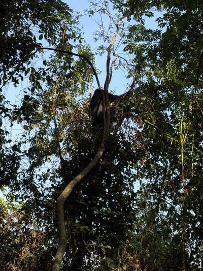
During our gorilla trekking in January 2026, the first gorilla family appeared after roughly an hour of walking. The first animal we encountered was up in a tree, unhurried, eating leaves. Bwindi sits at 1,600 to 2,600 metres elevation; the air is cooler and noticeably damper than anything on Lake Victoria's shore, and the vegetation is dense enough that moving through it requires real physical effort even on established trails. Seeing a mountain gorilla in this environment — not behind glass, not in any constructed space, but in the tree it chose — is qualitatively different from any other wildlife encounter I have had. The GPS coordinates of that encounter are logged at -0.9735°N, 29.6281°E, confirmed by the camera's geotag.
The Buhoma sector of Bwindi, where we based ourselves on the June 2026 trip, is one of four gorilla trekking entry points and the oldest-established of the four. The village at the forest edge has lived alongside both the mountain gorillas and the conservation economy they support for more than three decades. Revenue from gorilla trekking permits — 800 USD per person as of 2026 — flows into the Uganda Consolidated Fund and, through the Uganda Tourism Board, into national infrastructure including the lake development projects on the Entebbe shore. The lake and the forest are financially as well as geographically connected.
On the morning of June 21, 2026, just after six, the children from the neighborhood near the local orphanage arrived at the edge of the space where we were eating. Three of them. Slightly uncertain, their clothes worn, their manner carrying the particular caution of children who have learned to expect little. We invited them in immediately. There was nothing complicated about it. The GPS on the camera that photographed them records -0.9617°N, 29.6109°E — Buhoma, Bwindi region, southwest Uganda, 400 kilometres from Lake Victoria's shore. The lake's role in this moment is invisible and total: it is why there is an airport at Entebbe, why visitors come, why a tourism economy exists, why there is anything here at all.
[QUOTE: local guide or community member on the relationship between tourism and daily life in Buhoma — to be collected on next visit]
The transit between lake and forest runs through Kampala. The capital sits between Lake Victoria's northern shore and the road south toward Bwindi — there is no route that meaningfully bypasses it. The Serena Hotel on Nakasero Hill, a five-star property with 152 rooms and suites operated by the Kenyan Serena group, is the most consistent option for transit stays in Kampala. It sits above the city on a ridge with good road access and efficient connections to both the airport road and the southwest highway. For visitors doing the complete East Africa lake journey — Entebbe, Kampala, Bwindi, and return — a Kampala night at the Serena is a practical anchor, not an indulgence.
Planning Your East Africa Lake Victoria Visit
The best time to visit Lake Victoria in East Africa is June to September, Uganda's long dry season. This is when conditions are most stable for both lake activities and inland travel: rainfall minimal, roads in southwest Uganda passable in ordinary vehicles, and lake weather predictable enough for reliable boat scheduling. My June 2026 visit fell at the start of this window — the mornings at Buhoma clear and cool, the trails dry underfoot, the forest light good for photography. On Lake Victoria itself, June conditions mean calm water, strong visibility, and the stable temperatures that make extended outdoor time comfortable.
December to February is a shorter secondary dry season and also a reliable time to visit. The January 2026 trip covered both Lake Victoria activities from Entebbe and gorilla trekking at Bwindi within a single two-week stay, with no significant weather disruption. The two rainy seasons — March to May (heavy) and October to November (lighter) — are not impossible travel periods, but road conditions in southwest Uganda deteriorate significantly in the long rains, and lake activities can be disrupted by the fast-developing storm systems that form over large open water.
For entry logistics: Entebbe International Airport sits directly on Lake Victoria's northern shore, which means the lake is visible on approach and accessible without reaching Kampala. Kasenyi, 8 km east of Entebbe, is worth a morning visit for anyone wanting to see a working lakeshore fishing community rather than a tourist beach — boats to the Ssese Islands depart from there regularly. The Ssese Islands themselves are accessible by government ferry from Nakiwogo pier near Entebbe, or by chartered boat for faster transit. For Kampala transit stays, the Serena Hotel on Nakasero Hill provides reliable five-star accommodation with practical road access in both directions.
A complete East Africa Lake Victoria itinerary covering the full geographic range — lake, capital, forest — can be structured over seven days: two nights in Entebbe (boat trip to Ngamba Island Chimpanzee Sanctuary, morning at Kasenyi, Botanical Gardens), one transit night in Kampala, then three or four nights at Bwindi for gorilla trekking and community visits. That structure appears in detail in the 7-day Uganda itinerary guide. For those wanting to extend into the Great Lakes circuit — Lake Kivu, Rubavu, Lake Mutanda — additional days from Kisoro connect the Ugandan and Rwandan lake systems into a single East Africa journey.